Sold20191821 Cary’s Itinerary Volume Roads w/ Maps“Cary’s New Itinerary or An Accurate Delineation of the Great Roads Both Direct and Cross throughout England and Wales; with many of the Principal Roads in Scotland From ab Actual Measurement by JSee Sold Price
Sold20191821 Carys Road Maps w/ Seven Folding“Cary’s New Itinerary or An Accurate Delineation of the gReat Roads Both Direct and Cross throughout England and Wales …by John Cary; Made by Command of His Majesty’s Postmaster General…”,See Sold Price
Sold2022Britain.- Cary (John) Cary's New Itinerary..., first edition, 1798 & others, British topography (7)NO RESERVE Britain.- Cary (John) Cary's New Itinerary; or, an Accurate Delineation of the Great Roads..., first edition, engraved title and dedication, folding engraved map (water-stained, torn and reSee Sold Price
Sold2017Very Fine ANNA POTTERY / 1889 Stoneware Pig Flask w/Very Fine Cobalt-Decorated Stoneware Pig Flask with Incised Railroad Map, Inscribed "St. Louis the future Great / Latest and Only Reliable / Rail Road and River Guide / By / Anna Pottery / 1889", WallSee Sold Price
Sold2016A New Map of Louisiana, 1839Map: A New Map of Louisiana Maker: Cary & Hart, Henry Shenk Tanner with W. Brose Date: 1839 Size: Big Quarto, 10.6 inches high x 13.25 inches wide With its Canals, Roads & Distances from place to placSee Sold Price
Sold20171778 Tour of Great Britain w MAP of Scotland1778 Tour of Great Britain w MAP of Scotland + Walter Scott Poems Illustrated A collection of two works pertaining to Great Britain. An illustrated book of poetry and writings of and about Walter ScotSee Sold Price
Sold2021JOHN CARY c1798 Roads Of Britain 1st EditionJOHN CARY c1798 Great Roads Of Britain & Scotland First Edition Very Rare - CARY\'S TRAVELLER\'S COMPANION; CARY\'S NEW ITINERARY OR AN ACCURATE DELINEATION OF THE GREAT ROADS BOTH DIRECT AND CROSS THSee Sold Price
Sold2021ARCTIC: PARRY'S FIRST VOYAGE, W/ MAPS, 1821ARCTIC EXPLORATION. Rear Admiral William Edward Parry (1790-1855). PARRY'S FIRST VOYAGE. 1st edition book (1821), bound with the 1824 supplement, containing an account of the subjects of Natural HistoSee Sold Price
Sold20191802 Edition Cary's New Itinerary Great Roads“Cary’s New Itinerary or an Accurate Delineation of the Great Roads both Direct and Cross Throughout England and Wales With Many Principal Roads in Scotland”, by John Cary, London (1802). New biSee Sold Price
Sold20181774 Gemtleman's Magazine 1st Ed w/ Road MapIn it's ORIGINAL blue advertising wrapper, the "Supplement to the Gentleman's Magazine For the Year 1774", printed in London. 28 pages plus index for the year. Also a folding plate of a road map fromSee Sold Price
Sold2022Tennessee/North Carolina/VA 'Great Road' (attr) Redware Pottery JugA fantastic example from SW VA, eastern TN (possibly NW corner of NC) redware jug. 7.5"H x 5"W. The Great Road name was the main route from Roanoke, VA to Eastern TN. Part of the Great Wagon Road initSee Sold Price
Sold2022HUSKY GASOLINE SERVICE STATION MAP DISPLAY W/ HUSKY ROAD MAPS.SST. An excellent and complete example of this Circa 1950's Service Station Road Map Display from Husky showing a Tin Husky Sign at the face and complete with Maps. CONDITION: Display is in overall exSee Sold Price
Sold2020MOBIL GASOLINE SERVICE STATION TIN ROAD MAPS DISPLAY W/SST. A very nice example of this Service Station Road Maps Display from Mobil Gasoline. The paint and body are both in excellent condition, showing minimal age wear and minor surface scratches. The grSee Sold Price
Sold2020MOBIL GASOLINE SERVICE STATION TIN ROAD MAPS DISPLAY W/SST. A very nice example of this Tin Service Station Road Map Display from Mobil Gasoline. Tin is in very good condition, showing only minimal age wear and minor areas of paint loss in the corners. ThSee Sold Price
Sold20201783 Cary Map of Great Britain and Ireland -- A Map ofTitle: 1783 Cary Map of Great Britain and Ireland -- A Map of Great Britain and Ireland with all the Adjacent Isles. Year/Place: 1783, London Cartographer: J Cary Size: 10.8 X 8.8 in. Additional InforSee Sold Price
Sold2021FADEN'S MAP OF GREAT BRITAIN, 1795, FRAMEDFolding Pocket Map, "The Roads of Great Britain" by William Faden, Geographer to the King, 1795, with Supplement for the Roads of Scotland. Linen backed five by four fold, in black frame with gold linSee Sold Price
Sold2020BOBBY ORR SIGNED ADIDAS BRUINS HOCKEY JERSEY w/ GREATBOBBY ORR SIGNED ADIDAS BRUINS HOCKEY JERSEY w/ GREAT NORTH ROAD COASee Sold Price
Sold20231821 Antigua West Indies Map / W. Phillips London1821 Island of Antigua West Indies Map / W. Phillips London. Map measures 8 inches H x 10.25 W within matting, framed, 12.5 x 15 inches.See Sold Price
Sold2017Harriet Wiseman. Topless Woman.Harriet Wiseman. Topless Woman. Signed. Paint on 1821 french book cover. Great condition. 4"w x 7.5"h. Frame is 18"w x 20"h. Est. $300-500. Ship:$45See Sold Price
Sold2022Rare Late 1700's English Road Mapsc.1790 English hand-colored road maps, published by J. Cary, showing inns & pubs along the road. Lewisham to turnbridge Wells. Includes Lee, Eltham, Farningham & Maidstone etc. Maps on both front & baSee Sold Price
Sold2020VINTAGE MAP of NANTUCKET MASSACHUSETTS for YOUNGSVINTAGE MAP of NANTUCKET MASSACHUSETTS for YOUNGS BICYCLE SHOP w MACADAM ROAD VINTAGE MAP of NANTUCKET MASSACHUSETTS for YOUNGS BICYCLE SHOP w MACADAM ROAD Description Vintage Map of Nantucket, MassacSee Sold Price
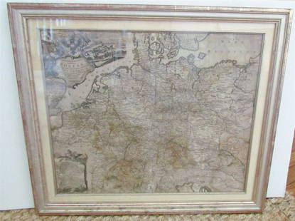
Sold20231769 ANTIQUE MAP of EUROPE framed EUROPEAN POSTAL ROADS & STATIONS1769 ANTIQUE MAP: MAPPA GEOGRAPHICA EXHIBENS POSTAS omnes tam vehiculares quam verdarias Totius Germaniae cum earum accurata distantia Diligentissime propriis sumptibus excudit. Aug. Vindelicor. : TobSee Sold Price
Sold20181814 ATLAS Maps of England & Wales Scotland Color Nav1814 ATLAS Maps of England & Wales Scotland Color Navigation Travel John Cary An incredible atlas consisting of 42 color maps of Great Britain by John Cary. The atlas covers cities in England, Wales,See Sold Price
Sold20213 New York City History Books w/Maps,Nutshell,1853-1868Lot of 3 Antique NYC History Books W Map, Illustrations. This is a great collection of 3 books documenting the history of New York City: "History of New York from the Discovery to Present Day" by, WM.See Sold Price
Featured17 hrs LeftJasper521824 Cary Map of the British Isles -- Cary's Reduction of his Six Sheet Map of the British Isles;$320
1 day LeftCedarburg Auction & Appraisals LLCSet of Four Maps Showing All of Spain and Portugal c. 1700's$450(2 bids)
Jun 08Simpson Galleries, LLC.J.H. Young (1792-1870) AN AMERICAN FEDERAL PERIOD MAP, "Mitchell's Travellers Guide Through the$500
JG AutographsBrendan Foster - Olympic Champion Runner - Autographed Hand-Painted Commemorative Postal Cover$10