Sold20221809 map of Macedonia and Thracia by SmithMacedonia et Thracia by Charles Smith. Finely detailed map shows coastal features, topographical details, rivers, Original hand coloring. Few repaired small tears at upper margin. 10.25 x 13.75 ReservSee Sold Price
Sold20231830 SDUK Map of the Balkans, Hungary and Romania -- Ancient Macedonia, Thracia, Illyria, Moesia,Title: 1830 SDUK Map of the Balkans, Hungary and Romania -- Ancient Macedonia, Thracia, Illyria, Moesia, and Dacia Cartographer: SDUK Year / Place: 1830, London Map Dimension (in.): 11.8 X 15 in. ThisSee Sold Price
Sold2021Greece and Turkey.- Münster (Sebastian) TabulaGreece and Turkey.- Münster (Sebastian) Tabula Europae IX, Ptolemaic map covering the ancient Roman provinces in the Balkans including Illyricum, Macedonia, Moesia, Thracia, Dacia, and Dalmatia,See Sold Price
Sold2022SMITH, CHARLES Smith's New General Atlas Containing District Maps of All the Principal Empires,SMITH, CHARLES Smith's New General Atlas Containing District Maps of All the Principal Empires, Kingdoms & States throughout the World. London: C. Smith, 1809. Old calf-backed boards. 15 3/4 x 12 5/8See Sold Price
Sold2022DARWIN, Charles. Geological Observations on the Volcanic Islands.... London: Smith, Elder & Co.,DARWIN, Charles (1809-1882). Geological Observations on the Volcanic Islands.... London: Smith, Elder & Co., 1876. 8vo (190 x 126 mm). 5 folding plates, 2 folding maps. (Folding plates and maps with tSee Sold Price
Sold2024An 1809 map of the postal routes of FranceAn 1809 folding map of the postal routes of France (Carte itin?raire de la France, 1809)Carte de la France donnant toutes les Routes de Postes, les lieux de Relais, les Routes des Messageries et autreSee Sold Price
Sold2023[MAP]. SMITH, W.H., compiler. Smith’s Brooklyn Directory, f...[MAP]. SMITH, W.H., compiler. Smith’s Brooklyn Directory, for the Year Ending May 1st, 1857. Being a Directory of the Inhabitants with an Avenue and Street Guide, and an Appendix. Brooklyn: CharSee Sold Price
Sold2020[Map] Smith. Ould Virginia"Ould Virginia. A description of part of the adventures of Cap. Smith in Virginia." Circa early 1800s, on wove. Measured from neatlines 14" x 10.75". Right margin and lower margin trimmed within plateSee Sold Price
Sold2019Barclay, James 1809 Map. Spain Portugal Napoleonic Wars"The Seat of War" Outline Hand Coloured Copper Engraved Map Published 1809, Leeds for "Barclay's Complete and Universal Dictionary of the English Language..." by the Rev. James Barclay. Paper Size: 10See Sold Price
Sold2021Barclay, James 1809 Map. Spain Portugal Napoleonic Wars"The Seat of War" Outline Hand Coloured Copper Engraved Map Published 1809, Leeds for "Barclay's Complete and Universal Dictionary of the English Language..." by the Rev. James Barclay. Paper Size: 10See Sold Price
Sold2022MAP OF NORTHAMPTON COUNTY, PA 1860LINEN BACKED MAP. SMITH, GALLUP & CO. PUBLISHERS, PHILADELPHIA, 1860. MEASURES 56" X 57" Terms & Conditions: Pick-up for this Auction will be Wednesday August 3rd and Thursday August 4th from 9:00am tSee Sold Price
Sold2022John Smith Map of New England, Extremely Rare 2nd StateSMITH, John (1580-1631). New England the most remarqueable parts thus named by the high and mighty Prince Charles, Prince of great Britaine. Observed and described by Captayn John Smith... CopperplateSee Sold Price
Sold2020"Apocryphal" Lewis and Clark with Map, 1809"Apocryphal" account of Lewis and Clark 1809, with fold-out map. Title pages states 5 engravings. The book contains 4 engravings that we believe are original to the book: Sioux Queen (facing title pagSee Sold Price
Sold2024Hand-Colored John Smith Map of VirginiaHand-colored John Smith Map of Virginia, dated 1608, a good early 19th c reproduction engraving, with notes on reverse, watercolorist signed lower right corner, well framed, sight 12 3/4" x 16 1/2"See Sold Price
Sold2017Antique Map: John Smith's Map of VirginiaFramed antique map. John Smith's Map of Virginia. Well-engraved early 19th century reproduction. Discovered and Described by Captain John Smith, 1606. First published in 1612, this was one of the mostSee Sold Price
Sold20181855 Smith Map of the MidWest -- Guide through Ohio,Title/Content of Map: 1855 Smith Map of the MidWest -- Guide through Ohio, Michigan, Indiana, Illinois, Missouri, Wisconsin & Iowa Showing the Township Lines of the United States Surveys Date Printed:See Sold Price
Sold2023Smith's Map of Hartford County, ConnecticutSmith's Map of Hartford County, Connecticut from actual surveys by E.M. Woodford, C.S. West Avon, published by H & C.T. Smith, 1855 engraved and printed by Wagner & Mc Guiganprinted on six plates, hanSee Sold Price
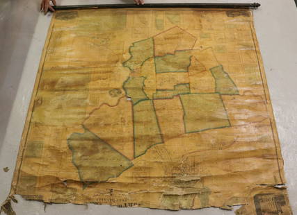
Sold2020A CADASTRAL MAP, "Deaf Smith, General Land Office, Feb.A CADASTRAL MAP, "Deaf Smith, General Land Office, Feb. 10th, 1880," LATE 19TH/EARLY 20TH CENTURY, lithograph on pale pink paper a facsimile after the original, showing the "Capitol Land Reservation,"See Sold Price
Sold20171809 Pinkerton Map of North East United States1809 Pinkerton Map of North East and Mid-Atlantic United States -- United States of America Northern Part J. Pinkerton 1809 London 20 x 27.5 in. plus matting. A detailed sharp map of the Mid-AtlanticSee Sold Price
Sold2020Gerardus Mercator Map of Macedonia ca. 1595Gerardus Mercator (1512–1594), "Macedonia Epirus et Achaia," Amsterdam, ca. 1595. Hand colored map of Macedonia and the surrounding areas. This map features beautifully executed topographical dSee Sold Price
Sold20201808 Smith Map of Cambridge UK -- A New Map of theTitle: 1808 Smith Map of Cambridge UK -- A New Map of the County of Cambridge Divided into Hundreds Date: 1808, London Cartographer: C Smith Size: 19.5 x 17.4 in. Additional Information: This is a verSee Sold Price
Sold20221839 Stiles, Sherman and Smith Map of Midwest United States and Kentucky -- Map of the WesternTitle: 1839 Stiles, Sherman and Smith Map of Midwest United States and Kentucky -- Map of the Western States Designed to Accompany Smith's Geography for Schools Cartographer: Stiles, Sherman and SmithSee Sold Price
Sold20191904 Smith Map of China -- Chinese EmpireTitle/Content of Map: 1904 Smith Map of China -- Chinese Empire Date: 1904, New York Cartographer: B Smith Size: 10.4 x 15 in. This is a very detailed map of China, with the color coded dependencies sSee Sold Price
Sold20241875 Smith Map of Africa -- Map of AfricaTitle: 1875 Smith Map of Africa -- Map of Africa Cartographer: J Smith Co. Year / Place: 1875 c. Map Dimension (in.): 8.8 X 107 in. This is an excellent map of Africa, illustrating the rapid but not cSee Sold Price
5 days LeftRbfineartsHistorical Map of the State of Kentucky by Karl Smith 1933 Daniel Boone & Companions View$30(2 bids)
1 day LeftJasper521816 VOYAGE TO ABYSSINIA by HENRY SALT w/ MAP antique 1st AMERICAN EDITION rare$400
Jun 07Freeman's | HindmanHARDY, Thomas. The Return of the Native. 1878. FIRST EDITION IN BOOK FORM, FIRST ISSUE.$500
Jun 06Freeman's | HindmanCONRAD, Joseph (1857-1924). Victory. An Island Tale. Garden City, NY: Doubleday, Page & Company,$1,000
1 day LeftJasper521868 TRAVELS in EAST INDIAN ARCHIPELAG0 by ALBERT BICKMORE illustrated ANTIQUE$170(1 bid)


![[MAP]. SMITH, W.H., compiler. Smith’s Brooklyn Directory, f...: [MAP]. SMITH, W.H., compiler. Smith’s Brooklyn Directory, for the Year Ending May 1st, 1857. Being a Directory of the Inhabitants with an Avenue and Street Guide, and an Appendix. Brooklyn: Char](https://p1.liveauctioneers.com/928/274602/144224359_1_x.jpg?height=310&quality=70&version=1673894333)
![[Map] Smith. Ould Virginia: "Ould Virginia. A description of part of the adventures of Cap. Smith in Virginia." Circa early 1800s, on wove. Measured from neatlines 14" x 10.75". Right margin and lower margin trimmed within plate](https://p1.liveauctioneers.com/3532/163584/82609292_1_x.jpg?height=310&quality=70&version=1583732116)