Sold20201788 Map of AthensAuthor: Barthelemy Title: 1788 Map of Athens Medium: Ink on Paper Dimensions: 14.5"X10.5" Description: Map of Ancient Athens dated 1788. Part of the first historical novel published in Paris by Jean JSee Sold Price
Sold2024Côte NO de l'Amérique & côte NE de l’Asie. Alaska & Kamchatka. BONNE 1788 mapTITLE/CONTENT OF MAP: [Cook 3e Voyage] Carte de la côte Nord-Ouest de l'Amérique et de la côte Nord-Est de l’Asie // Plan de l'Entrée de Nootka [Cook's 3rd Voyage - Map of thSee Sold Price
Sold2023Extremité Meridionale de l'Amérique Tierra del Fuego Magellan Str BONNE 1788 map[Cook 2e Voyage] Extremité Meridionale de l'Amérique // Partie Est de la Terre de Feu, le Détroit de Le Maire et partie ouest de la terre des Etats // Canal de Noël // Suite de la CôteSee Sold Price
Sold2024Egypte, Nubie et Abissinie. Egypt, Nubia & Abyssinia. Sudan. BONNE 1788 mapTITLE/CONTENT OF MAP: Egypte, Nubie et Abissinie [Egypt, Nubia and Abyssinia] DATE PRINTED: 1788 IMAGE SIZE: Approx 36.0 x 25.0cm, 14.25 x 9.75 inches (Large); Please note that this is a folding map.See Sold Price
Sold20171788 Map The Coasts Of Greece & the Archipelago H.RapinMap of“The Coasts Of Greece And The Archipelago From D’anville’s Atlas Executed Under The Patronage Of The Duke Of Orleans”, Engraved For John Harrison, 1788. Fine, Folds As Issued, Measures 2See Sold Price
Sold2022c. 1788 French Map of the Eastern United StatesHistoric Maps c. 1788 Map, "Les Etats Unis de L'Amerique Septentrionale, Partie Orientale" (Eastern Part of the Northern United States of America) by M. (Rigobert) Bonne c. 1788 Map titled, "Les EtatsSee Sold Price
Sold2017SDUK: Antique Map, City Plan of Athens, 1847Title/Content of Map: 'ATHENS.; inset Acropolis' Antique town city map plan Date Printed: 1847 Image Size: Approx 35.5 x 41.0cm, 14 x 16 inches (Large) Type: Antique steel engraved map with original oSee Sold Price
Sold20191788 D' Anville Folding Map of Egypt1788 map of Egypt drawn from D' Anville's atlas, engraved by John Harrison, London. Dtailed folding map, Fine,measures 20 x 16". Reserve: $20.00 Shipping: Domestic: Flat-rate of $5.00 to anywhere withSee Sold Price
Sold20241788 Gravitus Map of Asia -- Kaartje van AsiaTitle: 1788 Gravitus Map of Asia -- Kaartje van Asia Cartographer: N Gravius Year / Place: 1788, Amsterdam Map Dimension (in.): 6.8 X 9.6 in. This is an attractive small map covering all of Asia and tSee Sold Price
Sold2017Brockhaus: Antique Map of Athens, 1882Map: 1882 Brockhaus Map of Athens -- Athen Cartographer: F Brockhaus Year / Place: 1882 Leipzig Map Dimensions: 11 x 8.4 in. Condition: Very Good. Slight toning. Very good colors. Issued Centerfold. ASee Sold Price
Sold20201788 Large Map of Palestine1788 Large folding map of Palestine by D'Anville, and published here for Harrison and Co,. Fine condition, measures 20 x 16". Reserve: $30.00 Shipping: Domestic: Flat-rate of $5.00 to anywhere withinSee Sold Price
Sold2024Turquie d’Europe. Turkey in Europe. Greece & the Balkans. BONNE 1788 old mapTITLE/CONTENT OF MAP: Turquie d’Europe [Turkey in Europe] DATE PRINTED: 1788 IMAGE SIZE: Approx 24.5 x 36.0cm, 9.5 x 14.25 inches (Large); Please note that this is a folding map. TYPE: Antique 1See Sold Price
Sold20181788 Folding Map Westerly Coast of AfricaLarge folding map being "Particular Map of the Westerly Coast of Africa from Cape Blanco to Cape de Verga and of the course of the Rivers Senega and Gambia", fom D’Anvilles Atlas. Engraved for HarriSee Sold Price
Sold2022National Encyclopedia C1875 Map of Athens, GreeceWoodblock Published C1868-81 by William Mackenzie, London for "The National Encyclopedia: A dictionary of Universal Knowledge" Folds as issued. Paper Size: 12 x 9.5 inch (31 x 24cm) Good ConditionSee Sold Price
Sold2022National Encyclopedia C1875 Map of Athens, GreeceWoodblock Published C1868-81 by William Mackenzie, London for "The National Encyclopedia: A dictionary of Universal Knowledge" Folds as issued. Paper Size: 13 x 9.5 inch (33 x 24cm) Good ConditionSee Sold Price
Sold20211747 1ed Ancient GREECE Scythians Athens MAPS Sparta1747 1ed Ancient GREECE Scythians Athens MAPS Sparta Argos Universal History The “Universal History” is a mid-18th-century history of the world. Written by numerous authors and contributors, thisSee Sold Price
Sold2016Map of the States of Virginia, North Carolina...Jedidiah Morse (1761-1826), Engraved by Amos Doolittle. New Haven: Doolittle, 1788. Engraved Map. 13 1/2 x 15 1/4 inches paper size.See Sold Price
Sold2019Virginia which was the Seat of Action Rev War MapAmerican Revolution 1788 Engraved Map: "The Part of Virginia which was the Seat of Action" by T. Conder, Sculptor, London 1788 Revolutionary War Era Map titled, "The Part of Virginia which was the SeaSee Sold Price
Sold2022PURCELL, JOSEPH A Map of the States of Virginia North Carolina South Carolina and GeorgiaPURCELL, JOSEPH A Map of the States of Virginia North Carolina South Carolina and Georgia Comprehending the Spanish Provinces of East and West Florida... New Haven: Amos Doolittle, 1788. Engraved mapSee Sold Price
Sold2017Group of Maine related Paper some 2 FooterAn eclectic group of items from Maine: 1904 State Commissioner's report - missing map, Skowhegan & Athens Railroad stock certificate, Somerset Railway stock certificate, Sandy River & Rangeley Lakes 4See Sold Price
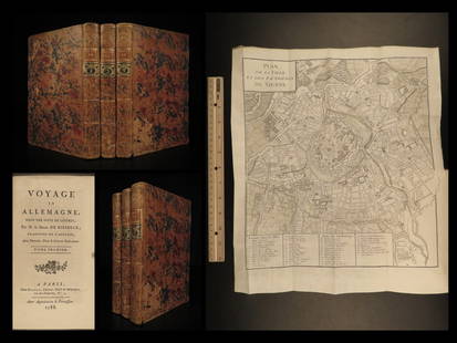
Sold20221788 Voyages Germany MAP Johann Riesbeck Letters Munich Vienna Austria 3v SET1788 Voyages Germany MAP Johann Riesbeck Letters Munich Vienna Austria 3v SET Johann Kaspar Riesbeck was a 18th-century German travel writer best-known for his book Letters from a French traveler in GSee Sold Price
Sold2017Mawman: Antique Map Plan of Athens, Greece, 1791Original copper engraving from the 1791 "Maps, Plans, Views, and Coins Illustrative of the Travels of Anacharsis the Younger in Greece". by J. Mawman, 1805. Plan of the Academy & Environs for the travSee Sold Price
Sold2017Mawman: Antique Map Plan of Athens, Greece, 1791Original copper engraving from the 1791 "Maps, Plans, Views, and Coins Illustrative of the Travels of Anacharsis the Younger in Greece". by J. Mawman, 1805. Plan of the Athens for the travels of AnachSee Sold Price
Sold2017Mawman: Antique Map Plan of Athens, Greece, 1791Original copper engraving from the 1791 "Maps, Plans, Views, and Coins Illustrative of the Travels of Anacharsis the Younger in Greece". by J. Mawman, 1805. Plan of the Athens for the travels of AnachSee Sold Price
5 days LeftJasper52Extremité Meridionale de l'Amérique Tierra del Fuego Magellan Str BONNE 1788 map$35
5 days LeftJasper52Détroit de Magellan. Strait of Magellan. Chile. BONNE 1788 old antique map$30
Jun 15Riverfront Auctions'1785 Bocage Map of the City of Athens in Ancient Greece' Par M. Barbié du Bocage$5(1 bid)
5 days LeftForum AuctionsItaly.- Rizzi-Zannoni (Giovanni Antonio) [Atlante Geografico del Regno di Napoli], c.1788-1812£500
13 hrs LeftTrillium Antique Prints & Rare BooksBloch, Folio - Blowfish or Toadfish - Tetrodon Testudineus. 139$50
13 hrs LeftTrillium Antique Prints & Rare BooksBloch, Folio - Catfish, Sheat-Fish - Silurius Glanis. 34$50(1 bid)


![Côte NO de l'Amérique & côte NE de l’Asie. Alaska & Kamchatka. BONNE 1788 map: TITLE/CONTENT OF MAP: [Cook 3e Voyage] Carte de la côte Nord-Ouest de l'Amérique et de la côte Nord-Est de l’Asie // Plan de l'Entrée de Nootka [Cook's 3rd Voyage - Map of th](https://p1.liveauctioneers.com/5584/315733/169293401_1_x.jpg?height=310&quality=70&version=1705443824)
![Extremité Meridionale de l'Amérique Tierra del Fuego Magellan Str BONNE 1788 map: [Cook 2e Voyage] Extremité Meridionale de l'Amérique // Partie Est de la Terre de Feu, le Détroit de Le Maire et partie ouest de la terre des Etats // Canal de Noël // Suite de la Côte](https://p1.liveauctioneers.com/5584/294908/156576945_1_x.jpg?height=310&quality=70&version=1688565030)
![Egypte, Nubie et Abissinie. Egypt, Nubia & Abyssinia. Sudan. BONNE 1788 map: TITLE/CONTENT OF MAP: Egypte, Nubie et Abissinie [Egypt, Nubia and Abyssinia] DATE PRINTED: 1788 IMAGE SIZE: Approx 36.0 x 25.0cm, 14.25 x 9.75 inches (Large); Please note that this is a folding map.](https://p1.liveauctioneers.com/5584/319994/171846470_1_x.jpg?height=310&quality=70&version=1708466739)


![Turquie d’Europe. Turkey in Europe. Greece & the Balkans. BONNE 1788 old map: TITLE/CONTENT OF MAP: Turquie d’Europe [Turkey in Europe] DATE PRINTED: 1788 IMAGE SIZE: Approx 24.5 x 36.0cm, 9.5 x 14.25 inches (Large); Please note that this is a folding map. TYPE: Antique 1](https://p1.liveauctioneers.com/5584/322790/173578055_1_x.jpg?height=310&quality=70&version=1710881198)


![Italy.- Rizzi-Zannoni (Giovanni Antonio) [Atlante Geografico del Regno di Napoli], c.1788-1812 (1 of 2)](https://p1.liveauctioneers.com/5458/329231/177514979_1_x.jpg?height=282&quality=70&version=1715269091)


![[Wynne, John Huddlestone (1742-1788)] (1 of 1)](https://p1.liveauctioneers.com/94/330664/178342106_1_x.jpg?height=282&quality=70&version=1716466933)


