Sold20191786 Hand Colored Map of NetherlandsMap Elwe and Langeveld - Kaartje van de X provincien der Nederlanden inhoudende Braband, Vlaanderen enz. – 1786. Fine, measures 10 x 8”. Reserve: $20.00 Shipping: Domestic: Flat-rate of $5.00 to aSee Sold Price
Sold2018Robert Vaugondy, Britan Nicae, map(French, 1723-1786), hand-colored map of Britain, dated 1750, 22 x 20 in., in giltwood frameSee Sold Price
Sold2018Antique French Copper Engraved Colored Map, Amsterdam18th century antique French copper engraved and hand colored maps of Amsterdam, Netherlands titled "Lemouicum, Auctore Jo. Faiano M.L. - Lymosin [on sheet with] Topographia Limaniae, Auctore GabrieleSee Sold Price
Sold2021Antique Engraved Map of GovdaAn antique hand colored map of Govda (Gouda, Netherlands) by J. Blaeu (1596-1673). Framed under glass. Mat opening: 15 in x 19-1/2 in.See Sold Price
Sold202417C. Willem & Jan Blaeu Map of VenezuelaWillem & Jan Blaeu Netherlands 17th Century Hand colored map of Venezuela and the lower Antilles created by Willem Blaeu and Jan Blaeu with glass back to feature atlas pages. Lithograph on paper,ImageSee Sold Price
Sold2016A Map of the United States & MexicoHenry Tanner (1786-1858). New York: Tanner, 1850. Hand-colored Pocket Map. 23 x 29 inches visible, 38 x 39 1/2 inches framed.See Sold Price
Sold20201699 De zeventien Nederlantsche Provintien; niewelyksThis attractive antique hand-colored map features the seventeen provinces of the Netherlands as they appeared at the end of the seventeenth century. Sanson's compass rose orients the map west. HistoriSee Sold Price
Sold2017FRAMED MAP OF THE NETHERLANDS, AFTER GERALD VALKFramed hand colored map, after Gerald Valk (Dutch, 1652-1726), "Provinces-Unies des Pays-Bas, avec leurs Acquisitions dans la Fladre, le Brabant, et Limbourg et le Lyege", 18.25"h, 26"w, 24"h, 32"w, 7See Sold Price
Sold2017Hand Colored Map "Carte Du Nouveau Continent"Hand colored map "Carte Du Nouveau Continent" engraved by Ambrose Tardier (French, 1788-1841), designed by Didier Robert De Vaugondy (French, 1723-1786). Framed, not examined out of frame. Stains, folSee Sold Price
Sold2020Joan Blaeu Map of Amersfoort ca. 1650Joan Blaeu (1596-1673), "Amisfurtum," Amsterdam, ca. 1650. Hand colored map of the town of Amersfoort in the Netherlands. Dimensions: Sight; height: 16 1/4 in x width: 20 1/4 in. Framed; height: 17 3/See Sold Price
Sold2019Netherlands and BelgiumTitle/Content of Map: Netherlands and Belgium Date: 1861 Cartographer: Johnson Material/Medium: steel engraved Size: 18x14” Provenance: New York Additional Info: Hand colored Reserve: $20.00 ShippinSee Sold Price
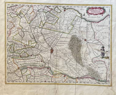
Sold2023The Netherlands Map. The region Around the city of Utrecht. 1660?s by W. BlaeuTitle: The Netherlands Map. The region Around the city of Utrecht. 1660?s by W. Blaeu Date/Period: 1660?s Materials: Hand colored copper plate engraved Size: 22 x 19 1/2'' Netherlands regional map cenSee Sold Price
Sold2017Colton: Antique Map of Netherlands and Belgium, 1861Title/Content of Map: Colton's Netherlands and Belgium Date Printed: 1861 Cartographer: J. H. Colton Material/Medium: Paper Size: 17 1/2" x 13 3/4" Hand colored. Steel engraved. From 'Colton's GeneralSee Sold Price
Sold20241839 Map of Netherlands and Belgium by MoninTitle: 1839 Map of Netherlands and Belgium by Monin Date/Period: 1839 Materials: Hand colored, engraved Size: 17 1/2” x 12 1/2” Netherlands and Belgium with Luxembourg. 1839. By V. Monin.See Sold Price
Sold2018Colton: Antique Map of Netherlands, Belgium, 1859Netherlands, Belgium & Luxembourg with insterst of Brussels & Amsterdam 1859 H.J. Colton 17 1/2" x 15" Hand colored and engraved. Published in New York in Colton's 'General Atlas'. Please note that thSee Sold Price
Sold2021[GREAT LAKES REGION]. ROBERT DE VAUGONDY, Didier[GREAT LAKES REGION]. ROBERT DE VAUGONDY, Didier (1723–1786). Partie De l’Amerique Septent? qui comprend La Nouvelle France ou Le Canada. Paris, 1755. Hand–colored engraved map of eaSee Sold Price
Sold2021[LOW COUNTRIES]. ORTELIUS, Abraham. Descriptio[LOW COUNTRIES]. ORTELIUS, Abraham. Descriptio Germaniae Inferioris. Antwerp, 1572. Text in Latin on verso. Hand–colored engraved map (17 ½ x 21 ½”), detailing the Netherlands, BSee Sold Price
Sold2018Seutter: Antique Map of Belgium & Netherlands, 1740Title/Content of Map: Belgium & Netherlands or the United 17 Provinces Date Printed: c1740 Cartographer: Matthaus Seutter Material/Medium: Paper Size: 19" x 23" Original hand colored copperplate engraSee Sold Price
Sold2018Friesland (Netherlands)Reserve Reduced! Title/Content of Map: Friesland (Netherlands) Date: 1690’s Size: 21x24” By P. Mortier. Amsterdam. Hand colored. Reserve: $75.00 Jasper52 negotiates the lowest reserves so biddersSee Sold Price
Sold2016An Accurate Map of the Netherlands. Europa. 1773.Copper engraving, hand colored print titled, “A New and Accurate Map of the Netherlands from the Sieur Roberts Atlas with Improvements“. Drawn by G.Rollos. Engraved by J. Gibson.Published in FennSee Sold Price
2022Blaeu, Johannes (Netherlands, 1596-1673) "The New World Map" Double Hemisphere World Map C. 1664Nova et Accuratissima Totius Terrarum Orbis Tabula Translated "The New World Map", Hand Colored w/ Elaborately Decorated Spandrels.   Sight View 16" x 21-1/2", Overall View 21" x 25-1/2"See Sold Price
Sold2020Hand colored copper engraved map by Homann, 1715Johann Baptist Homann (German, 1664-1724), hand colored copper engraved map, 1715, 'Provinciae XVII Infer. Germaniae,' depicting the Netherlands, Belgium, and Luxembourg in addition to parts of FranceSee Sold Price
Sold2021BLAEU, Willem Europa Recens Descripta. The Netherlands,BLAEU, Willem Europa Recens Descripta. The Netherlands, 1617. A 20th century facsimile of a later impression of the third state of the original, 1617 map. Hand colored with decorative borders after thSee Sold Price
Sold202417th Century Map of the Netherlands Area, by J. Blaeu,hand colored, circa 1650, approx. 16" X 20" plus mat and frame. Well known retailers tag, see photosSee Sold Price
Jun 01Trillium Antique Prints & Rare BooksBraun & Hogenberg, pub. 1575 - View of Delft, Netherlands$100
2 days LeftArarity AuctionsThomson's 1817 Hand Colored Map Comparative Heights of the World's Great Mountains$50
Jun 09Worthington GalleriesFirst Edition Hand-colored Map THE NORTH RIDING OF YORKSHIRE by Robert Morden$50
Jun 08Early American History Auctions1836 Hand-Colored Map, Country Twenty Five Miles Round The City Of New-York Published by D.S. Stone$260
Jun 08Early American History Auctions1776 Map, PARTIE ORIENTALE DU CANADA, AVEC LA NOUVELLE ANGLETERRE, L'ACADIE... by P. Santini, Framed$950


![Antique French Copper Engraved Colored Map, Amsterdam: 18th century antique French copper engraved and hand colored maps of Amsterdam, Netherlands titled "Lemouicum, Auctore Jo. Faiano M.L. - Lymosin [on sheet with] Topographia Limaniae, Auctore Gabriele](https://p1.liveauctioneers.com/6377/128239/65869733_1_x.jpg?height=310&quality=70&version=1540604375)


![[GREAT LAKES REGION]. ROBERT DE VAUGONDY, Didier: [GREAT LAKES REGION]. ROBERT DE VAUGONDY, Didier (1723–1786). Partie De l’Amerique Septent? qui comprend La Nouvelle France ou Le Canada. Paris, 1755. Hand–colored engraved map of ea](https://p1.liveauctioneers.com/928/212515/108628837_1_x.jpg?height=310&quality=70&version=1627420959)
![[LOW COUNTRIES]. ORTELIUS, Abraham. Descriptio: [LOW COUNTRIES]. ORTELIUS, Abraham. Descriptio Germaniae Inferioris. Antwerp, 1572. Text in Latin on verso. Hand–colored engraved map (17 ½ x 21 ½”), detailing the Netherlands, B](https://p1.liveauctioneers.com/928/222494/114617134_1_x.jpg?height=310&quality=70&version=1634568084)


