Sold20181778 Engraved Map of North American by ZattaAntonio Zatta (1757-87), Italy. The piece is well-executed and detailed showing details of the United States and Canada. Good overall condition. Sight size: H13 1/8" W18 3/4" (without the frame)See Sold Price
Sold2016Hand Colored Engraved Map,Hubert JaillotAfter Hubert Jaillot (1632-1712) "Amerique Septentrionale divisee on ses principales parties". Hand colored engraved map of North American under the French power of Louis XIV. [Sight: 22 1/2" H x 35"See Sold Price
Sold2022(CALIFORNIA AS AN ISLAND.) Joannes Ribbius; and Nicolas Sanson. Audience de Guadalajara, Nouveau(CALIFORNIA AS AN ISLAND.) Joannes Ribbius; and Nicolas Sanson. Audience de Guadalajara, Nouveau Mexique, Californie, &c. Small double-page engraved map of the North American southwest showing CaliforSee Sold Price
Sold2020BOWEN, EMANUEL. An Accurate Map of the West Indies.BOWEN, EMANUEL. An Accurate Map of the West Indies. Double-page engraved map of the North American southeast, Mexico, Central America, and the Caribbean with anecdotal text passages and allegorical fiSee Sold Price
Sold2018Mitchell Map of North America, 1850Excellent hand colored, engraved map of the North American continent originally created by S. Augustus Mitchell in 1850. Thomas, Cowperthwait & Co. bought out Mitchell that year. They published this mSee Sold Price
Sold2023Framed Engraved Map of Eastern US by E. Jones 1805Featured in this lot is this original 1805 E. Jones engraved map showing the United States from Maine to Georgia (Florida is cut off) and west to the Mississippi. The map was engraved by E. Jones, andSee Sold Price
Sold2023Barclay, James 1808 Antique Map. North America - USA Canada"North American from the best Authorities" by Scarce issue Engraved by Lawson, Halifax. Copper Engraved Map Published 1806, London for "Barclay's Complete and Universal English Dictionary" by the Rev.See Sold Price
Sold202418th C. History of United Brethren Mission"History of the Mission of the United Brethren" by G.H. Loskiel, 1794. First Edition. Main source for knowledge on North Americans in the 18th C., with large engraved map. 19in tall x 17-1/4in wide. |See Sold Price
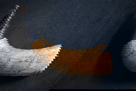
Sold2023Powder Horn with a very detailed map engraved of Northern Illinois and Eastern Iowa. Also hasPowder Horn with a very detailed map engraved of Northern Illinois and Eastern Iowa. Also has Harold Smith engraved in it.See Sold Price
Sold2022ZATTA, ANTONIO. America Settentrionale Divisa ne Suoi Principali Stati.ZATTA, ANTONIO. America Settentrionale Divisa ne Suoi Principali Stati. Double-page engraved map of North America. 15x20¼ inches sheet size, wide margins; original hand-color in outline; minor biSee Sold Price
Sold2022Two Victor Levasseur Maps of the AmericasAmerique Septentrionale, 12 1/4" x 17 1/2" (sight) color engraved map of North America and Amerique Meridionale, 13" x 19 3/8" (sheet) engraved map of South American both from Atlas Universel IllustreSee Sold Price
Sold2016Map, North America, Tallis, C. 1850This engraved map of North America from 1850 includes illustration taking the form of nine vignettes: Esquimaux Dog-Sledge, Cossacks, Wapiti Deer, North American Indians, Ancient Monument in Mexico, CSee Sold Price
Sold20221765 Atlas Map of North + South AMERICA, ExpillyHistoric Maps 1765 Atlas Map of North and South AMERICA by Expilly 1765 Copper Engraved Atlas Map of North and South AMERICA titled, "AMERIQUE Septentrionale et Meridionale," from Le Geographe ManuelSee Sold Price
Sold2022(AMERICAN SOUTHEAST.) Herman Moll. Carolina.(AMERICAN SOUTHEAST.) Herman Moll. Carolina. Engraved map of colonial North America from St. Augustine to the Chesapeake Bay. 8½x12 inches sheet size, ample margins; minor closure at upper edge,See Sold Price
Sold2023(3) Antique North American Maps incl Indian NationsA group of three (3) antique maps of North America, one being a colored depiction of the eastern United States stretching from the east coast to the borders of present day Texas engraved by Gray & SonSee Sold Price
Sold2021Russell, William 1778 Rare Map. North Part of PeruCopper Engraved Map Published 1778, London for "The History of America, From Its Discovery by Columbus to the Conclusion of the Late War" by William Russell. Engraved by John Lodge. Rare. Paper Size:See Sold Price
Sold20221770 MAP OF THE AMERICAS By ANTONIO ZATTAHistoric Maps Hand-Colored MAP OF THE AMERICAS, "L'America divisa Ne Suoi Principali Stati Di Nuova Projesione" by Antonio Zatta 1770 Hand-Colored Engraved MAP OF THE AMERICAS titled, "L'America divisSee Sold Price
Sold2022Rare Ide's Map Of Missoula, Montana City 1891Featured in this lot we have a rare large map of Missoula Montana, 1891. Compiled and drawn by Kennedy & Powell Civil and mining engineers in Missoula, engraved by J.L. Smith, Philadelphia, PA. (as wrSee Sold Price
Sold2018North & South America in 1776Heading: Author: Zatta, Antonio Title: L'America Divisa ne suoi Principali Stati di Nuova Projezione... Place Published: Venice Publisher: Date Published: 1776 Description:See Sold Price
Sold2022Hughes, W. C1840 Map of the North East USA"The North Eastern Part of the United States" Steel Engraved Map Published C1840 by Virtue, London for "American Scenery..." by N. P. Willis, Illustrated by William Henry Bartlett. Drawn & Engraved bySee Sold Price
Sold2021Antique MapsGrouping of Two (2) Antique Engraved Maps. Includes a T. Kitchin map of British Dominions in North America along with Eman Bowen map of British American Plantations. Largest frame measures 16" x 18".See Sold Price
Sold2023Maps of North/South Carolina, Charleston HarborMap of North and South Carolina engraved and printed by Ferrier Sears & Co., published by J.T. Hinton, Simpkin & Marshall, 1832..Charleston Harbor Map, engraved for The American Coast Pilot, 14th editSee Sold Price
Sold2018New Map of North America Shewing All the NewTitle/Content of Map: New Map of North America Shewing All the New Discoveries 1797. Date: 1797 Cartographer: CALLENDER, Sc. Size: 7.6X9 "Engraved for Morse's American Gazetteer. Hill Sct." Few marginSee Sold Price
Sold2018New Map of North America Shewing All the NewTitle/Content of Map: New Map of North America Shewing All the New Discoveries 1797. Date Printed: 1797 Cartographer: CALLENDER, Sc. Size: 7.6X9 "Engraved for Morse's American Gazetteer. Hill Sct." WaSee Sold Price
Jun 08Early American History Auctions1853 Map, Basin of the St. Lawrence, by T. Keefer showing Natural + Artificial North American Routes$220
Jun 07Freeman's | HindmanHOMANN, Johann Baptist. Amplissimae Regionis Mississipi Seu Provinciae Ludovicianae. Nuremburg, [ca$400(1 bid)
Jun 08Early American History Auctions1853 Map of Portion of British North America and Gulf of St. Lawrence, by Henry Perley$260
Jun 14DuMouchellesWilliam Barker (American, 1770-1805) And Various Engravers Hand Colored Engraved Maps Ca. 18th/19th$50
Jun 07Freeman's | HindmanHARMON, Daniel Williams. A Journal of Voyages and Travels in the Interiour of North America. 1820.$450(2 bids)
Jun 09Worthington GalleriesFirst Edition Hand-colored Map THE NORTH RIDING OF YORKSHIRE by Robert Morden$50
Jun 08Early American History Auctions1753 Map of the County of Lancaster Divided into its Hundreds, by Royal Mapmaker Emanuel Bowen$280
7 days LeftRbfineartsHistorical Map of the State of Kentucky by Karl Smith 1933 Daniel Boone & Companions View$30(2 bids)
Jun 07Freeman's | HindmanMICHAUX, François André and Thomas NUTTALL. The North American Sylva...1852-1853. Later$1,000
7 days LeftRbfineartsHistorical Map of the Chesapeake Bay By Edwin Tunis Published By The National Brewing Co.$20(1 bid)
7 days LeftLink Auction GalleriesStuder, Jacob H.: The birds of North America. drawn and colored from nature including a copious$75
2 days LeftA.H. Wilkens Auctions & AppraisalsCHIEF OF POLICE SILVER BADGE, 19th C LONDONCA$300(1 bid)