Sold20231759 Tirion Map of the Americas -- Nieuwe Kaart van America…Title: 1759 Tirion Map of the Americas -- Nieuwe Kaart van America… Cartographer: I Tirion Year / Place: 1759 c., Amsterdam Map Dimension (in.): 10.8 X 12.5 in. This is wonderful map of the AmerSee Sold Price
Sold20231755 Tirion Map of Eastern North America -- Nieuwe Kaart van de Grootbrittannische Volkplantingen inTitle: 1755 Tirion Map of Eastern North America -- Nieuwe Kaart van de Grootbrittannische Volkplantingen in Noord America Cartographer: I Tirion Year / Place: 1755, Amsterdam Map Dimension (in.): 14.3See Sold Price
Sold2019Isaak Tirion (1705-1765, Amsterdam), "Nieuwe Kaart vanIsaak Tirion (1705-1765, Amsterdam), "Nieuwe Kaart van America," 1766, hand colored, H. - 12 in., W. - 13 in.See Sold Price
Sold2016Map, Isaak Tirion, Nieuwe Kaart Van EuropaIsaak Tirion (Dutch, 1705-1765), "Nieuwe Kaart Van Europa," hand-colored copper engraving, overall (with frame): 19"h x 21"wSee Sold Price
Sold2019Map of England & Wales 1760Heading: (Maps) Author: Tirion, Isaac Title: Nieuwe Kaart van 't Zuider Gedeelte van Groot Britannie behelzende Het Koningryk Engeland… Place Published: Amsterdam Publisher: Date Published: 1See Sold Price
Sold2017Moll / Oldmixon: Antique Map of North America, 1721Map: Nieuwe Kaart van Noord Amerika Cartographer: H. Moll / Oldmixon Place & Date: Amsterdam / 1721 Size: 9 3/4" x 6 3/4" Condition: outline color; overall age toning and minor spotting In this DutchSee Sold Price
Sold2017Tirion: Antique Map of the Western Hemisphere, 1754Map: Nieuwe Kaart van het Westelykste Deel der Wereeld Cartographer: Isaac Tirion Place & Date: Amsterdam / 1754 Size: 14 1/4" x 13 1/4" Condition: wash color; light overall age toning; backed to reinSee Sold Price
Sold2021Tirion 1733 Map of AsiaDESCRIPTION: Map by Isaac Tirion, engraved by Jacob Keyser. Titled "Nieuwe Kaart van Asia na de alderlaatste Ontdekking int licht gebracht." Depicts Japan, Kamchatka Peninsula, Australia's northern coSee Sold Price
Sold2023MAP, Malta, TirionMalta. Isaac Tirion, Nieuwe Kaart van't Eiland Maltha met Gozo en Comino..., from Nieuwe en Beknopte Hand Atlas, 1761 (dated). Hand Color. Handsome, large map of the Maltese Islands with superb detailSee Sold Price
Sold2017An antique map of Poland by Izaak Tirion, circa 1740An antique map of Poland by Izaak Tirion, circa 1740 Title: [Old Antique map of Poland / Lithuania] Nieuwe Kaart van het Koninkryk Poolen. Author: Tirion, Izaak , Amsterdam, c. 1740. DescriSee Sold Price
Sold2017MAP, C. 1750, INDIA & SOUTHEAST ASIA, ISAAK TIRIONFramed map of India an nearby countries, "Nieuwe Kaart van India over de Ganges of van Malakka, Siam, Cambodia, Chiampa, Kochinchina, Laos, Pegu, Ava" c. 1750 by Issak Tirion (Dutch, 1705-1765), handSee Sold Price
Sold2019India.- Tirion (Isaac) Nieuwe Kaart van t Keyzer RykIndia.- Tirion (Isaac) Nieuwe Kaart van t Keyzer Ryk van den Grooten Mogol, map of The Mughal Empire, which included India, Sri Lanka, Pakistan and Bangladesh, engraved map with hand-colouring on laidSee Sold Price
Sold20221687 Keulen Map of North and South America's Mostly Atlantic Coastal Areas -- Pas Kaart van WestTitle: 1687 Keulen Map of North and South America's Mostly Atlantic Coastal Areas -- Pas Kaart van West Indien Behelsende soo Deszelffs Vaste Kusten als d'Onder Behoorende Eylanden aan de Noord OceaanSee Sold Price
Sold2019Isaak Tirion (1705-1765, Amsterdam), "Nieuwe Kaart vanIsaak Tirion (1705-1765, Amsterdam), "Nieuwe Kaart van Arabia,"18th c., hand colored, H. - 15 in., W. - 18 in.See Sold Price
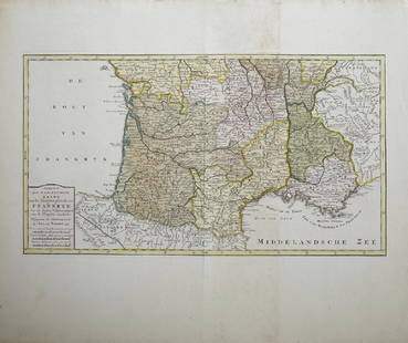
Sold2019Isaak Tirion (1705-1765, Amsterdam), "Nieuwe Kaart vanIsaak Tirion (1705-1765, Amsterdam), "Nieuwe Kaart van het Zuidelykste Gedeltevan Frankryk," 1757, hand colored, H. - 16 7/8 in., W. - 20 7/8 in.See Sold Price
Sold2019Isaak Tirion (1705-1765, Amsterdam), "Nieuwe Kaart vanIsaak Tirion (1705-1765, Amsterdam), "Nieuwe Kaart van Frankryk," hand colored, H. - 17 in., W. -20 1/2 in.See Sold Price
Sold2019Emanuel Bowen (1693-1767, "Nieuwe en Algemeene KaartEmanuel Bowen (1693-1767, "Nieuwe en Algemeene Kaart van America, Getrokken mil. Landkarten," 1783, hand colored, H.- 18 1/2 in., W.- 23 in.See Sold Price
Sold2018van Keulen: Antique Map Guadeloupe & Marie Galante 1720Title/Content of Map: Nieuwe Land en Zee Kaart van de Eylanden Guadalupe en Mariegalande Cartographer: van Keulen Place & Date: Amsterdam / 1720/1780 Size: 22 1/2" x 19 7/8" Condition: b&w; overall agSee Sold Price
Sold2024Military Costume Print LotVarious antique and vintage prints, including French military dress. Also battle scene views, Nieuwe Kaart map by Isaac Tirion, etc. Condition varies.See Sold Price
Sold2022Map of Suriname – 18th Century – With Notation ofNieuwe Kaart van Suriname vertonende de stromen en land-streken van Suriname, Comowini, Cottica, en Marawini. Map of Suriname, hand-colored. Amsterdam: J. Ottens, [early 18th century].A detailed map oSee Sold Price
Sold2017Tirion: Antique Map of Isthmus of Panama, 1750Map: Kaart van de Landengte van Panama (Isthmus of Panama) Cartographer: Tirion Place & Date: Amsterdam / 1750 Size: 11 7/8" x 10 5/8" Condition: wash color; light overall age toning A beautifully desSee Sold Price
Sold2017Tirion: Antique Map of Panama, 1750Map: Kaart van de Landengte van Panama Cartographer: Tirion Place & Date: Amsterdam / 1750 Size: 11 7/8" x 10 5/8" Condition: b&w; overall age toning and minor spotting A beautifully designed and highSee Sold Price
Sold2019Tirion: Todos os Santos Bay, Brazil, with Salvador PlanMap Title: Kaart van de Aller-Heiligen Baay waar aan de Hoofdstad Legt van Brazil Cartographer: Tirion Place / Date: Amsterdam / 1767 Size: 15 1/2" x 13 1/2" Condition: wash color; light overall age tSee Sold Price
Sold2018van Keulen: Southern Hispaniola/Northern South AmericaMap Title: Pas-kaart Van de Zuyd-Kust van Espanjola. Cartographer: van Keulen Place & Date: Amsterdam / 1682 Size: 23" x 20" Condition: outline color (wash in cartouche); top margin trimmed close; ligSee Sold Price
Jun 13Swann Auction Galleries(AMERICAS.) Group of 6 seventeenth-to-eighteenth-century engraved maps of the Western Hemisphere.$1,100
Jun 13Swann Auction Galleries(NORTH AMERICA.) Group of 4 seventeenth-to-eighteenth-century engraved maps.$500
5 days LeftEarly American History Auctionsc 1730 Hand-Colored Colonial Era Map of the Americas, California shown as an Island, Matted + Framed$500(1 bid)
1 day LeftJasper52Cincinnati and Environs. Rand, McNally & Co's New Business Atlas of America Map of Cincinnati.$40
4 days LeftFreeman's | Hindman[MAP]. TODESCHI, Pietro. [Nova et Acurata Totius Americae Tabula auct. G.I. Blaeu] America quarta$5,000
Featured1 day LeftJasper521831 Woodbridge Map of South America and Africa -- Comparative, Geographical & Statistical Map of$70(1 bid)
5 days LeftTrillium Antique Prints & Rare BooksSanson - Map of North America with California as an Island$120(3 bids)


![An antique map of Poland by Izaak Tirion, circa 1740: An antique map of Poland by Izaak Tirion, circa 1740 Title: [Old Antique map of Poland / Lithuania] Nieuwe Kaart van het Koninkryk Poolen. Author: Tirion, Izaak , Amsterdam, c. 1740. Descri](https://p1.liveauctioneers.com/6018/113868/58519818_1_x.jpg?height=310&quality=70&version=1513369839)


![Map of Suriname – 18th Century – With Notation of: Nieuwe Kaart van Suriname vertonende de stromen en land-streken van Suriname, Comowini, Cottica, en Marawini. Map of Suriname, hand-colored. Amsterdam: J. Ottens, [early 18th century].A detailed map o](https://p1.liveauctioneers.com/3506/232707/120467405_1_x.jpg?height=310&quality=70&version=1641394058)


![[MAP]. TODESCHI, Pietro. [Nova et Acurata Totius Americae Tabula auct. G.I. Blaeu] America quarta (1 of 1)](https://p1.liveauctioneers.com/197/329395/177650542_1_x.jpg?height=282&quality=70&version=1715364962)


![British Plantation Map of the Americas [179303] (1 of 1)](https://p1.liveauctioneers.com/2699/331495/178785748_1_x.jpg?height=282&quality=70&version=1717094933)

![Jacob Monk 1853 Map of North America [173506] (1 of 11)](https://p1.liveauctioneers.com/2699/331495/178785775_1_x.jpg?height=282&quality=70&version=1717094933)