Sold20181759 Magazine Surrender of Guadalope w/ MapThe June 1759 issue of Gentleman’s Magazine printed at London with accounts of the taking of the Island of Guadaloupe with the Articles of Capitulation. ALSO an engraved map. Other articles as wellSee Sold Price
Sold20171759 Gentleman's Magazine Prussian war w/ Maps Plan1759 Gentleman's Magazine Prussian war w/ Maps Plan Deaf Chair. “Gentleman’s Magazine for August 1759, complete, 48 pages and three engravings: one a map of Westphalia, another of troop formationSee Sold Price
Sold20171759 Magazine French Indian War With Map1759 Magazine French Indian War w/ Map Of Crown Point Ticonderoga. May 1759 issue of Gentleman’s Magazine printed in London, 48 pages. French Indian War content including a map of the Country betweeSee Sold Price
Sold20171759 Magazine French Indian War With Folding Maps1759 Magazine French Indian War W/ Map Martinico. The March 1759 issue of “Gentleman’s Magazine”, printed at London, 52 pages. French Indian War treaties with the Indian tribes of North America,See Sold Price
Sold20181744 Volume of Gentleman's Magazine w/ MapVOLUME of Gentleman’s Magazine for the Year 1744 with twelve monthly issues and index. The January issue is incomplete beginning on page 8, else complete including map of Austrian and French NetherlSee Sold Price
Sold20191740 Magazine w/ Map Vera CruzThe May 1740 issue of Gentleman’s Magazine 56 pages including a small folding map of the port of Vera Cruz in New Spaine. Also description of the West Indies Islands with brief descriptions of JamaiSee Sold Price
Sold20181764 Magazine w/ Map of ItalyThe September 1764 issue of Gentleman's Magazine printed in London, complete including a Map of Italy relating to the royal tour by the Duke of York. The map accompanied by an article on the trip. MucSee Sold Price
Sold20171759 Gentleman's Magazine w/ EngravingsThe December 1759 issue of "Gentleman's Magazine", printed at London, two engraved plates including Tattershall Castle and of a Mermaid "drawn from life". Interesting articles including of a General PSee Sold Price
Sold20171759 Magazine French Indian War Map of Quebec1759 Magazine French Indian War Map of Quebec. The October 1759 issue of Gentleman's Magazine, printed in London, 54 pages. INCLUDES the exact map of the "Isle of Orleans and the Country Round Quebec"See Sold Price
Sold20181774 Gemtleman's Magazine 1st Ed w/ Road MapIn it's ORIGINAL blue advertising wrapper, the "Supplement to the Gentleman's Magazine For the Year 1774", printed in London. 28 pages plus index for the year. Also a folding plate of a road map fromSee Sold Price
2016Guadaloupe, London Magazine 1759Title: Guadaloupe, one of the Caribbee Islands Subject: Guadaloupe Maker: London Magazine Date: 1759, London Magazine: London Size: 7.25 x 8.75 inches French & Indian War-period map of the island thatSee Sold Price
Sold20171759 Map Seat of War on Rhine1759 Map Seat of War on Rhine 1759 “Map of the Seat of War on the Rhine”, printed for Gentleman’s Magazine, folding map measures 11 x 8”, Fine. Please note that this lot has a confidential resSee Sold Price
Sold2018Mexico C. America, W. Indies Map 1939National Geographic magazine map: Mexico, Central America and the West Indies. Editor: Gilbert Grosvenor. Date: 1939. Measurement approximate: 41 x 23. Shipping cost: $15.00 excluding Hawaii, Alaska &See Sold Price
Sold2017Map Plan of Roads of Toulon, 1759A map plan of "The Roads of Toulon with the adjacent Country", printed in 1759 for Gentleman's Magazine (Jolly Gent127). Fine condition, folds as issued. Measures 11.25 x 8". No Reserve: This lot starSee Sold Price
Sold2017River St. Laurence, Sillery-Falls of Montmorency MapAn Authentic Plan of the River St. Laurence (Lawrence) from Sillery to the Falls of Montmorency, Gibson, John, Gentleman's Magazine, 1st Edition, 1759, Original black ink engraving with hand-coloring.See Sold Price
Sold20171759 Map of Present State of War in Germany1759 Map of Germany “A Compleat Map of Germany Comprehending in One View the Seats of the Present War 1759”, printed for Gentleman’s Magazine, measures 13.5 x 12”. Please note that this lot haSee Sold Price
Sold2020Bowen, Emmanuel 1760 Hand Col Map of Staffordshire, UKHand Colored Copper Engraved Map Published 1755-65 by W. Owen, London for "The General Magazine of Arts & Sciences" Edited by Benjamin Owen. Map by Emmanuel Bowen. Paper Size: 8.5 x 5 inch (22 x 13cm)See Sold Price
Sold2020Wendell August Aluminum Magazine Rack. North America MaWendell August Aluminum Magazine Rack. North America Map. -- Dimensions: H: 12 inches: W: 12 inches: D: 5 inches ---See Sold Price
Sold2022Arts and Craft Wrought Iron and Wood Magazine RackDecorated with a map of Illinois. Sold as is. 17"w x 9.5"d x 19"hSee Sold Price
Sold2020Gentleman's Mag 1759 Map. Westphalia, Germany"A Map of that Part of Westphalia, in which the French Army where defeated Aug. 1. 1759" Copper Engraved Map Published London 1731-1833, London for "The Gentleman's Magazine..." by Various ContributorSee Sold Price
Sold2022Gentleman's Mag 1759 Map. Westphalia, Germany"A Map of that Part of Westphalia, in which the French Army where defeated Aug. 1. 1759" Copper Engraved Map Published London 1731-1833, London for "The Gentleman's Magazine..." by Various ContributorSee Sold Price
Sold2021Gentleman's Mag 1759 Map. Westphalia, Germany"A Map of that Part of Westphalia, in which the French Army where defeated Aug. 1. 1759" Copper Engraved Map Published London 1731-1833, London for "The Gentleman's Magazine..." by Various ContributorSee Sold Price
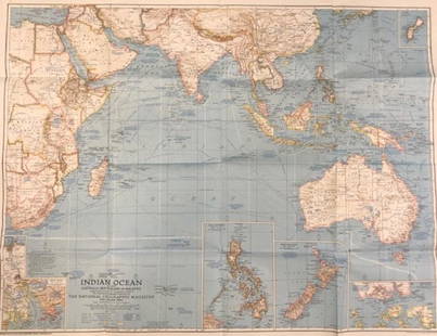
Sold2020Vintage National Geographic Magazine map of the IndianDescription: Vintage color paper map from National Geographic Magazine depicting the Indian Ocean. Copyright 1941. Material: paper. Measurement: approximate 26.5"h x 34"w (INCHES). Shipping cost: $12;See Sold Price
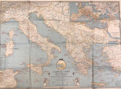
Sold2020Vintage National Geographic MagazineDescription: Vintage paper map from National Geographic Magazine, depicting the classical lands of the Mediterranean. Copyright 1940. Material: paper. Measurement: approximate 26.5"h x 34"w (INCHES).See Sold Price
Featured11 hrs LeftJasper521759 HISTORY OF THE WORLD in GERMAN antique ILLUSTRATED w/ MAP of ARABIA vellum$200
Echoes of Glory International Military Auction HouseRussian PPS-43 Magazine Pouch w/ Magazines (LPT)$45(17 bids)
Jun 14DuMouchellesWilliam H. Gamble (American, B. 1863) Hand Colored Engraving, Ca. 1863, "County Map of Michigan And$50(1 bid)
Jun 14DuMouchellesChris-Craft (American) Mixed Media Drawing on Paper Ca. 1944, "Original Advertising Art, Life$600
Jun 07Freeman's | Hindman[FRANKLIN PRINTING] -- [GALLOWAY, Joseph]. A True and Impartial State Of the Province of$250(1 bid)
Jun 14DuMouchellesRigobert Bonne (French, 1727-1794) Hand Colored Engraving Ca. 18th Century, Les Etats Unis De$50
Jun 14DuMouchellesChris-Craft (American) Mixed Media Drawing on Paper Ca. 1940's, "Original Advertising Art, Life$600
5 days LeftGold Coast Auctioneers17th-19th c. French Wall Art Collection Map City Sea Scapes Scenes etc.$50
4 days LeftRipley AuctionsArt Nouveau / Early 20th Century Halloween postcard or magazine original illustration$140(2 bids)


![[FRANKLIN PRINTING] -- [GALLOWAY, Joseph]. A True and Impartial State Of the Province of (1 of 1)](https://p1.liveauctioneers.com/197/329395/177650554_1_x.jpg?height=282&quality=70&version=1715364962)


