Sold20181748 Folding Plan of Aix La Chapelle1748 folding plan of "Aix La Chapelle", originally printed in Gentleman’s Magazine, Very Good, measures 9 x 11". Please note that this lot has a confidential reserve. When you leave a bid in advanceSee Sold Price
Sold2022American Colonial Interest and Germany. A Very Rare 1748 Treaty of Aix-la-Chapelle (sometimes calledAmerican Colonial Interest and Germany. A Very Rare 1748 Treaty of Aix-la-Chapelle (sometimes called the Treaty of Aachen) Medal (Bronze, 45mm, 34.3 grams). Menadier-42, Pax-565. This particular medalSee Sold Price
Sold2022Great Britain. 1748 Peace of Aix-La-Chapelle (Aachen) Silver Medal by J.C. Marne (33mm, 12.5 grams).Great Britain. 1748 Peace of Aix-La-Chapelle (Aachen) Silver Medal by J.C. Marne (33mm, 12.5 grams). The obverse features Mars advancing on a city carrying a sword and torch; the reverse Pax standingSee Sold Price
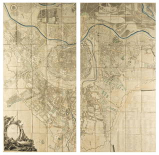
Sold2021Topographical plan of the city of Rome, 1748, by GianTopographical plan of the city of Rome, 1748, by Gian Battista Nolli (Como, 1701-1756). Folding, in sixteen sections, in sixteen sections glued on canvas. 47 x 69 cm. Plano topográfico de la ciudSee Sold Price
Sold20211748 Plan Isle of Macau ChinaCirca 1748 Plan De La Ville Et Du port De Macao by Jacques Bellin. Printed at Paris. Fine condition, measures 7.5 x 10". Reserve: $80.00 Shipping: Domestic: Flat-rate of $6.00 to anywhere within the cSee Sold Price
Sold2016GERARD, publisher. Collection de douze vues de Waterloo[Collection de douze vues de Waterloo]. [Brussells: Gerard, c1845]. Oblong. Colored views of Waterloo and large folding map "Plan de la bataille de Waterloo 18 Juin 1815". Oblong fSee Sold Price
Sold2022La Chapelle (Vincent) The modern cook's, and complete housewife's companion, fourth edition, PrintedLa Chapelle (Vincent) The Modern cook's, and complete housewife's companion, fourth edition, 5 (of 6) engraved folding bills of fare (lacking the first), bills of fare 3-5 closely trimmed at head, witSee Sold Price
Sold20231762 Handcolored Engraving Russian FortressHandcolored "Plan De La Forteresse De Tobolsk", nu Jacques Bellin, printed circa 1762 at Paris. Measures 7.25 x 6.5". Folding map. Reserve: $40.00 Shipping: Domestic: Flat-rate of $8.00 to anywhere wiSee Sold Price
Sold2018Battle of Aspern-Essling 1809. Vienna Austria. War ofTITLE/CONTENT OF MAP: 'Plan de la Bataille D'essling' DATE PRINTED: 1820 IMAGE SIZE: Approx 18.5 x 22.5cm, 7.25 x 8.75 inches (Medium); Please note that this is a folding map. TYPE: Antique copperplatSee Sold Price
Sold2024DE BOSRAGER. Militaria. Principes de..Guerre 1779Militaria.- [LE ROY de Bosrager]. Principes de l’Art de la Guerre. Paris: 1779. Octavo. 8 folding engraved plans. Mottled calf, spine gilt (spine and extremities worn). Provenance: King Lawrence ParSee Sold Price
Sold20191748 Plan of MaestrichtA folding “New and Correct Plan of the City and Fortifications of Maestricht”, by T. Jefferys, London, 1748. Very Good, crease along one fold. Measures 9x 7.5”. Reserve: $20.00 Shipping: DomestiSee Sold Price
Sold2019Baedeker, Karl 1898 Guide Book, N. W. France, 25 Maps"Le Nord-Ouest de La France" by Karl Baedeker. 12mo (160 x 110mm) Leipzig & Paris: Karl Beideker & Paul Ollendorff. Red Cloth. Containing approx 25 (of 30) Maps and Plans, several pull-out folding. WaSee Sold Price
Sold2021Thailand.- La Loubère (Simon de) Du royaume deThailand.- La Loubère (Simon de) Du royaume de Siam, 2 vol., titles with woodcut printers device, 2 folding engraved maps, 38 plates and plans (2 with explanation f. opposite), some folding, occaSee Sold Price
Sold2024David LaChapelle - Francis Bean Cobain for Rolling Stones - Signed by David La Chapelle with COA40x30 cm - Signed by DLC - with COASee Sold Price
Sold2022DAVID LACHAPELLE (*1963)DAVID LACHAPELLE (*1963) | ‘Early Fall’, Los Angeles 2008–2011 | Chromogenic print, Alu-dibond mounted, in original frame with shadow gap 110 x 74,5 cm, in excellent condition From tSee Sold Price
Sold2021Jean Cocteau (1889-1963)Jean Cocteau (1889-1963) Deux anges à la trompette - étude pour la décoration de la Chapelle Notre-Dame de Jérusalem de Fréjus 1962-63 pencil on paper, unsigned 10 1/2 x 8 1/4See Sold Price
Sold2021World Views C1840-60 Lot of 40 Steel EngravingsLot of Steel Engraved Views. Incl Amalfi, Tangiers, Baden Baden, Rouen, Strasburg, Abbeville, Aix-la-Chappelle, Prague, Stoke Pogis, Newcastle, St. Pauls Cathedral, Kenilworth, British Coal Mines, ThuSee Sold Price
Sold2018Austria.- Grimm (Maximilian von) Grundriss der Kl: Kl:Austria.- Grimm (Maximilian von) Grundriss der Kl: Kl: Haupt und Residenzstadt Wien mit ihren Vorstadten nach den Neuen Hausnumern 1797 / Plan de la Ville de Vienne et de ses Fouxbourgs avec le DenombSee Sold Price
Sold2021Jacques Nicolas Bellin MapsJacques Nicolas Bellin , "Plan de La Nouvelle Orleans" and "Carte des Embouchures du Mississipi", two hand-colored engraved maps, from Le Petit Atlas Maritime, 1764, 7 1/2 in. x 11 in., framed . ProveSee Sold Price
Sold202119th Century Map of MemphisPLAN DE LA VILLE DE MEMPHIS (ETATS-UNIS) 40,000 HABITANTS pen and ink with watercolor hand drawn drainage system map, circa 1870. Depicts a grid street plan of the city of Memphis with labeled streetSee Sold Price
Sold2022SARTINE, ANTOINE DE Carte d'une partie des côtes de la Floride et de la Louisiane, contenant leSARTINE, ANTOINE DE Carte d'une partie des côtes de la Floride et de la Louisiane, contenant le cours du Mississipi, depuis ses... [Paris: Dépôt des Cartes et Plans de la Marine], 1778.See Sold Price
Sold2024Bligh, Mutiny on the Bounty, 1790Bligh, William. A NARRATIVE OF THE MUTINY ON BOARD HIS MAJESTY'S SHIP BOUNTY…. London: George Nicol, 1790. 4to. iv, 88 pp. + 4 total engraved plates, including 1 folding engraved frontis plan of theSee Sold Price
Sold2021Nelson at Trafalgar.- A Plan of the Attack by LordNelson at Trafalgar.- Collingwood (Cuthbert, Baron Collingwood, naval officer, 1748-1810) A Plan of the Attack by Lord Nelson of the Combined Fleet, October 21st, 1805, printed newspaper broadside witSee Sold Price
Sold2020Main plans, ports, and harbors of the MediterraneanHeading: Author: Roux, Joseph Title: Receuil sic des principaux plans, des ports, et rades de la Mer Mediterranée Place Published: Marseille Publisher:Joseph Roux et Fils Date Published: 176See Sold Price
19 hrs LeftJasper52Suite de la Coste de Guinée'. Ghana Togo Benin coast. BELLIN/SCHLEY 1748 map$30
BonhamsMANDELSLO (JEAN-ALBERT DE) Voyages célèbres & remarquables, Faits de Perse aux Indes o...£1,000
BonhamsGRANDPRE (LOUIS DE) Voyage a la côte occidentale d'Afrique, fait dans les annees 1786 et 17...£500
2 days LeftRapid Estate Liquidators and Auction GalleryHandcolored Lithograph signed by Artist "Paris, Le Palais de Justice et la Chapelle"$80
2 days LeftFreeman's | Hindman[MAP]. SARTINE, Antoine Plan de la Barre et du Havre de Charles-Town...1778. RARE REVOLUTIONARY WAR$1,000(1 bid)
19 hrs LeftJasper52FRENCH SUDAN (Now Mali). Soudan Français. Bamako city plan de la ville 1938 map$25
19 hrs LeftJasper52FRENCH SUDAN (Now Mali). Soudan Français. Bamako city plan de la ville 1929 map$25
19 hrs LeftJasper52FRENCH SUDAN (Now Mali). Soudan Français. Bamako city plan de la ville 1931 map$25
Jun 13Swann Auction Galleries(AMERICAN REVOLUTION -- YORKTOWN.) Thomas Abernathie, engraver; for David Ramsay. Plan of the$450
BonhamsBOWYER (ROBERT) An Illustrated Record of Important Events in the Annals of Europe, During the La...£800
19 hrs LeftJasper52Carte de la partie septentrionale d'Afrique, ou de la Barbarie… BONNE 1780 map$25
Featured19 hrs LeftJasper52Suite de la Coste de Guinée'. Ghana Togo Benin coast. Whidah. BELLIN 1747 map$30
Jun 13Swann Auction Galleries(MEXICO.) Direccion de Estudios Geograficos y Climatologicos. Atlas Geografico de la Republica$450
19 hrs LeftJasper52Royaumes, Etats et Pays de la Haute Guinée. Gulf of Guinea. BONNE 1788 old map$20


![GERARD, publisher. Collection de douze vues de Waterloo: [Collection de douze vues de Waterloo]. [Brussells: Gerard, c1845]. Oblong. Colored views of Waterloo and large folding map "Plan de la bataille de Waterloo 18 Juin 1815". Oblong f](https://p1.liveauctioneers.com/4473/89380/45682128_1_x.jpg?height=310&quality=70&version=1464303660)


![DE BOSRAGER. Militaria. Principes de..Guerre 1779: Militaria.- [LE ROY de Bosrager]. Principes de l’Art de la Guerre. Paris: 1779. Octavo. 8 folding engraved plans. Mottled calf, spine gilt (spine and extremities worn). Provenance: King Lawrence Par](https://p1.liveauctioneers.com/3975/327539/176427167_1_x.jpg?height=310&quality=70&version=1714063840)


![SARTINE, ANTOINE DE Carte d'une partie des côtes de la Floride et de la Louisiane, contenant le: SARTINE, ANTOINE DE Carte d'une partie des côtes de la Floride et de la Louisiane, contenant le cours du Mississipi, depuis ses... [Paris: Dépôt des Cartes et Plans de la Marine], 1778.](https://p1.liveauctioneers.com/292/250642/130213716_1_x.jpg?height=310&quality=70&version=1654271664)


![[MAP]. SARTINE, Antoine Plan de la Barre et du Havre de Charles-Town...1778. RARE REVOLUTIONARY WAR (1 of 1)](https://p1.liveauctioneers.com/197/329395/177650540_1_x.jpg?height=282&quality=70&version=1715364962)


