Sold20201746 Map by Child of Calbar River in Nigeria -- AnTitle: 1746 Map by Child of Calbar River in Nigeria -- An accurate Map, of Kalbar River, (Commonly called Kalabar or Rio Real) and the Adjacent Coast, drawn on the spot by several Pilots 1699 CartograSee Sold Price
Sold2023The Kingdoms of Kongo, Angola & Benguela'. Congo Gabon. G. CHILD 1746 old mapTITLE/CONTENT OF MAP: 'A Map of the Kingdoms of Kongo, Angola, & Benguela with the adjacent Countries' DATE PRINTED: 1746 IMAGE SIZE: Approx 24.5 x 31.5cm, 9.75 x 12.5 inches (Large); Please note thatSee Sold Price
Sold20231746 Harris Map of Canton/Guangzou -- A Plan of the City of Canton on the River Ta hoTitle: 1746 Harris Map of Canton/Guangzou -- A Plan of the City of Canton on the River Ta ho Cartographer: J Harris Year / Place: 1746 c., London Map Dimension (in.): 12 X 7.9 in. This is a superb earSee Sold Price
Sold2017A Fine old AFO Fertility sculpture African Tribal ArtCarved wooden image of a Mother and her children from the Afo peoples of the Benue river, Northern Nigeria. Beautifully carved with stylized facial treatment, note the tall headdress o the mother andSee Sold Price
Sold20221746 MAP OF THE WESTERN HEMISPHERE By HomannHistoric Maps 1746 MAP of the WESTERN HEMISPHERE by Homann with Cartouche at lower left depicts Native American Indians 1746-Dated, Hand-Colored Engraved MAP OF THE WESTERN HEMISPHERE titled, "AmericaSee Sold Price
Sold2016Yoruba divination cup, first half 20th c.A divination cup with kneeling mother and child. Nigeria, Yoruba. 1st half 20th century. 9"h x 7 1/2"dia. Provenance: Inventory and Collection from the Estate of Merton D. Simpson. Catalog Notes: TheSee Sold Price
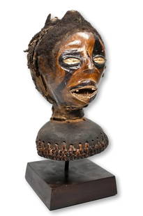
Sold2021A Cross-River MaskMaske Cross-River, Nigeria Mit Sockel / with base Holz. H 61 cm. Provenienz: Nachlass René David (1928-2015), Zürich. Ausgestellt: Musée International du Golfe de Guinée, Togo (2005-2011). HelmmasSee Sold Price
Sold2022[MANUSCRIPT MAP-FLORIDA & MISSISSIPPI RIVER] Map Showing Raiford's Proposed Artificial River and[MANUSCRIPT MAP-FLORIDA & MISSISSIPPI RIVER] Map Showing Raiford's Proposed Artificial River and Plan to Continue the Western and Southern Inland System of Navigation to Harbors in the Atlantic. [FernSee Sold Price
Sold2016Map, Hudson River, Rev. War, Sauthier, 1776At the top of the map is written: "A Topographical Map of Hudsons River, with the Channels Depth of Water, Rocks, Shoals, &c. and the Country Adjacent, from Sandy-Hook, New York and Bay to Fort EdwardSee Sold Price
Sold2021A Mumuye Figure, iagalagana Benue River ValleyA Mumuye Figure, iagalagana Benue River Valley, Nigeria, 20th century Wood with black coloration, remainder of red and white earth pigments in crevices and under chin. Of typical form with front of leSee Sold Price
Sold2024Boki Janus Skin Covered Headdress Ex Constance McCormick FearingThis is a very rare Janus and skin covered headdress Known as Nkuambok, created by the Boki peoples, Cross River region, Nigeria, Africa. The headdress has been embellished with black paints, human haSee Sold Price
Sold2017Homann: Map of the Americas, 1746Map: 1746 Homann Map of the Americas -- Americae Mappa Generalis Secundum Legitimas Projectionis Stereographicae Regulas… Cartographer: J. Homann Year / Place: 1746 Nurnberg Map Dimensions: 19.2 x 2See Sold Price
Sold2016O/C 'Russian Parade' Mochalski, 1949Description: Along the promenade of the Moscow River, Children carrying , a tuba, flags, some wearing military uniforms. The Kremlin is pictured in the background. 'They saw Stalin' History: Dimitri KSee Sold Price
Sold20171746 Homann World MapTitle: 1746 Homann World Map -- Planiglobii Terrestris Mappa Universalis utrumque Hemisphaerium Orient et Occidentale Repraesentans ex IV. Mappis Generalibus ... / Mappe-Monde qui Represente les DeuxSee Sold Price
Sold2021Andre Gisson. French. Large landscape with women andAndre Gisson. French. Large landscape with women and child by a river. Oil on canvas. Framed. Signed lower right. Craquelure in upper left sky. Sight: 24 x 36in. Overall: 33 x 45in.See Sold Price
Sold2016Matched Pair of African Ibibio Ancestral PuppetsWest Africa, Nigeria, Cross River region, Ibibio culture, ca. early to mid 20th century CE. A matched pair of hand-carved wooden ancestral puppets with mannequin-like torsos, with hand-painted detailsSee Sold Price
Sold2020Alfred Juergens (American, 1866-1934) Children by aAlfred Juergens (American, 1866-1934) Children by a River oil on canvas signed Alfred Juergens (lower left) 25 x 27 inches.See Sold Price
Sold2024De Fer Map of the Mississippi RiverDE FER, Nicolas (1646-1720). Partie Meridionale de la Riviere de Missipi, et ses environs, dans l'Amerique Septentrionale. Mis au jour par N. de Fer. Geographe de sa Majeste Catolique 1718. Engraved mSee Sold Price
Sold2024John Senex Map of Louisiana & Mississippi RiverJohn Senex A Map of Louisiana and the River Mississipi [sic], London, 1721, engraving with hand coloring; English translation after Guillaume Delisle's 1718 map. Lower right reads "This map of the MisSee Sold Price
Sold2022John Senex Map of Louisiana & Mississippi River 1721John Senex (English, 1678-1740). "Map of Louisiana and the River Mississippi," from "A New General Atlas," London, 1721. Dedicated to William Law of Lanreston. This map is an EngliSee Sold Price
Sold2022Munson's A New Map of the Western Rivers, 1846MUNSON, Sam[ue]l B[ishop] (1806-1880). A New Map of the Western Rivers. Or Travellers Guide Exhibiting the Mississippi, Missouri, Ohio, and Illinois Rivers, with all the Principal Towns, Islands & DisSee Sold Price
Sold2024Anna Pottery Railroad and River Guide FlaskAmerican Second Half 19th Century. Pig Shaped with river and railroad map and inscribed "With a little good old rye in hogs.."See Sold Price
Sold2018ANDRE GISSON PRES AVIGNON PAINTINGAndre Gisson (1921-2003) Oil on canvas painting titled "Pres Avignon". French landscape with woman and child by the Rhone River. 24" x 20" & 32.5" x 28.5" w/ frame.See Sold Price
Sold2017C.1721 MAP OF LOUISIANA AND MISSISSIPPI RIVERBy John Senex. Dimensions: (Frame) H 24" x W 27.5" (Sight) H 19.75" x W 23" Condition: Creases to paper from previous folds and discoloration and stains to the center of the paper. Wear to gilt frame.See Sold Price
18 hrs LeftJasper52Partie de la Coste d'Afrique depuis Tanit…' Southern Mauritania BELLIN 1746 map$20
18 hrs LeftJasper52Coste d’Afrique…' Guinea-Bissau & Bissagos archipelago. BELLIN 1746 old map$25
18 hrs LeftJasper52Rivières de Sanaga & Gambra'. Senegal Gambia rivers. Guinea. BELLIN 1746 map$40
18 hrs LeftJasper52AFRICA. 'Reptiles & Birds'. Snakes Cerastes Hair/hood/horn serpents. CHILD 1746$10
3 days LeftEarly American History Auctions1776 Map, PARTIE ORIENTALE DU CANADA, AVEC LA NOUVELLE ANGLETERRE, L'ACADIE... by P. Santini, Framed$950
Jun 14Crescent City Auction GalleryAfter Marie Adrien Persac (French/Louisiana, 1823-1873), "Plantations on the Mississippi River from$325
3 days LeftSimpson Galleries, LLC.MATTHAUS SEUTTER (1678-1757) A MAP OF THE HOLY LAND AND TWELVE TRIBES, "Terra Sancta Vocatta Que$150(1 bid)
1 day LeftSubastas de Barcelona S.L. (Subarna Casa de Subastas)18TH CENTURY RUSSIAN SCHOOL. ICON OF OUR LADY OF SMOLENSK, CIRCA 1720.€2,000(3 bids)
2 days LeftFreeman's | HindmanHOMANN, Johann Baptist. Amplissimae Regionis Mississipi Seu Provinciae Ludovicianae. Nuremburg, [ca$425(2 bids)


![[MANUSCRIPT MAP-FLORIDA & MISSISSIPPI RIVER] Map Showing Raiford's Proposed Artificial River and: [MANUSCRIPT MAP-FLORIDA & MISSISSIPPI RIVER] Map Showing Raiford's Proposed Artificial River and Plan to Continue the Western and Southern Inland System of Navigation to Harbors in the Atlantic. [Fern](https://p1.liveauctioneers.com/292/250642/130213644_1_x.jpg?height=310&quality=70&version=1654271664)


![John Senex Map of Louisiana & Mississippi River: John Senex A Map of Louisiana and the River Mississipi [sic], London, 1721, engraving with hand coloring; English translation after Guillaume Delisle's 1718 map. Lower right reads "This map of the Mis](https://p1.liveauctioneers.com/7691/320359/172153416_1_x.jpg?height=310&quality=70&version=1708543789)

![Munson's A New Map of the Western Rivers, 1846: MUNSON, Sam[ue]l B[ishop] (1806-1880). A New Map of the Western Rivers. Or Travellers Guide Exhibiting the Mississippi, Missouri, Ohio, and Illinois Rivers, with all the Principal Towns, Islands & Dis](https://p1.liveauctioneers.com/1968/250616/130196575_1_x.jpg?height=310&quality=70&version=1654190895)


![Western US Map, 1857 [181625] (1 of 3)](https://p1.liveauctioneers.com/2699/331495/178785798_1_x.jpg?height=282&quality=70&version=1717094933)


