Sold202317 Assorted Type Folding Rulers17 Assorted Type Folding Rulers Lot of 17 rulers, 15 folding, 1 corner, and 1 brassSee Sold Price
Sold2017LOT (8) ASSORTED FOLDING RULERS INCLUDING STANLEYLOT (8) ASSORTED FOLDING RULERS INCLUDING STANLEY BOXWOOD #62, #84, STEPHENS #42 1/2; LUFKIN #781; JORDAN ALUMINUM 6'; LUFKIN ALUMINUM #1206; CRAFTSMAN ALUMINUM #3837See Sold Price
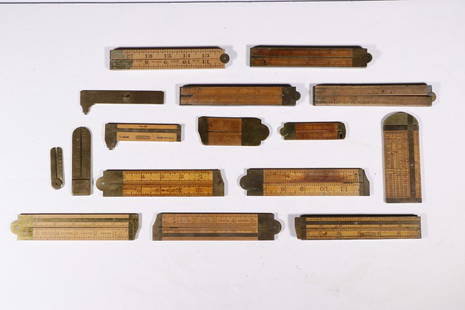
Sold2016LOT (17) ASSORTED VINTAGE BOXWOOD FOLDING RULESLOT (17) ASSORTED VINTAGE BOXWOOD FOLDING RULES INCLUDING STANLEY, 19/20TH CENTURYSee Sold Price
Sold2019LOT INCLUDING ASSORTED ADVERTISING, POCKET KNIVES,LOT INCLUDING ASSORTED ADVERTISING, POCKET KNIVES, FOREIGN CURRENCY, FOLDING RULERS, BEER TAP, ETCSee Sold Price
Sold2021(16) ASSORTED FOLDING MEASURESCollection of (16) Early Folding Rulers & Brass Measuring Items, most wood and brass, by assorted makers, incl: (9) Caliper rulers; (4) Folding rulers; (2) Brass harp string gauges; (1) Early rope meaSee Sold Price
Sold2020GROUP OF SEVENTEEN TRADITIONAL CHINESE PLATE STANDOf folding hinged style. Assorted wood types. Hight of largest 33 cm (13in)See Sold Price
Sold202117 Assorted Pocket Kn-ves17 assorted pocket kn-ves with wood, metal, plastic and horn handles, single and multi blades, by Oliver Winchester, Imperial, Camillus, Kutmaster, Klein Tools, Forest Master, brass knuckle type, etc.See Sold Price
Sold2023Group of 20+ Assorted Advertising ItemsIncludes Illinois Central Railroad pencils, Mack Firetruck bulldog pin, Garland Stoves folding ruler, and more, Largest measures 7 inches long.See Sold Price
Sold2021MEASURING TOOL LOTFOLDING RULERS AND TAPE MEASURES DISCLAIMER: Pick up DATE: Saturday, July 17 from 10am to 2pm at the address of 161 Raritan River Rd, Califon, NJSee Sold Price
Sold2015ASSORTED KOSMOS-TYPE BRASS NO. 1 SLIP BURNERS, LOT OFASSORTED KOSMOS-TYPE BRASS NO. 1 SLIP BURNERS, LOT OF 26, each with a shade ring, including 17 P&A Victor examples. Fourth quarter 19th/early 20th century. Provenance: The collection of Frank and KareSee Sold Price
Sold2024Folding park type bench in old red and green paintFolding wood park type bench in old red and green paint, 34" x 42" x 17", 17" seat heightSee Sold Price
Sold2018Morden: Antique Map of Shropshire, 1772Shropshire: 'SHROP SHIRE' by ROBERT MORDEN from Camden's Britannia, 1772 map Date: 1772 IMAGE SIZE: Approx 38.5 x 45.0cm, 15.25 x 17.75 inches (Large); Please note that this is a folding map. TYPE: DoSee Sold Price
Sold2018WORCESTERSHIRE: by ROBERT MORDEN from Camden'sDATE PRINTED: 1772 IMAGE SIZE: Approx 40.0 x 45.5cm, 15.75 x 17.75 inches (Large); Please note that this is a folding map. TYPE: Double page folio copperplate engraved map CONDITION: Good; suitable foSee Sold Price
Sold2018Scotland. North sheet. Highlands and Islands. SIDNEYTITLE/CONTENT OF MAP: 'Scotland [inset: Orkney Isles] [North sheet]' DATE: c1845 IMAGE SIZE: Approx 43.0 x 57.5cm, 17 x 22.75 inches (Large); Please note that this is a folding map. TYPE: Antique atlaSee Sold Price
Sold2023Asia. Arabia Siam China Anam Persia Abou Thubbi (Abu Dhabi) BARTHOLOMEW 1862 mapTITLE OF PRINT (NOT PRINTED ON THE PAGE):'Asia' DATE PRINTED: 1862 IMAGE SIZE: Approx 44.0 x 57.5cm, 17.25 x 22.75 inches (Large); Please note that this is a folding map. TYPE: Antique coloured atlasSee Sold Price
Sold2024Africa. Tribes/pre-European Kingdoms. Great Lakes & Nile. BARTHOLOMEW 1862 mapTITLE OF PRINT (NOT PRINTED ON THE PAGE):'Africa' DATE PRINTED: 1862 IMAGE SIZE: Approx 56.5 x 44.0cm, 22.25 x 17.25 inches (Large); Please note that this is a folding map. TYPE: Antique coloured atlaSee Sold Price
Sold2023COLONIAL AFRICA. Kamerun borders reflect 1911 Treaty of Fez. JOHNSTON 1912 mapCAPTION PRINTED BELOW PICTURE: 'Africa' DATE PRINTED: 1912 IMAGE SIZE: Approx 35.5 x 44.0cm, 14 x 17.25 inches (Large); Please note that this is a folding map. TYPE: Antique colour atlas map; Scale 1:See Sold Price
Sold2024COLONIAL AFRICA. Kamerun borders reflect 1911 Treaty of Fez. JOHNSTON 1913 mapCAPTION PRINTED BELOW PICTURE: 'Africa' DATE PRINTED: 1913 IMAGE SIZE: Approx 35.5 x 44.0cm, 14 x 17.25 inches (Large); Please note that this is a folding map. TYPE: Antique colour atlas map; Scale 1:See Sold Price
Sold2024CHINA & JAPAN showing Opium Wars battlefields & dates. JOHNSTON 1913 old mapCAPTION PRINTED BELOW PICTURE: 'China and Japan // Islands of Japan' DATE PRINTED: 1913 IMAGE SIZE: Approx 34.5 x 43.5cm, 13.5 x 17.25 inches (Large); Please note that this is a folding map. TYPE: AntSee Sold Price
Sold2023Carte de L'Afrique. Map of Africa. Takrur Guinea Congo. MALTE-BRUN c1871TITLE/CONTENT OF MAP: 'Carte de l'Afrique [Map of Africa]' DATE PRINTED: c1871 IMAGE SIZE: Approx 35.0 x 45.0cm, 13.75 x 17.75 inches (Large); Please note that this is a folding map. TYPE: Antique 19tSee Sold Price
Sold2023Africa. Tribes/pre-European Kingdoms. Piaggia's Great Lake. BARTHOLOMEW 1870 mapTITLE OF MAP (NOT PRINTED ON THE PAGE):'Africa' DATE PRINTED: 1870 IMAGE SIZE: Approx 57.5 x 45.0cm, 22.75 x 17.75 inches (Large); Please note that this is a folding map. TYPE: Antique atlas map CONDISee Sold Price
Sold2024Colonial Africa. Ethnicity. British French Portuguese Belgian. TIMES 1922 mapTITLE/CONTENT OF MAP: 'Africa - Political' DATE PRINTED: 1922 IMAGE SIZE: Approx 44.0 x 57.5cm, 17.25 x 22.5 inches (Large); Please note that this is a folding map. TYPE: Antique atlas map CONDITION:See Sold Price
Sold2024The Island of Cuba & the Cayman Islands. LOWRY 1860 old antique map plan chartCAPTION PRINTED BELOW PICTURE: 'The Island of Cuba' DATE PRINTED: 1860 IMAGE SIZE: Approx 36.5 x 17.5cm, 14.5 x 6.75 inches (Large); Please note that this is a folding map. TYPE: Antique engraved atlaSee Sold Price
Featured2 days LeftJasper52EUROPE. Political. Austro-Hungarian Monarchy. Shipping routes. JOHNSTON 1906 map$20
Featured2 days LeftJasper52SOUTHERN EUROPE & MEDITERRANEAN. inset Gibraltar & Malta. BARTHOLOMEW 1898 map$20
2 days LeftJasper52Svezia, Novergia, e Danimarca'. Scandinavia antique map by Claudio Buffier 1788$40
Featured2 days LeftJasper52Johnson's Europe. Navigators' routes. Continental Shelf 1861 old antique map$65
2 days LeftJasper52Central Europe roads canals railways Germany, Holland & Belgium. HUGHES 1862 map$25
2 days LeftJasper52Central Europe roads canals railways Germany, Holland & Belgium. HUGHES 1856 map$25
2 days LeftJasper52SCANDINAVIA.Shows early railways inc Oslo-Eidsvoll.Norway Sweden.LOWRY 1863 map$25
2 days LeftJasper52Turchia d'Europa… Turkey in Europe. Balkans Greece Bulgaria &c. ZATTA 1783 map$55
2 days LeftJasper52Gli Stati del Piemonte e Savoja. Savoie. French & Italian Alps. ZATTA 1784 map$130


![Scotland. North sheet. Highlands and Islands. SIDNEY: TITLE/CONTENT OF MAP: 'Scotland [inset: Orkney Isles] [North sheet]' DATE: c1845 IMAGE SIZE: Approx 43.0 x 57.5cm, 17 x 22.75 inches (Large); Please note that this is a folding map. TYPE: Antique atla](https://p1.liveauctioneers.com/5584/122263/62235321_1_x.jpg?height=310&quality=70&version=1527034376)


![Carte de L'Afrique. Map of Africa. Takrur Guinea Congo. MALTE-BRUN c1871: TITLE/CONTENT OF MAP: 'Carte de l'Afrique [Map of Africa]' DATE PRINTED: c1871 IMAGE SIZE: Approx 35.0 x 45.0cm, 13.75 x 17.75 inches (Large); Please note that this is a folding map. TYPE: Antique 19t](https://p1.liveauctioneers.com/5584/308981/165185437_1_x.jpg?height=310&quality=70&version=1699996168)


