Sold20231842 MATHER & SMITH WALL MAP OF LONG ISLAND, NYHand-colored lithograph. "A Geological Map of Long & Staten Islands with the Environs of New York"; William W. Mather, geologist and J. Calvin Smith, surveyor. This landmark pre-Civil War map is the eSee Sold Price
Sold2023Sketch of the Country...Long Island.[Map/New York] Sketch of the Country Illustrating the Late Engagement in Long Island, from The Gentleman's Magazine, London, 1776. Handcolored copperplate engraving. Published in October 1776, of thisSee Sold Price
Sold2021(NEW YORK--LONG ISLAND.) F.W. Beers. Atlas of Long(NEW YORK--LONG ISLAND.) F.W. Beers. Atlas of Long Island, New York. Profusion of hand-colored lithographed mapsheets, several folding (complete). Folio, 16x13 inches, publisher's morocco backed gilt-See Sold Price
Sold2023Beers Comstock & Cline. - Atlas of Long Island, New YorkLot 52 Beers Comstock & Cline. American PublisherAtlas of Long Island, New York (1873) lithography with hand coloring profusion of hand-colored lithographed mapsheets, several folding, publisher's moSee Sold Price
Sold2022Six Atlas of New York and Vicinity, hand colored engraved maps including Sommers, Patterson,Six Atlas of New York and Vicinity, hand colored engraved maps including Sommers, Patterson, Wakefield, Ossining, City Island, and North Salem, 16 3/4" x 13 3/4". Provenance: Originally from Credit SuSee Sold Price
Sold20181796 State of Rhode Island Hand Colored MapNew York,Dated 1796 Map of the State of Rhode Island as updated by the latest surveys,1796, hand colored on laid paper, engraved for the American edition of Winterbothams America, published by John ReSee Sold Price
Sold2023E. Belcher Hyde Map Co. - Maps of Suffolk, Group of 4Lot 49 E. Belcher Hyde Map Co. American Manufacturer (fl. c. 1880 - 1920) Maps of Suffolk, Group of 4 (1916) lithograph with hand coloring from Suffolk County 1916 Vol 2 Long Island, New York, includeSee Sold Price
Sold2018Currier & Ives Hand Colored Print of Ocean ExpressCirca 1860. Sketched by J. Smith and Son Brooklyn Long Island engraved by C. Pearson and published by Currier and Ives 152 Nassau Street New York. The piece having a small abrasion to paper in the skySee Sold Price
Sold2023E. Belcher Hyde Map Co. - Maps of Sag Harbor, Group of 2Lot 48 E. Belcher Hyde Map Co. American Manufacturer (fl. c. 1880 - 1920) Maps of Sag Harbor, Group of 2 (1916) lithograph with hand coloring from Suffolk County 1916 Vol 2 Long Island, New York 17 xSee Sold Price
Sold2023An 1860 Map, Counties of New York, New Hampshire, Etc...Hand colored lithograph, by Samuel Augustus Mitchell (1790-1868). :County Map of the States of New York, New Hampshire, Vermont, Massachusetts, Rhode Island and Connecticut". Dimensions:15 1/2" x 23 1See Sold Price
Sold2017GREATEST NEW YORK HAND COLORED MAPOffset print. Dimensions: (Frame) H 15.5" x W 33.5", (Sight) H 8.5" x W 26.75" Condition: No issues to note.See Sold Price
Sold20201858 Framed Map of North AmericaTitle: 1858 Framed Map of North America Medium: Ink on Paper/Glass/Wood Dimensions: 18.5"X21" Map of North America dated 1858. Engraved and published by J.H. Colton in New York. Hand colored. Map holdSee Sold Price
Sold20241866 FRAMED MAP OF PRUSSIA GERMANYJOHNSON'S NEW YORK, HAND COLORED MAP, DATED 1866. LOOSE IN FRAME. 26" X 32" IN FRAMESee Sold Price
Sold2018Tanner: Antique Map of Missouri, 1843Title/Content of Map: Missouri by Tanner Date Printed: 1843 Cartographer: based on the work of H.C. Tanner Size: 17" x 14" Material/Medium: Paper Provenance: New York Hand colored engraved Map. From tSee Sold Price
Sold2018Tanner: Antique Map of Arkansas, 1843Title/Content of Map: Arkansas by Tanner Date Printed: 1843 Cartographer: based on the work of H.C. Tanner Size: 17" x 14" Material/Medium: Paper Provenance: New York Hand colored engraved Map. From tSee Sold Price
Sold2018Tanner: Antique Map of Connecticut, 1843Title/Content of Map: Connecticut by Tanner Date Printed: 1843 Cartographer: based on the work of H.C. Tanner Size: 17" x 14" Material/Medium: Paper Provenance: New York Hand colored engraved Map. FroSee Sold Price
2018Tanner: Antique Map of Argentina & Chile, 1843Title/Content of Map: Argentina & Chile by Tanner Date Printed: 1843 Cartographer: based on the work of H.C. Tanner Size: 17" x 14" Material/Medium: Paper Provenance: New York Hand colored engraved MaSee Sold Price
Sold2018Prussia by TannerTitle/Content of Map: Prussia by Tanner Date: 1843 Cartographer: based on the work of H.C.Tanner Material/Medium: Paper Size: 17" x 14" Provenance: New York Hand colored engraved map. Based on the worSee Sold Price
Sold2018Kansas & Nebraska by ColtonTitle/Content of Map: Kansas & Nebraska by Colton Date: 1859 Cartographer: H. J. Colton Material/Medium: Paper Size: 17 1/2" x 15" Provenance: New York Hand colored engraved Map. Piblished in New YorkSee Sold Price
Sold2018Western Hemisphere by Reinecke *RARE*Title/Content of Map: Western Hemisphere by Reinecke *RARE* Date: 1804 Cartographer: J.C. M. Reinecke Material/Medium: Paper Size: 27" x 23" Provenance: New York Rare hand colored engraved Map. PleaseSee Sold Price
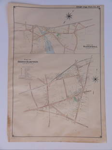
Sold2016Bridgehampton & Watermill, Long Island, 1902Original engraving published by E. Belcher Hyde from "Atlas of Suffolk County, Long Island, New York," Philadelphia, 1902. Map features family names, historic buildings and railroad routes. DimensionsSee Sold Price
Sold2016A Map of the United States & MexicoHenry Tanner (1786-1858). New York: Tanner, 1850. Hand-colored Pocket Map. 23 x 29 inches visible, 38 x 39 1/2 inches framed.See Sold Price
Sold2018Map of the Basin of the St. Lawrence.[Map] Keefer, Thomas C. Map of the Basin of the St. Lawrence. New York: Ackerman Litho., 1853. Hand-colored map depicting the Great Lakes Region for Isreal de Wolf Andrew’s report for the TreasuSee Sold Price
Sold2023JOHN EDWARD COSTIGAN (Rhode Island/New York, 1888-1972), "Woman and Goat"., Hand-colored engraving,JOHN EDWARD COSTIGANRhode Island/New York, 1888-1972"Woman and Goat". Signed and titled in pencil lower margin.Hand-colored engraving, 10" x 12". Framed 20.5" x 22".See Sold Price
2 days LeftTremont AuctionsJohn Speed and Francis Lamb "Map of New England and New York", ca. 1676. Hand colored engraved map$900(3 bids)
May 21Hess Fine AuctionsBakelite Art Deco Seth Thomas 8 Days Star Pedestal Desk Mantel Clock MHP Collection$30(2 bids)
6 days LeftRobinhood AuctionsCharles Fazzino, "There's Music: New Jersey, New York, Long Island Too!! (Sky Blue)" Framed 3D$1,000
2 days LeftRobinhood AuctionsCharles Fazzino, "There's Music: New Jersey, New York, Long Island Too!!" Framed 3D Limited Edition$1,000
1 day LeftSeized Assets AuctioneersThere's Music: New Jersey, New York, Long Island Too!! by Fazzino, Charles$1
2 days LeftSeized Assets AuctioneersThere's Music: New Jersey, New York, Long Island Too!! by Fazzino, Charles$1
2 days LeftSeized Assets AuctioneersThere's Music: New Jersey, New York, Long Island Too!! by Fazzino, Charles$1
May 14Fleischer's Auctions1755 Map Partie de l'Amerique Septentrionale, qui comprend Le Cours de L'Ohio...$200(3 bids)
May 12Robinhood AuctionsCharles Fazzino- 3D Construction Silkscreen Serigraph "There's Music: New Jersey, New York, Long$1,100


![Sketch of the Country...Long Island.: [Map/New York] Sketch of the Country Illustrating the Late Engagement in Long Island, from The Gentleman's Magazine, London, 1776. Handcolored copperplate engraving. Published in October 1776, of this](https://p1.liveauctioneers.com/179/305680/163721131_1_x.jpg?height=310&quality=70&version=1697214016)


![Map of the Basin of the St. Lawrence.: [Map] Keefer, Thomas C. Map of the Basin of the St. Lawrence. New York: Ackerman Litho., 1853. Hand-colored map depicting the Great Lakes Region for Isreal de Wolf Andrew’s report for the Treasu](https://p1.liveauctioneers.com/928/124137/63148817_1_x.jpg?height=310&quality=70&version=1530051387)


