Sold2018Blaeu Map of Europe -- Europa Recens DescriptaTitle/Content of Map: Blaeu Map of Europe -- Europa Recens Descripta Date: 1635, Amsterdam Cartographer: W Blaeau Size: 16.1 X 21.9 in. This is a grand, large, classic map of Europe, produced at the gSee Sold Price
Sold20231743 Homann Map of Europe -- Europa Secundum Legitimas Projectionis Stereographicae Regulas et JuxtaTitle: 1743 Homann Map of Europe -- Europa Secundum Legitimas Projectionis Stereographicae Regulas et Juxta Recentissimas Observationes Aeque ac Relationes… Cartographer: J. Homann Year / Place: 174See Sold Price
Sold20211598 Munster / Petri Map of Europe -- Europa das einTitle: 1598 Munster / Petri Map of Europe -- Europa das ein Drittheil der Erden nach gelegenheit unserer zeit beschrieben Cartographer: Munster / Petri Year/Place: 1598 c., Basel Map Dimensions (in.):See Sold Price
Sold2021Antique Framed Map of Europe, Europa Guilielmo BlaeuwAntique Color Map of Europe, Dutch Cartography. "Europa Recens Descripta" by Guilielmo Blaeuw, a cartographer for the Dutch East India Company. Lots of colorful detail of different nationalitiSee Sold Price
Sold2017Homann: Map of Europe, 1743Map: 1743 Homann Map of Europe -- Europa Secundum Legitimas Projectionis Stereographicae Regulas et Juxta Recentissimas Observationes Aeque ac Relationes… Cartographer: J. Homann Year / Place: 1743See Sold Price
Sold2024L'Europa. Europe. DE ROSSI 1677 old antique vintage map plan chartTITLE/CONTENT OF MAP: L'Europa [Europe] DATE PRINTED: 1677 IMAGE SIZE: Approx 44.0 x 56.5cm, 17.25 x 22.25 inches (Large) TYPE: Antique 17th century folio atlas map CONDITION: Good; suitable for framiSee Sold Price
Sold2020[SEUTTER, M] 52 Maps of Europe sold togetherSEUTTER,M. 52 Maps of Europe sold together. ca. 1700. Includes. Europa ** Flandria ** Hanoniae ** Belgii **Luxemburg ** Dauphine Five Delpinatus ** Parmensis Et Placentinus ** Transylvaniae ** DucatusSee Sold Price
Sold2017Homann: Antique Map of SouthEast Europe, 1753Title/Content of Map: 1753 Homann Map os the Danube and SouthEast Europe -- Fluviorum in Europa principis Danubii cum adiacentibus Regnis nec non totius Graeciae et Archipelagi Novissima Tabula Date PSee Sold Price
Sold2021Antique Map ETHNOGRAPHISCHE KARTE VON EUROPA, J. MeyerAntique Map ETHNOGRAPHISCHE KARTE VON EUROPA (German)(Translated: Ethnographic Map of Europe), Joseph Meyer (1796-1856) | Map shows the various races/peoples as they are spread throughout Europe. ThisSee Sold Price
Sold2017Map of Europe, 1879 by Justus Perthes, Gotha, GermanyEuropa In the scale of 1.15.000.000. Published. 1879. Gotha. Germany By A. Petermann. Justus Perthes, Adolf Stieler. Handatlas uber alle Theile der Erde und uber das Weltgebaude. Adolf Stieler, GothaSee Sold Price
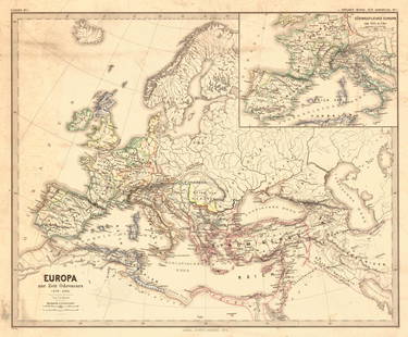
Sold2018Menke: Antique Map of Europe at time of OdovacarsTitle/Content of Map: Europa Zur Zeit Odovacars (476-493.) Date Printed: 1874 Cartographer: MENKE, TH. Publisher: JUSTUS PERTHES 1874 GOTHA Size: Quarto – 12.80 H x 15.75 W Inches "Von Th. Menke..."See Sold Price
Sold2023Map of Europe 1619 – 1672 with towns and costumesDescription: Map of Europe 1619 – 1672 with towns and costumes / EUROPA RECENS DEFERIPTA.Measurement approximate:Material: PaperSee Sold Price
Sold2023"Europa das ein Drittheil der Erden nach Gelegenheit unsern Zeiten", Sebastian Munster, ca. 1569"Europa das ein Drittheil der Erden nach Gelegenheit unsern Zeiten". (First Map of the Continent of Europe). Basle, ca. 1569. Sebastian Munster (German 1488-1552), was a cartographer, cosmographer, anSee Sold Price
Sold2022L'Europa divisa ne'suoi principali stati. Europe. ZATTA 1779 old antique mapTITLE/CONTENT OF MAP: 'L'Europa divisa ne'suoi principali stati' Europe divided into its main states DATE PRINTED: Published in 1779. Engraved in 1777 (this date is printed on the map). IMAGE SIZE: ApSee Sold Price
Sold2023Map of the Turkish Empire in Europe by J. Walch - 1812 engravingMap of the Turkish Empire in Europe. Title: Karte von dem Türkischen Reiche in Europa Engraver and cartographer: Johannes Walch (25 November, 1757 - 23 March, 1815). Description: handcolored engrSee Sold Price
Sold2017Ptolemy: Map of Bactria Scythia North India, 1597Map: Tabula Asiae VIII Cartographer: Ptolemy, Magini / Porro, P.Keschedt Place & Date: Cologne / 1597 Size: 6 3/4" x 5 1/4" Condition: b&w; overall age toning The eighth Ptolemaic Asia map from the MaSee Sold Price
Sold2018Ptolemy/Magini: Antique Map of France, Germany, 1598Map: Tavola della Gallia, Terza dell'Europa Tavola della Gran Germania, Quarta dell'Europa Cartographer: Magini / Porro / Galignani Fratelli Place & Date: Venice / 1598 Size: 6 5/8" x 5 1/8" (maps); 7See Sold Price
Sold2017Ptolemy: Antique Map of Ancient Caucasus Region, 1597Map: Tabula Asiae II Cartographer: Ptolemy, Magini / Porro, P.Keschedt Place & Date: Cologne / 1597 Size: 6 3/4" x 5 1/4" Condition: b&w; overall age toning and a spot in the upper right quadrant TheSee Sold Price
Sold2017Antique Ptolemaic Map of Pakistan/Indus River, 1597Map: Tabula Asiae IX Cartographer: Ptolemy, Magini / Porro, P.Keschedt Place & Date: Cologne / 1597 Size: 6 3/4" x 5 1/4" Condition: b&w; overall age toning, some browning along the centerfold The ninSee Sold Price
Sold2023[MAP] SEUTTER, M. EUROPA RELIGIONIS CHRISTIANAESeutter, Matthaus. EUROPA RELIGIONIS CHRISTIANAE MORUM ET PACIS AC BELLI ARTIUM CULTU Omnium Terrarum Orbis Partium Praestantiss... [EUROPE OF THE CHRISTIAN RELIGION OF MANNERS AND OF PEACE AND THE ARSee Sold Price
Sold2020AN ANTIQUE MAP, "Europe (Evrop)," JOHN SPEED,AN ANTIQUE MAP, "Europe (Evrop)," JOHN SPEED, CARTOGRAPHER, 1626-1676, hand-colored engraving on paper, Abraham Goos (1589-1643), engraver, published for merchants Thomas Basset and Richard Chiswell iSee Sold Price
Sold20231850s Dufour ATLAS 42 HUGE MAPS Europe ENORMOUS & RARE Geography Cartography1850s Dufour ATLAS 42 HUGE MAPS Europe ENORMOUS & RARE Geography Cartography Adolphe Dufour was a 19th-century French cartographer and map maker known for his highly detailed maps of European cities aSee Sold Price
Sold20212) STIELER & MITCHELL MAPS EUROPE, TURKEY & GREECE(lot of 2) Framed maps, including: (1) engraving with hand coloring on paper, German map of Europe, Turkey, Greece, and the Ionian Islands, from "Stielers Schul-Atlas," published by Justus Perthes, GoSee Sold Price
Sold20221596 Magini Map of Sicily and Sardinia -- Sardinia etTitle: 1596 Magini Map of Sicily and Sardinia -- Sardinia et Sicilia Cartographer: G Magini Year / Place: 1596 c., Venice Map Dimension (in.): 5.1 X 6.8 in. This is a fine map of the two large ItalianSee Sold Price
Featured1 day LeftJasper52Europe's Overland & Sea Communications with Asia. Chart. LARGE 1959 old map$35
4 days LeftTrillium Antique Prints & Rare BooksDe Jode, Rare, pub. 1593 - Map of Europe (Nova Totius Europae Tabula)$160(4 bids)
2 days LeftSloans & KenyonTHE TRANS SIBERIAN EXPRESS TRAVEL POSTER, 1930, - Sight: 39 x 27 inches.$2,100(2 bids)
4 days LeftTrillium Antique Prints & Rare BooksPtolemy & Magini, pub. 1620 - 4 Maps of European Countries: Spain, Portugal, France, & Greece$50
4 days LeftTrillium Antique Prints & Rare BooksPtolemy & Magini, pub. 1620 - 3 Maps of Italy: Rome, Naples, Lombardia$55(2 bids)
9 hrs LeftJasper521783 Bellin Map Tracing Explorers Marco Polo and Jenkinson and Showing Asia and Europe -- Carte pour$95


![L'Europa. Europe. DE ROSSI 1677 old antique vintage map plan chart: TITLE/CONTENT OF MAP: L'Europa [Europe] DATE PRINTED: 1677 IMAGE SIZE: Approx 44.0 x 56.5cm, 17.25 x 22.25 inches (Large) TYPE: Antique 17th century folio atlas map CONDITION: Good; suitable for frami](https://p1.liveauctioneers.com/5584/322790/173578184_1_x.jpg?height=310&quality=70&version=1710881198)
![[SEUTTER, M] 52 Maps of Europe sold together: SEUTTER,M. 52 Maps of Europe sold together. ca. 1700. Includes. Europa ** Flandria ** Hanoniae ** Belgii **Luxemburg ** Dauphine Five Delpinatus ** Parmensis Et Placentinus ** Transylvaniae ** Ducatus](https://p1.liveauctioneers.com/1124/187577/94368891_1_x.jpg?height=310&quality=70&version=1607095126)


![[MAP] SEUTTER, M. EUROPA RELIGIONIS CHRISTIANAE: Seutter, Matthaus. EUROPA RELIGIONIS CHRISTIANAE MORUM ET PACIS AC BELLI ARTIUM CULTU Omnium Terrarum Orbis Partium Praestantiss... [EUROPE OF THE CHRISTIAN RELIGION OF MANNERS AND OF PEACE AND THE AR](https://p1.liveauctioneers.com/8124/310027/165853626_1_x.jpg?height=310&quality=70&version=1700184289)


