Sold202215+ Highway Maps Gulf, Sohio, D-X, Texaco otherSinclair, Standard Oil, hotel booklets, Shell Lubricant Sleeve, various degrees of wearSee Sold Price
Sold2018Large Lot of Gas Station Maps- Texaco, DX, Sohio +Over 45 maps included. As pictured, various stations and states.See Sold Price
Sold2017Bellin: Antique Map of Gulf of St Lawrence, 1750Map: Gulf of St Lawrence Date Printed: 1750-60's Cartographer: Jacques Nicholas Bellin Material/Medium: Paper Size: 15 1/2" x 10" Copperplate engraved. Double page map. From the Atlas De L'Histoire GeSee Sold Price
Sold2017Bellin: Antique Map of Gulf of Mexico / Caribbean, 1757Map: Carte du Golphe de Mexique et des Isles de l'Amerique Cartographer: Jacques Bellin Place & Date: Paris / 1757 Size: 15" x 10 3/4" Condition: outline color; washed; some nicks and splits in edgesSee Sold Price
Sold20201778 Handcolored Map West Indies Gulf of Mexico1778 "The West Indies and Gulf of Mexico from the Latest and Best Observations", by John Lodge. Hand colored map. Fine, measures 15 x 9". Reserve: $80.00 Shipping: Domestic: Flat-rate of $5.00 to anywSee Sold Price
Sold2019Carte du Golfe du Mexique et des Isles de l'Amerique'TITLE/CONTENT OF MAP: 'Carte du Golfe du Mexique et des Isles de l'Amerique [Map of the Gulf of Mexico and the Caribbean islands]' DATE PRINTED: 1754 IMAGE SIZE: Approx 28.5 x 39.0cm, 11.25 x 15.5 incSee Sold Price
Sold2018Rare 1921 auto road atlas. 11.7 x 15Reserve Reduced! This rare and unusual early auto road atlas was published during the time the National Highway System was being developed. It includes individual “auto-trails” maps for each stateSee Sold Price
Sold2018Bellin/Arkstee & Merkus: West Indies & Gulf of MexicoMap: Karte von dem Mexicanischen Meerbusen und dem Inseln von America Cartograper: Jacques Bellin / Arkstee & Merkus Place / Date: Leipzig / 1760 Size: 15" x 10 3/4" Condition: b&w. overall age toningSee Sold Price
Sold2019Eight (8) Augustus Mitchell MapsCollection of eight maps including New Jersey/Maryland Delaware 1872, Two north and South Carolina 1872 maps (15" x 12"), Minnesota 1890 , Florida and the Carolinas 1860, County map of the state of ArSee Sold Price
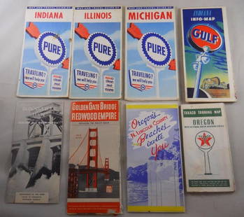
Sold2018Grouping of vintage gas station road maps and travelPure, Gulf, Texaco Maps. Golden Gate Bridge, N. Lincoln, Bonneville Dam – 8 pcs. Total.See Sold Price
Sold2016Metellus (Johannes) - Regnum Monomotapae,early map of Southern Africa and Madagascar, strapwork title cartouche below, from Botero's Theatrum Principum Orbis Universi, engraved map, 15 x 230mm., Latin text verso, full margins, central verticSee Sold Price
Sold2018Map of St. DomingueTitle: Map of St. Domingue (Hispaniola) Artist: A. Tardieu Medium: ink on paper Dimensions: 20" X 15" Map of the Island of St. Domingue dated 1802. Engraved and drawn by Ambroise Tardieu in Paris.ExtrSee Sold Price
Sold20222 SEASIDE ADVERTISMENTSSST MOTOR OIL RACK SIGN & PAPER MAP OF CALIFORNIA. SURFACE SCRATCHES, FOLDED CORNERS ON MAP. 15" x 16"See Sold Price
Sold2020COLORED MAP OF POITIERS, FRANCE16th/17th Century Abraham Ortelius Condition: with repairs, creasing, and discoloration throughout map: 15 x 20 inches; frame: 20 x 24 3/4 inchesSee Sold Price
Sold2021William and Johannes Blaeu, 'Flandriae Teutonicae ParsWilliam and Johannes Blaeu, 'Flandriae Teutonicae Pars Orientalior', a hand-coloured 17th Century map, 15" x 19.5", (unframed).See Sold Price
Sold2022Willem Blaeu, 'Fossa Sanctae Mariae, quae et Eugeniana Dicitur vulgo de Nieuwe Grift', aWillem Blaeu, 'Fossa Sanctae Mariae, quae et Eugeniana Dicitur vulgo de Nieuwe Grift', a hand-coloured 17th Century map, 15" x 20", (unframed).See Sold Price
Sold2022John SPEED: Two Antique Maps of IrelandTwo framed antique maps of Ireland by John Speed, a well known English cartographers circa 17th century. [Maps: 15" H x 20" W; Frames: 24" H x 28 1/2" W].See Sold Price
Sold20211610 Map of County of Radnor (Wales)Unknown cartographer. Hondius is featured, described by Christopher Saxon, and published by John Speed. Conservation framed. MEASUREMENTS: Map 15" high x 20" wide; overall with frame 22-3/4" high x 27See Sold Price
Sold2021Jansson 1645 Map of Sweden (Gothia)Map of southern Sweden depicting forests and lakes, with strap work title cartouche includes scales. Conservation framed. MEASUREMENTS: Map 15" high x 19" wide; overall with frame 25" high x 29" wide.See Sold Price
Sold20201950’s era Mobil dealer map display rack, 24 x 15.1950’s era Mobil dealer map display rack, wall hanging, with period maps, 24 x 15.5See Sold Price
Sold2023Group of Five MapsGroup of Five Maps, to include a new map of ancient Greece Thrace by William; Sweden; East Nottingham; Ireland; along with South Eastern Greece Attica Megorica Corinthiaca engraved map; largest 15" xSee Sold Price
Sold2021Alexander Drummond's TravelsLondon, 1754.Includes plates and maps. Size: 15 x 10 x 2 in. Please note that all sales are final. No refunds will be given under any circumstances.See Sold Price
Sold2021Gulf Motor Oil and Dance CansGulf Motor Oil and Dance Cans. This item requires third party shipping or pickup arrangements to be made. Dimensions of Gulf: 12 x 15 x 12See Sold Price
Jun 22Check the Oil Promotions, LLCTexaco Touring Service Advertising Map Rack Display with 15 Maps$25(1 bid)
21 hrs LeftJasper52Plan du Portendic, appellé aussi…' Portendick Mauritania BELLIN/SCHLEY 1747 map$15
21 hrs LeftJasper52Coste Occidentale d’Afrique…' Arguin Bay Cap Blanc Mauritania. BELLIN 1746 map$30
21 hrs LeftJasper52Coste Occidentale d’Afrique'. Bay of Arguin, Mauritania. BELLIN/SCHLEY 1747 map$30
Jun 22Check the Oil Promotions, LLCTexaco Fire Chief Localized For You Gas Pump Topper Sign$25(1 bid)
21 hrs LeftJasper52Carte de la Haute et de la Basse Guinée. Gulf of Guinea Africa. BONNE 1780 map$40
21 hrs LeftJasper52Carte du Golfe de Guinée. Gulf of Guinea Nigeria Cameroon BELLIN/SCHLEY 1748 map$45
21 hrs LeftJasper52Carte du Golfe de Guinée'. Gulf of Guinea. Nigeria & Cameroon. BELLIN 1747 map$45


![Carte du Golfe du Mexique et des Isles de l'Amerique': TITLE/CONTENT OF MAP: 'Carte du Golfe du Mexique et des Isles de l'Amerique [Map of the Gulf of Mexico and the Caribbean islands]' DATE PRINTED: 1754 IMAGE SIZE: Approx 28.5 x 39.0cm, 11.25 x 15.5 inc](https://p1.liveauctioneers.com/5584/144578/73088245_1_x.jpg?height=310&quality=70&version=1561513819)


![John SPEED: Two Antique Maps of Ireland: Two framed antique maps of Ireland by John Speed, a well known English cartographers circa 17th century. [Maps: 15" H x 20" W; Frames: 24" H x 28 1/2" W].](https://p1.liveauctioneers.com/1221/264089/138965458_1_x.jpg?height=310&quality=70&version=1667576821)


