Sold2019"Provincia di Kent". Kent county map. ZATTA 1779 oldTITLE/CONTENT OF MAP: 'Provincia di Kent di nuova projezione' The county of Kent The top image on the right hand side shows the entire map. To view a close up of the map showing the level of printed dSee Sold Price
Sold2019Group of Three Maps by Antonio Zatta (1757-1797,Group of Three Maps by Antonio Zatta (1757-1797, Venice), consisting of "Essex/Middlesex," 1779; "Surrey/Kent," 1779; and "L'Estremadura di Portogallo Alentejo ed Algarue," 1775; Algarue- H. - 14 in.,See Sold Price
Sold2023Emisfero Terrestre Meridionale… Southern hemisphere. ZATTA 1779 old mapTITLE/CONTENT OF MAP: 'Emisfero Terrestre Meridionale tagliato sul' Equatore' "The southern hemisphere", showing the voyages of Cook and Bougainville between 1766-1771. The coastlines of Australia andSee Sold Price
Sold2022L'Europa divisa ne'suoi principali stati. Europe. ZATTA 1779 old antique mapTITLE/CONTENT OF MAP: 'L'Europa divisa ne'suoi principali stati' Europe divided into its main states DATE PRINTED: Published in 1779. Engraved in 1777 (this date is printed on the map). IMAGE SIZE: ApSee Sold Price
Sold2022Il Padovano…. Padua province, Veneto, Italy. ZATTA 1784 old antique mapTITLE/CONTENT OF MAP: 'Il Padovano di Giovanni Valle Giustinopolitano di nuova projezione' "The province of Padua", Veneto, Italy DATE PRINTED: Published in 1784. Engraved in 1784 (this date is printeSee Sold Price
Sold2024Set of 7 James Kent Old Foley Dinner Plates10” Diameter. Set of seven James Kent “Old Foley” dinner plates with a pink design depicting a landscape scene across the entire top and a scalloped edge. Stamped along bottom “GenuineSee Sold Price
Sold2018Zatta: Antique Map of Northern Netherlands, 1778Title/Content of Map: 1778 Zatta Map of Northern Netherlands -- Le Provincie di Frisia, Groninga et Over-Yssel con parte dell' Ollanda Propria… Date Printed: 1778, Venezia Cartographer: A Zatta SizeSee Sold Price
Sold202260031: George Read autograph document signed ("Geo: ReaGeorge Read autograph document signed ("Geo: Read"). One page, 8.25" x 13", Kent County, Delaware; April 1771. Docketed. George Read&See Sold Price
Sold2020KENT ULLBERG: "OLD SALTS"patinated bronze inscribed in casting and numbered ap/20 Provenance: The Douglas & Eunice Goodan Living Trust 12 inches wide; 15 inches highSee Sold Price
Sold2016LeRoy Neiman (American, 1921-2012) Thomas A. BecLeRoy Neiman (American, 1921-2012)Thomas A. Becket Gym, Old Kent Road, London,See Sold Price
Sold2022Ammi Phillips, Portrait of a Seated WomanAmmi Phillips (American, 1788-1865), Kent period, circa 1845, oil on canvas depicting a seated, hazel-eyed woman in black with a fine lace collar and brooch, having original strainer, 27 1/2" x 32 1/4See Sold Price
Sold2016Britains Set #21 British Army Display1st Version. Circa 1900. 11th Hussars with short carbines, Lifeguards with tin swords, and Scots Guards and East Kent Regiment on round bases. In original Types of the British Army box. 29 Pieces. ConSee Sold Price
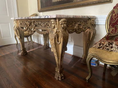
Sold2023SUPERB GILT WOOD AND ORIGINAL MARBLE TOP CENTER TABLE WILLIAM KENTSUPERB GILT WOOD CENTER TABLE POSSIBLY BY WILLIAM KENT. RETAINING ITS ORIGINAL MARBLE TOP. INCREDIBLE CARVING THOUGHOUT. CARVED IN THE ROUND. EXCEPTIONAL DETAIL IN THIS PIECE! FROM OLD SOUTHER ESTATE.See Sold Price
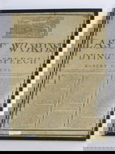
Sold2024The Last Words and Dying Speech of Robert Youngprinted broadside by the Printing Office Worcester. Young was executed on March 11, 1779 for the rape of the 11 year old child of Jane Green in Brookfield, Worcester County on September 3. At the topSee Sold Price
Sold2024Moule, Thomas C1835 Lot of 12 British County MapsSteel Engraved Map Published C1835, London for "A Complete and Universal English Dictionary" by the Rev. James Barclay et al. Maps by Thomas Moule. Paper Size: 10.5 x 8 inch (27 x 21cm) Faults presentSee Sold Price
Sold2024GIO PONTIDivano Legno di noce, tessuto imbottito. Provenienza per casa G. provincia di Torino, anni '30. Perizia Gio Ponti Archives cm 74x158x80 A SETTEE BY G. PONTI Buone condizioni generali. Righe, graffi, sSee Sold Price
Sold2022World.- Bordone (Benedetto di) [World Map], woodcut, [1522].World.- Bordone (Benedetto di) [World Map], early map showing the recent developments in cartography and departing from Ptolemaic models, including open water between the two continents and not joininSee Sold Price
Sold2017LARGE LOT OF OLD MAPSINCLUDES LANDMARK MAPMAKING BOOK. LARGE VARIETY OF MAPS.maps are old, some are taped to boards, very fragile, and/or torn/cracking. ***Additional photo links available at http://paceantiques.com/See Sold Price
Sold2016Enrico Castellani (Castelmassa 1930)pennafeltro nera su cartoncino, cm 47,8 x 33Firmato in basso a destra: Castellani 99 BIBLIOGRAFIA: Edizioni Internet, a cura di M. Zatta, ed. Artecom, Tolfa, 1999 ripr. p. 48Il disegno è stato eseguiSee Sold Price
Sold2024Willem Blaeu, Map of The AmericasAmsterdam, 1617. Together with "Early Maps" by Tony Campbell, Abbeville Press and "The United States in Old Maps and Prints, Eduard Van Ermen. 3 pieces Sight size: 16-1/2"h x 22"w Overall: 23-1/2"h xSee Sold Price
Sold2022(WEST--KANSAS.) Letters and map from early Nemaha County.(WEST--KANSAS.) Letters and map from early Nemaha County. Printed map, 27½ x 19½ inches; toning, partial separations at folds, other minor wear. with 11 related letters to the Sage family daSee Sold Price
Sold2022Tennessee Plantation Sugar Chest 1820-1830Middle Tennessee Plantation Cherry Sugar Chest 1820-1830. From an old Shelby county Tennessee family. A scarce tall form with turned Legs that extend down from the bottom of the case 17 1/2". The secoSee Sold Price
Sold2021FOUR-TIER GENERAL STORE CABINET.Wonderful old oak map cabinet sporting a older restoration that shows very nicely. These are getting more difficult to find, especially functional and with such a fantastic finish. Some very slight suSee Sold Price
Sold2022Midleton-30 year old-1969Midleton-30 year old-1969 Distilled and aged at the Old Midleton Distillery, County Cork. Cask #1831/56. Bottle 274/300. In original wooden presentation case. Good labelling. Filled to 700ml. Single mSee Sold Price
Jun 08Tony Putty Artifacts3 1/2" Snyder. Kay County Chert. Found in Missouri. Ex Floyd Ritter and Kent Hollabaugh Collections.$50
Jun 07Freeman's | HindmanMURCHISON, Roderick Impey, Sir. The Silurian System. 1839. COMPLETE WITH VERY RARE HAND-COLORED$1,500
Jun 14DuMouchellesWilliam H. Gamble (American, B. 1863) Hand Colored Engraving, Ca. 1863, "County Map of Michigan And$50(1 bid)
Jun 04DOYLE Auctioneers & AppraisersVenetian Baroque Style Carved Boxwood Armchair Andrea Brustolon, 19th century by Valentino Panciera$2,000
Jun 01Royal Treasures Warehouse LLC1530s Old Map of the World as seen from the North & South Poles$100
Jun 08Early American History Auctions1720 Colonial Northumberland County Virginia Manuscript Deed and Map Plot$400
C & T Auctioneers and Valuers LtdAn interesting 3-clasp Queens South Africa medal to a recipient in the Leinster Regiment who was sen£115(3 bids)
Jun 07Freeman's | Hindman[MAP]. TODESCHI, Pietro. [Nova et Acurata Totius Americae Tabula auct. G.I. Blaeu] America quarta$5,000


![World.- Bordone (Benedetto di) [World Map], woodcut, [1522].: World.- Bordone (Benedetto di) [World Map], early map showing the recent developments in cartography and departing from Ptolemaic models, including open water between the two continents and not joinin](https://p1.liveauctioneers.com/5458/252576/131355887_1_x.jpg?height=310&quality=70&version=1655911671)


![[MAP]. TODESCHI, Pietro. [Nova et Acurata Totius Americae Tabula auct. G.I. Blaeu] America quarta (1 of 1)](https://p1.liveauctioneers.com/197/329395/177650542_1_x.jpg?height=282&quality=70&version=1715364962)