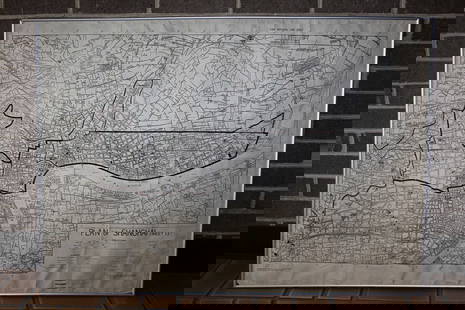
(ENGLAND.) Group of 6 eighteenth-century engraved maps
Similar Sale History
View More Items in Maps & AtlasesRelated Maps & Atlases
More Items in Maps & Atlases
View MoreRecommended Transportation & Travel Collectibles
View More


Item Details
Description
(ENGLAND.) Group of 6 eighteenth-century engraved maps of England. London, vd
Jefferys, Thomas. A New Map of England and Wales. 18x15 inches sheet size; original folds and binding trim at lower margin, light offsetting; London, circa 1760. * Morden, Robert. England. 15½x17¾ inches sheet size; light offsetting else fine; London, 1695. * Morden, Robert. Britannia Saxonica. 17x15½ inches sheet size; light offsetting, paper crinkle at right margin; London, 1722. * Bowen, Emanuel. A New and Accurate Map of Great Britain & Ireland, Together with Their Respective Islands &c. 16x17¾ inches sheet size; hand-colored in outline; very light foxing, small worm repair at upper margin; London, 1744. * Bowen, Emanuel. A New and Very Accurate Map of South Britain or England and Wales. 16x18¼ inches sheet size; hand-colored in outline; small worm repair at upper margin; London, 1744. * Darton, William (engraver). An Accurate Map of England and Wales with the Principal Roads. 18x14½ inches sheet size; original hand-color; small separation at fold; London: Dilly & Robinson, 1785.
Jefferys, Thomas. A New Map of England and Wales. 18x15 inches sheet size; original folds and binding trim at lower margin, light offsetting; London, circa 1760. * Morden, Robert. England. 15½x17¾ inches sheet size; light offsetting else fine; London, 1695. * Morden, Robert. Britannia Saxonica. 17x15½ inches sheet size; light offsetting, paper crinkle at right margin; London, 1722. * Bowen, Emanuel. A New and Accurate Map of Great Britain & Ireland, Together with Their Respective Islands &c. 16x17¾ inches sheet size; hand-colored in outline; very light foxing, small worm repair at upper margin; London, 1744. * Bowen, Emanuel. A New and Very Accurate Map of South Britain or England and Wales. 16x18¼ inches sheet size; hand-colored in outline; small worm repair at upper margin; London, 1744. * Darton, William (engraver). An Accurate Map of England and Wales with the Principal Roads. 18x14½ inches sheet size; original hand-color; small separation at fold; London: Dilly & Robinson, 1785.
Buyer's Premium
- 30%
(ENGLAND.) Group of 6 eighteenth-century engraved maps
Estimate $300 - $400
2 bidders are watching this item.
Shipping & Pickup Options
Item located in New York, NY, usOffers In-House Shipping
Local Pickup Available
Payment

Auction Curated By

Specialist, Maps & Atlases
Related Searches
TOP


![[MAPS]. A group of 9 early engraved maps and views, includi...: [MAPS]. A group of 9 early engraved maps and views, including: PORCACCHI, Tomaso. Descrittione Dell’Isola di S. Lorenzo. Venice, circa 1570s–1600s. Engraved and hand colored map vignette,](https://p1.liveauctioneers.com/928/252933/131521916_1_x.jpg?height=310&quality=70&version=1656110480)


![[MAP]. The Barnum & Bailey Tour of the United Kingdom, 1897...: [MAP]. The Barnum & Bailey Tour of the United Kingdom, 1897—98. Engraved map of England by W & A.K. Johnston, with Barnum & Bailey’s route printed in red, key at upper left with portraits](https://p1.liveauctioneers.com/928/259477/135055094_1_x.jpg?height=310&quality=70&version=1661545183)

![[MAPS]. ORTELIUS, Abraham. A group of 3 engraved maps with hand-coloring.: [MAPS]. ORTELIUS, Abraham (1527-1598). A group of 3 engraved maps with hand-coloring, comprising: Gallia Vetus. Antwerp, 1592. Latin text on verso. Van den Broecke Ort194 (1592L5). -- Wirtenberg Ducat](https://p1.liveauctioneers.com/197/329395/177650539_1_x.jpg?height=310&quality=70&version=1715364962)


![[MAP]. TODESCHI, Pietro. [Nova et Acurata Totius Americae Tabula auct. G.I. Blaeu] America quarta: [MAP]. TODESCHI, Pietro. [Nova et Acurata Totius Americae Tabula auct. G.I. Blaeu] America quarta pars orbis quam plerunq, nuvum orbem appellitant primo detecta est anno 1492 a Christophoro Columbo...](https://p1.liveauctioneers.com/197/329395/177650542_1_x.jpg?height=310&quality=70&version=1715364962)


![[MAPS]. HOMANN, Johann Baptist, HOMANN HEIRS, and Georg Matthäus SEUTTER. [Composite Atlas].: [MAPS]. HOMANN, Johann Baptist (1663-1724), HOMANN HEIRS, and Georg Matthäus SEUTTER (1678-1757). [Composite Atlas]. [Nuremberg, Augsburg, and others: Homann Heirs and others, maps dated between](https://p1.liveauctioneers.com/197/329395/177650530_1_x.jpg?height=310&quality=70&version=1715364962)


![[MAP]. ORTELIUS, Abraham. Turcici Imperii Descriptio.1592.: [MAP]. ORTELIUS, Abraham (1527-1598). Turcici Imperii Descriptio. Antwerp, 1592. Engraved map with hand-coloring. Matted, framed, and double glazed, sight 406 x 521 mm (unexamined out of frame). Decor](https://p1.liveauctioneers.com/197/329395/177650538_1_x.jpg?height=310&quality=70&version=1715364962)


