


Map of Mexico and Texas c.1845
Similar Sale History
View More Items in Maps & Atlases


Related Maps & Atlases


More Items in Maps & Atlases
View More


![[MAP]. TODESCHI, Pietro. [Nova et Acurata Totius Americae Tabula auct. G.I. Blaeu] America quarta: [MAP]. TODESCHI, Pietro. [Nova et Acurata Totius Americae Tabula auct. G.I. Blaeu] America quarta pars orbis quam plerunq, nuvum orbem appellitant primo detecta est anno 1492 a Christophoro Columbo...](https://p1.liveauctioneers.com/197/329395/177650542_1_x.jpg?height=310&quality=70&version=1715364962)


![[MAP]. ORTELIUS, Abraham. Americae Sive Novi Orbis, Nova Descriptio. 1573.: [MAP]. ORTELIUS, Abraham (1527-1598). Americae Sive Novi Orbis, Nova Descriptio. Antwerp, 1573. Engraved map with hand-coloring. Framed and double glazed, visible area 375 x 521 mm (unexamined out of](https://p1.liveauctioneers.com/197/329395/177650534_1_x.jpg?height=310&quality=70&version=1715364962)
![[MAPS]. HOMANN, Johann Baptist, HOMANN HEIRS, and Georg Matthäus SEUTTER. [Composite Atlas].: [MAPS]. HOMANN, Johann Baptist (1663-1724), HOMANN HEIRS, and Georg Matthäus SEUTTER (1678-1757). [Composite Atlas]. [Nuremberg, Augsburg, and others: Homann Heirs and others, maps dated between](https://p1.liveauctioneers.com/197/329395/177650530_1_x.jpg?height=310&quality=70&version=1715364962)


![[MAP]. ORTELIUS, Abraham. Turcici Imperii Descriptio.1592.: [MAP]. ORTELIUS, Abraham (1527-1598). Turcici Imperii Descriptio. Antwerp, 1592. Engraved map with hand-coloring. Matted, framed, and double glazed, sight 406 x 521 mm (unexamined out of frame). Decor](https://p1.liveauctioneers.com/197/329395/177650538_1_x.jpg?height=310&quality=70&version=1715364962)

![[MAP]. ORTELIUS, Abraham. Aevi Veteris, Typus Geographicus. 1601.: [MAP]. ORTELIUS, Abraham (1527-1598). Aevi Veteris, Typus Geographicus. Antwerp, 1601. Engraved map with hand-coloring. Matted, framed, and double glazed, visible area 343 x 470 mm (unexamined out of](https://p1.liveauctioneers.com/197/329395/177650532_1_x.jpg?height=310&quality=70&version=1715364962)

Recommended Transportation & Travel Collectibles
View More


![[FLAGS]. 31-star American parade flag. Ca 1850-1859.: [FLAGS]. 31-star American parade flag. Ca 1850-1859. 22 x 36 1/2 in. cotton flag with 31 printed stars, configured in a double medallion surrounding a much larger central star, that is haloed in both](https://p1.liveauctioneers.com/197/329785/177758218_1_x.jpg?height=310&quality=70&version=1715625218)


Item Details
Description
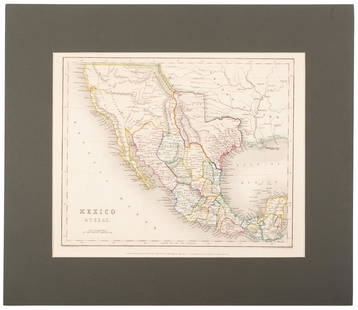
Heading: (Texas)
Author: Wyld, James
Title: Republic of Mexico and Texas
Place Published: London
Publisher:
Date Published: c.1845
Description:
Author: Wyld, James
Title: Republic of Mexico and Texas
Place Published: London
Publisher:
Date Published: c.1845
Description:
Engraved map, with Mexico portion hand-colored 22.5x27.2 cm (8¾x10¾"), matted.
The dotted borders indicate Texas as separate from the United States and from Mexico, in maximum configuration including Santa Fé, but the coloring shows Texas, and westward to the Pacific, to be part of the United States, with border in pre-Gadsden configuration. Perhaps this is a later issue of the map with coloring executed to reflect the political evolution.
Condition
Very good or better condition.
Buyer's Premium
- 25%
Map of Mexico and Texas c.1845
Estimate $200 - $300
4 bidders are watching this item.
Shipping & Pickup Options
Item located in Berkeley, CA, usOffers In-House Shipping
Local Pickup Available
Payment

Related Searches
TOP