


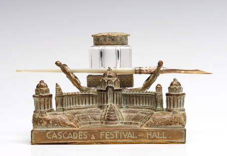
World chart with ship's route in ink, 1861
Similar Sale History
View More Items in Desk Accessories


Related Desk Accessories


More Items in Desk Accessories
View More


![RICHARD SATAVA (B.1975) STUDIO ART GLASS LAMPWORK JELLYFISH PAPERWEIGHT: Studio art glass lampwork jellyfish paperweight, signed Satava (Richard Satava, American, b.1950), dated [20]01, colorless glass encasing semi-translucent jellyfish with thin ribbon tentacles, numbere](https://p1.liveauctioneers.com/21/328526/176979688_1_x.jpg?height=310&quality=70&version=1714678704)


Recommended Decorative Objects
View More


Item Details
Description
Heading:
Author: Hobbs, J.S.
Title: A General Chart for the purpose of pricking off a Ship's Tract, from England, &c., Southward and Round the World
Place Published: London
Publisher:Charles Wilson
Date Published: 1861
Description:
Author: Hobbs, J.S.
Title: A General Chart for the purpose of pricking off a Ship's Tract, from England, &c., Southward and Round the World
Place Published: London
Publisher:Charles Wilson
Date Published: 1861
Description:
Engraved map printed on 4 sheers joined together, backed with linen and sectioned for folding into cloth covers. 160.5x82.8 cm (63½x32½").
World chart designed for tracing the track of a voyage. In this instance, the track of the S.S. Armenian is neatly traced in ink, with dates. Departed Calcutta, 1860 April 8th to Singapore, Hainan, Hongkong, arriving May 15. Left Hongkong, Dec 21, 1860, to Singapore, Capetown, Portsmouth, arriving May 14 1861. The track lays down the position day by day from Hongkong to Portsmouth. Note the starting date is 1860, raising the question, was this track laid down afterward or was the map predated? On verso of map the signature of J.G. Leadbitter 1861.
Condition
Very good or better condition.
Buyer's Premium
- 25%
World chart with ship's route in ink, 1861
Estimate $300 - $500
4 bidders are watching this item.
Get approved to bid.
Shipping & Pickup Options
Item located in Berkeley, CA, usOffers In-House Shipping
Local Pickup Available
Payment

TOP