


1886 Bradley map of Florida
Similar Sale History
View More Items in Maps & Atlases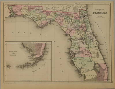


![[MANUSCRIPT MAP-FLORIDA & MISSISSIPPI RIVER] Map Showing Raiford's Proposed Artificial River and: [MANUSCRIPT MAP-FLORIDA & MISSISSIPPI RIVER] Map Showing Raiford's Proposed Artificial River and Plan to Continue the Western and Southern Inland System of Navigation to Harbors in the Atlantic. [Fern](https://p1.liveauctioneers.com/292/250642/130213644_1_x.jpg?height=310&quality=70&version=1654271664)
![[MAP-FLORIDA] VANDERMAELEN, PHILIPPE MARIE. Florides et Iles Lucayes. [Brussels:] August 1825.: [MAP-FLORIDA] VANDERMAELEN, PHILIPPE MARIE. Florides et Iles Lucayes. [Brussels:] August 1825. Lithographed map with hand-color. Lithographed by H. Ode. 19 1/4 x 21 1/2 inches (49 x 55 cm); matted and](https://p1.liveauctioneers.com/292/250642/130213663_1_x.jpg?height=310&quality=70&version=1654271664)


Related Maps & Atlases


More Items in Maps & Atlases
View More


![[MAP]. TODESCHI, Pietro. [Nova et Acurata Totius Americae Tabula auct. G.I. Blaeu] America quarta: [MAP]. TODESCHI, Pietro. [Nova et Acurata Totius Americae Tabula auct. G.I. Blaeu] America quarta pars orbis quam plerunq, nuvum orbem appellitant primo detecta est anno 1492 a Christophoro Columbo...](https://p1.liveauctioneers.com/197/329395/177650542_1_x.jpg?height=310&quality=70&version=1715364962)

![[MAPS]. HOMANN, Johann Baptist, HOMANN HEIRS, and Georg Matthäus SEUTTER. [Composite Atlas].: [MAPS]. HOMANN, Johann Baptist (1663-1724), HOMANN HEIRS, and Georg Matthäus SEUTTER (1678-1757). [Composite Atlas]. [Nuremberg, Augsburg, and others: Homann Heirs and others, maps dated between](https://p1.liveauctioneers.com/197/329395/177650530_1_x.jpg?height=310&quality=70&version=1715364962)

![[MAP]. ORTELIUS, Abraham. Americae Sive Novi Orbis, Nova Descriptio. 1573.: [MAP]. ORTELIUS, Abraham (1527-1598). Americae Sive Novi Orbis, Nova Descriptio. Antwerp, 1573. Engraved map with hand-coloring. Framed and double glazed, visible area 375 x 521 mm (unexamined out of](https://p1.liveauctioneers.com/197/329395/177650534_1_x.jpg?height=310&quality=70&version=1715364962)


![[MAP]. ORTELIUS, Abraham. Turcici Imperii Descriptio.1592.: [MAP]. ORTELIUS, Abraham (1527-1598). Turcici Imperii Descriptio. Antwerp, 1592. Engraved map with hand-coloring. Matted, framed, and double glazed, sight 406 x 521 mm (unexamined out of frame). Decor](https://p1.liveauctioneers.com/197/329395/177650538_1_x.jpg?height=310&quality=70&version=1715364962)

![[MAP]. ORTELIUS, Abraham. Aevi Veteris, Typus Geographicus. 1601.: [MAP]. ORTELIUS, Abraham (1527-1598). Aevi Veteris, Typus Geographicus. Antwerp, 1601. Engraved map with hand-coloring. Matted, framed, and double glazed, visible area 343 x 470 mm (unexamined out of](https://p1.liveauctioneers.com/197/329395/177650532_1_x.jpg?height=310&quality=70&version=1715364962)
Recommended Transportation & Travel Collectibles
View More


![[FLAGS]. 31-star American parade flag. Ca 1850-1859.: [FLAGS]. 31-star American parade flag. Ca 1850-1859. 22 x 36 1/2 in. cotton flag with 31 printed stars, configured in a double medallion surrounding a much larger central star, that is haloed in both](https://p1.liveauctioneers.com/197/329785/177758218_1_x.jpg?height=310&quality=70&version=1715625218)


Item Details
Description
Antique hand colored map of Florida, with counties delineated by color, and inset map of the southern portion of Florida. Published by M. Bradley in Mitchell’s 1887 New General Atlas. Shows forts, rivers, towns, lakes, etc. Includes topographical detail and railroads. Extremely clean and presentable. 10.875 x 14.375.
Reserve: $55.00
Shipping:Domestic: Flat-rate of $8.00 to anywhere within the contiguous U.S. International: Foreign shipping rates are determined by destination. Combined shipping: Please ask about combined shipping for multiple lots before bidding. Location: This item ships fromOhio
Your purchase is protected:
Photos, descriptions, and estimates were prepared with the utmost care by a fully certified expert and appraiser. All items in this sale are guaranteed authentic.
In the rare event that the item did not conform to the lot description in the sale, Jasper52 specialists are here to help. Buyers may return the item for a full refund provided you notify Jasper52 within 5 days of receiving the item.
Reserve: $55.00
Shipping:
Your purchase is protected:
Photos, descriptions, and estimates were prepared with the utmost care by a fully certified expert and appraiser. All items in this sale are guaranteed authentic.
In the rare event that the item did not conform to the lot description in the sale, Jasper52 specialists are here to help. Buyers may return the item for a full refund provided you notify Jasper52 within 5 days of receiving the item.
Buyer's Premium
- 15%
1886 Bradley map of Florida
Estimate $70 - $80
3 bidders are watching this item.
Get approved to bid.
Shipping & Pickup Options
Item located in Ohio, US$8 shipping in the US
Payment
See More Items From This Jasper52 Seller

Auction Curated By

Maps Expert
Related Searches
TOP