


Buchon: Encyclopedic Map of 1820s New Hampshire
Similar Sale History
View More Items in Maps & Atlases


Related Maps & Atlases


![Pocket Map of Richland Co., OH c1910 [180795]: Pocket map - "New Road Map of Richland County, Ohio." Published by The Daily Globe, Shelby, OH, c1910. Map measures 21" x 30". Please see photo(s) for more details. Richland County Ohio](https://p1.liveauctioneers.com/2699/331495/178785767_1_x.jpg?height=310&quality=70&version=1717094933)


![1902 Cram Map of New York City [verso] Washington DC [verso] Baltimore -- New York [verso]: Title: 1902 Cram Map of New York City [verso] Washington DC [verso] Baltimore -- New York [verso] Washington] and [verso] Baltimore Cartographer: G Cram Year / Place: 1902, Chicago Map Dimension (in.)](https://p1.liveauctioneers.com/5584/331064/178466310_1_x.jpg?height=310&quality=70&version=1716924723)


![Pyramid Lake Print Pair & 1885 NM & UT Territory Map [179398]: 1855 J H Colton hand colored map of New Mexico and Utah Territories, complete with Pyramid Lake in a shape that is very different as compared to the lake today. Did the cartographer mess up or has the](https://p1.liveauctioneers.com/2699/331495/178785761_1_x.jpg?height=310&quality=70&version=1717094933)
![Jacob Monk 1853 Map of North America [173506]: Large wall map, typical nvarnish finish, mounted to board for viewing. "New map of that portion of North America exhibiting the United States and Territories, the Canadas, New Brunswick, Nova Scotia,](https://p1.liveauctioneers.com/2699/331495/178785775_1_x.jpg?height=310&quality=70&version=1717094933)


More Items in Maps & Atlases
View More![[MAP]. TODESCHI, Pietro. [Nova et Acurata Totius Americae Tabula auct. G.I. Blaeu] America quarta: [MAP]. TODESCHI, Pietro. [Nova et Acurata Totius Americae Tabula auct. G.I. Blaeu] America quarta pars orbis quam plerunq, nuvum orbem appellitant primo detecta est anno 1492 a Christophoro Columbo...](https://p1.liveauctioneers.com/197/329395/177650542_1_x.jpg?height=310&quality=70&version=1715364962)
![[MAPS]. HOMANN, Johann Baptist, HOMANN HEIRS, and Georg Matthäus SEUTTER. [Composite Atlas].: [MAPS]. HOMANN, Johann Baptist (1663-1724), HOMANN HEIRS, and Georg Matthäus SEUTTER (1678-1757). [Composite Atlas]. [Nuremberg, Augsburg, and others: Homann Heirs and others, maps dated between](https://p1.liveauctioneers.com/197/329395/177650530_1_x.jpg?height=310&quality=70&version=1715364962)


![[MAP]. ORTELIUS, Abraham. Americae Sive Novi Orbis, Nova Descriptio. 1573.: [MAP]. ORTELIUS, Abraham (1527-1598). Americae Sive Novi Orbis, Nova Descriptio. Antwerp, 1573. Engraved map with hand-coloring. Framed and double glazed, visible area 375 x 521 mm (unexamined out of](https://p1.liveauctioneers.com/197/329395/177650534_1_x.jpg?height=310&quality=70&version=1715364962)

![Set of Twelve Satirical Anthropomorphic Maps of Europe: [SATIRICAL MAPS] A set of twelve satirical anthropomorphic maps of Europe. London: circa 1868. A set of 12 (believed complete) lithographed maps by Vincent Brooks, Day & Son, London, each offering](https://p1.liveauctioneers.com/292/330597/178279264_1_x.jpg?height=310&quality=70&version=1716409282)


![[MAP]. ORTELIUS, Abraham. Turcici Imperii Descriptio.1592.: [MAP]. ORTELIUS, Abraham (1527-1598). Turcici Imperii Descriptio. Antwerp, 1592. Engraved map with hand-coloring. Matted, framed, and double glazed, sight 406 x 521 mm (unexamined out of frame). Decor](https://p1.liveauctioneers.com/197/329395/177650538_1_x.jpg?height=310&quality=70&version=1715364962)
![[MAP]. ORTELIUS, Abraham. Romani Imperii Imago. 1592.: [MAP]. ORTELIUS, Abraham (1527-1598). Romani Imperii Imago. Antwerp, 1592. Engraved map with hand-coloring. Matted, framed, and double glazed, visible area 381 x 521 mm (unexamined out of frame). 6 de](https://p1.liveauctioneers.com/197/329395/177650537_1_x.jpg?height=310&quality=70&version=1715364962)
![[MAP]. SPEED, John. A New Mappe of the Romane Empire. 1676.: [MAP]. SPEED, John (ca 1551-1629). A New Mappe of the Romane Empire. London: Basset & Chiswell, 1676. Engraved map with hand-coloring. Framed and double glazed, sight 419 x 559 mm. Decorative cartouch](https://p1.liveauctioneers.com/197/329395/177650541_1_x.jpg?height=310&quality=70&version=1715364962)

![[MAP]. ORTELIUS, Abraham. Aevi Veteris, Typus Geographicus. 1601.: [MAP]. ORTELIUS, Abraham (1527-1598). Aevi Veteris, Typus Geographicus. Antwerp, 1601. Engraved map with hand-coloring. Matted, framed, and double glazed, visible area 343 x 470 mm (unexamined out of](https://p1.liveauctioneers.com/197/329395/177650532_1_x.jpg?height=310&quality=70&version=1715364962)
Recommended Transportation & Travel Collectibles
View More


Item Details
Description
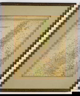
The New Hampshire sheet from the Atlas Geographique, Statistique, Historique, et Cronologique des Deux Ameriques, the French version of Carey & Lea's American Atlas, published in Paris by J. Carez. Beautifully colored by county, the highly detailed and accurate map of New Hampshire is surrounded on three sides by text describing the state and its geography, "natural curiosities," climate, population by county, principal cities, economy, religion, government,and history, plus a list of governors and famous battle sites (just one: Dover).
Reserve: $30.00
Shipping:
Your purchase is protected:
Photos, descriptions, and estimates were prepared with the utmost care by a fully certified expert and appraiser. All items in this sale are guaranteed authentic.
In the rare event that the item did not conform to the lot description in the sale, Jasper52 specialists are here to help. Buyers may return the item for a full refund provided you notify Jasper52 within 5 days of receiving the item.
Condition
wash color; light overall age toning; a few minor spots and very light browning along outer edges of margins; otherwise a beautifully preserved exemplar
Buyer's Premium
- 15%
Buchon: Encyclopedic Map of 1820s New Hampshire
Estimate $40 - $50
1 bidder is watching this item.
Shipping & Pickup Options
Item located in New York, US$15 shipping in the US
Payment
Accepts seamless payments through LiveAuctioneers
See More Items From This Jasper52 Seller

Auction Curated By

Maps Expert
Related Searches
TOP