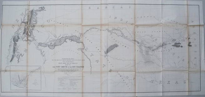
1853-4 Whipple Map of Parts of Arkansas, Indian
Similar Sale History
View More Items in Maps & Atlases

Related Maps & Atlases
More Items in Maps & Atlases
View MoreRecommended Transportation & Travel Collectibles
View More


Item Details
Description
This large survey map, prepared for the Union Pacific originally, shows the region from Fort Smith, Arkansas, including Indian Territory, Texas to Isleta, a tiny Indian pueblo on the Rio Grande in New Mexico. Forts, mounds, trading posts, the Santa Fe Trail, Raton Pass, Taos and Santa Fe are all located. Wheat calls this map noteworthy for it use of the contour system. The inset map is Sketch of Rio Pecos at Anton Chico, and it is the first map of this type to use the contour system. The map also features a long list of authorities and surveys used for related topography, excluding this survey.
Please note that this lot has a confidential reserve. When you leave a bid in advance of the auction, submit your maximum. The bidder who has submitted the highest bid wins the lot, provided the bid exceeds the reserve price.
Shipping:
Your purchase is protected:
Photos, descriptions, and estimates were prepared with the utmost care by a fully certified expert and appraiser. All items in this sale are guaranteed authentic.
In the rare event that the item did not conform to the lot description in the sale, Jasper52 specialists are here to help. Buyers may return the item for a full refund provided you notify Jasper52 within 5 days of receiving the item.
Condition
Good. Toning in issued folds. Several splits (longest ca. 7 in.) in folds, most small. Uncolored. Printed on two joined sheets, as issued.
Buyer's Premium
- 15%
1853-4 Whipple Map of Parts of Arkansas, Indian
Estimate $200 - $250
2 bidders are watching this item.
Get approved to bid.
Shipping & Pickup Options
Item located in Ohio, US$12 shipping in the US
Payment
See More Items From This Jasper52 Seller

Auction Curated By

Maps Expert
TOP


![Large Map of Texas (Western Part): Large Map of Texas (Western Part) With map of Louisiana and Arkansas [separately] on versos Cartographer: George Franklin Cram Dated: Circa 1900 Type: Color Lithograph Dime](https://p1.liveauctioneers.com/5614/330257/178045313_1_x.jpg?height=310&quality=70&version=1716032806)

![Early French Map of Great Lakes [179300]: Early French (circa 1780s) map of the Great Lakes region and parts of Canada. Map, a double truck page from a book, measures 9"x 13" and shows the various Indian tribes in the area, including the Algo](https://p1.liveauctioneers.com/2699/331495/178785744_1_x.jpg?height=310&quality=70&version=1717094933)

![French Map of America Southwest & Mexico [179298]: French map the American Southwest and Mexico. This is a double truck from an 18th century book and measures 10x 14". Map from 1787 during the reign of Louie XVI the king France who beheaded in1793.Riv](https://p1.liveauctioneers.com/2699/331495/178785763_1_x.jpg?height=310&quality=70&version=1717094933)
![Early French Map of East Coast & Canada [179301]: This is a circa 1790 French map of the Eastern Seaboard of America and parts of Canada. Landmarks and waterways are clearly marked as are the territories inhabited by Indian tribes, including the Iroq](https://p1.liveauctioneers.com/2699/331495/178785745_1_x.jpg?height=310&quality=70&version=1717094933)


![West Africa. Sahara caravan routes. Tribes Kingdoms Empires. LIZARS 1842 map: Title: West Africa. Sahara caravan routes. Tribes Kingdoms Empires. LIZARS 1842 map Description: Part of Africa [north-west sheet] by William Home Lizars (1842). Antique 19th century atlas map with or](https://p1.liveauctioneers.com/5584/330582/178266304_1_x.jpg?height=310&quality=70&version=1716924723)


![Maps of Asia & India, c1800's (2) [180164]: (2) Maps of Asia, from atlas, c. 1800's. The First is a map of the continent of Asia, highlighting the Russian Empire and the Chinese empire. Map legend includes "Geographical miles", "British Miles",](https://p1.liveauctioneers.com/2699/331495/178785787_1_x.jpg?height=310&quality=70&version=1717094933)


![[MAP]. TODESCHI, Pietro. [Nova et Acurata Totius Americae Tabula auct. G.I. Blaeu] America quarta: [MAP]. TODESCHI, Pietro. [Nova et Acurata Totius Americae Tabula auct. G.I. Blaeu] America quarta pars orbis quam plerunq, nuvum orbem appellitant primo detecta est anno 1492 a Christophoro Columbo...](https://p1.liveauctioneers.com/197/329395/177650542_1_x.jpg?height=310&quality=70&version=1715364962)

![[MAPS]. HOMANN, Johann Baptist, HOMANN HEIRS, and Georg Matthäus SEUTTER. [Composite Atlas].: [MAPS]. HOMANN, Johann Baptist (1663-1724), HOMANN HEIRS, and Georg Matthäus SEUTTER (1678-1757). [Composite Atlas]. [Nuremberg, Augsburg, and others: Homann Heirs and others, maps dated between](https://p1.liveauctioneers.com/197/329395/177650530_1_x.jpg?height=310&quality=70&version=1715364962)


![[MAP]. ORTELIUS, Abraham. Americae Sive Novi Orbis, Nova Descriptio. 1573.: [MAP]. ORTELIUS, Abraham (1527-1598). Americae Sive Novi Orbis, Nova Descriptio. Antwerp, 1573. Engraved map with hand-coloring. Framed and double glazed, visible area 375 x 521 mm (unexamined out of](https://p1.liveauctioneers.com/197/329395/177650534_1_x.jpg?height=310&quality=70&version=1715364962)

![Set of Twelve Satirical Anthropomorphic Maps of Europe: [SATIRICAL MAPS] A set of twelve satirical anthropomorphic maps of Europe. London: circa 1868. A set of 12 (believed complete) lithographed maps by Vincent Brooks, Day & Son, London, each offering](https://p1.liveauctioneers.com/292/330597/178279264_1_x.jpg?height=310&quality=70&version=1716409282)


![[MAP]. ORTELIUS, Abraham. Turcici Imperii Descriptio.1592.: [MAP]. ORTELIUS, Abraham (1527-1598). Turcici Imperii Descriptio. Antwerp, 1592. Engraved map with hand-coloring. Matted, framed, and double glazed, sight 406 x 521 mm (unexamined out of frame). Decor](https://p1.liveauctioneers.com/197/329395/177650538_1_x.jpg?height=310&quality=70&version=1715364962)
![[MAP]. ORTELIUS, Abraham. Romani Imperii Imago. 1592.: [MAP]. ORTELIUS, Abraham (1527-1598). Romani Imperii Imago. Antwerp, 1592. Engraved map with hand-coloring. Matted, framed, and double glazed, visible area 381 x 521 mm (unexamined out of frame). 6 de](https://p1.liveauctioneers.com/197/329395/177650537_1_x.jpg?height=310&quality=70&version=1715364962)
![[MAP]. SPEED, John. A New Mappe of the Romane Empire. 1676.: [MAP]. SPEED, John (ca 1551-1629). A New Mappe of the Romane Empire. London: Basset & Chiswell, 1676. Engraved map with hand-coloring. Framed and double glazed, sight 419 x 559 mm. Decorative cartouch](https://p1.liveauctioneers.com/197/329395/177650541_1_x.jpg?height=310&quality=70&version=1715364962)


![[FLAGS]. 31-star American parade flag. Ca 1850-1859.: [FLAGS]. 31-star American parade flag. Ca 1850-1859. 22 x 36 1/2 in. cotton flag with 31 printed stars, configured in a double medallion surrounding a much larger central star, that is haloed in both](https://p1.liveauctioneers.com/197/329785/177758218_1_x.jpg?height=310&quality=70&version=1715625218)


![[FLAGS]. 13-star American flag, possibly a US Navy boat flag. Ca late-19th century.: [FLAGS]. 13-star American flag, possibly a US Navy boat flag. Ca late-19th century. 35 x 71 1/2 in. hand-sewn and machine-sewn wool flag with 13 double-appliquéd cotton stars configured in 3/2/3/2/3](https://p1.liveauctioneers.com/197/329785/177758215_1_x.jpg?height=310&quality=70&version=1715625218)


