


Asia mapped by Mercator the younger, 1619
Similar Sale History
View More Items in Maps & Atlases

![EUROPAE. [Ortelius, Ca. 1584-1612.] Map.: [Ortelius, Abraham] EUROPAE. [C. 1584-1612.] Engraved map by Ortelius based on Jenkinson’s Russia map and Gastaldi’s maps of Africa and Asia, Gerard Mercator’s 1564 map of Britain, a map of Scan](https://p1.liveauctioneers.com/179/82189/42599765_1_x.jpg?height=310&quality=70&version=1447864785)


![Mercator World Map: *** START PRICE IS THE RESERVE *** [World] MERCATOR, Rumold (1545-1599). Orbis Terrae Compendiosa Descriptio Quam ex Magna Universali Mercatoris... Engraved Map with original hand color. Geneva, 1587.](https://p1.liveauctioneers.com/1968/163248/82424686_1_x.jpg?height=310&quality=70&version=1583340284)


Related Maps & Atlases


More Items in Maps & Atlases
View More


![[MAP]. TODESCHI, Pietro. [Nova et Acurata Totius Americae Tabula auct. G.I. Blaeu] America quarta: [MAP]. TODESCHI, Pietro. [Nova et Acurata Totius Americae Tabula auct. G.I. Blaeu] America quarta pars orbis quam plerunq, nuvum orbem appellitant primo detecta est anno 1492 a Christophoro Columbo...](https://p1.liveauctioneers.com/197/329395/177650542_1_x.jpg?height=310&quality=70&version=1715364962)


![[MAPS]. HOMANN, Johann Baptist, HOMANN HEIRS, and Georg Matthäus SEUTTER. [Composite Atlas].: [MAPS]. HOMANN, Johann Baptist (1663-1724), HOMANN HEIRS, and Georg Matthäus SEUTTER (1678-1757). [Composite Atlas]. [Nuremberg, Augsburg, and others: Homann Heirs and others, maps dated between](https://p1.liveauctioneers.com/197/329395/177650530_1_x.jpg?height=310&quality=70&version=1715364962)

![[MAP]. ORTELIUS, Abraham. Americae Sive Novi Orbis, Nova Descriptio. 1573.: [MAP]. ORTELIUS, Abraham (1527-1598). Americae Sive Novi Orbis, Nova Descriptio. Antwerp, 1573. Engraved map with hand-coloring. Framed and double glazed, visible area 375 x 521 mm (unexamined out of](https://p1.liveauctioneers.com/197/329395/177650534_1_x.jpg?height=310&quality=70&version=1715364962)


![[MAP]. ORTELIUS, Abraham. Turcici Imperii Descriptio.1592.: [MAP]. ORTELIUS, Abraham (1527-1598). Turcici Imperii Descriptio. Antwerp, 1592. Engraved map with hand-coloring. Matted, framed, and double glazed, sight 406 x 521 mm (unexamined out of frame). Decor](https://p1.liveauctioneers.com/197/329395/177650538_1_x.jpg?height=310&quality=70&version=1715364962)

![[MAP]. ORTELIUS, Abraham. Aevi Veteris, Typus Geographicus. 1601.: [MAP]. ORTELIUS, Abraham (1527-1598). Aevi Veteris, Typus Geographicus. Antwerp, 1601. Engraved map with hand-coloring. Matted, framed, and double glazed, visible area 343 x 470 mm (unexamined out of](https://p1.liveauctioneers.com/197/329395/177650532_1_x.jpg?height=310&quality=70&version=1715364962)
Recommended Transportation & Travel Collectibles
View More


![[FLAGS]. 31-star American parade flag. Ca 1850-1859.: [FLAGS]. 31-star American parade flag. Ca 1850-1859. 22 x 36 1/2 in. cotton flag with 31 printed stars, configured in a double medallion surrounding a much larger central star, that is haloed in both](https://p1.liveauctioneers.com/197/329785/177758218_1_x.jpg?height=310&quality=70&version=1715625218)


Item Details
Description
Heading:
Author: Mercator, Gerard, the younger
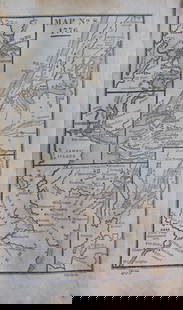
Title: Asia ex Magna Orbis Terre Descriptione Gerardi Mercatoris Desumpta, Studio et Industria G.M. Iunioris
Place Published: Amsterdam
Publisher:
Date Published: 1606-[1619]
Description:
Author: Mercator, Gerard, the younger
Title: Asia ex Magna Orbis Terre Descriptione Gerardi Mercatoris Desumpta, Studio et Industria G.M. Iunioris
Place Published: Amsterdam
Publisher:
Date Published: 1606-[1619]
Description:
Copper-engraved map, hand-colored. 37.5x46.5 cm. (14¾x18¼").
Map of Asia derived from Gerard Mercator the elder's world map of 1569, engraved by his grandson. ;The coasts of Northeast Asia and Northwest North America are separated by Gastaldi's fabled Strait of Anian. South of this strait a beautifully engraved galleon gives speculation to the possibility of a northern route to Asia. Sumatra has a curiously archaic outline, while the relationship between New Guinea and Terra Australis undetermined - perhaps they are joined beyond the map parameters. This map is from the 1619 edition of the Mercator-Hondlus atlas. French text on verso. ; ;
Condition
Some toning and light foxing, discoloration in margins; very good.
Buyer's Premium
- 25%
Asia mapped by Mercator the younger, 1619
Estimate $1,000 - $1,500
5 bidders are watching this item.
Shipping & Pickup Options
Item located in San Francisco, CA, usSee Policy for Shipping
Payment

Related Searches
TOP