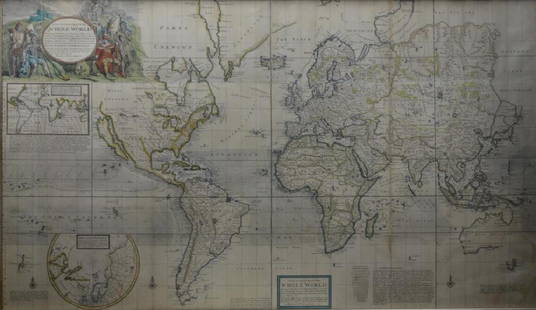
FRAMED MAP OF THE WORLD FROM CAREY'S ATLAS OF 1795,
Similar Sale History
View More Items in Maps & AtlasesRelated Maps & Atlases
More Items in Maps & Atlases
View MoreRecommended Transportation & Travel Collectibles
View More


Item Details
Description
"A Chart of the World According to Mercator's Projection. Shewing the latest Discoveries of Capt. Cook", by Matthew Carey, Philadelphia, 1795, one of the earliest maps of the world published in the United States. Copperplate engraving on wove paper with hand coloring. Possibly a reworking of an earlier plate from Guthrie's Geography, London, 1795. In wooden molded frame, linen mat with second window for tag, under glass, OS: 22" x 25", SS: 14 1/2" x 18 1/2". Appears to be laid down, bubbling at vertical center joint, light foxing.
Buyer's Premium
- 20%
FRAMED MAP OF THE WORLD FROM CAREY'S ATLAS OF 1795,
Estimate $800 - $1,200
1 bidder is watching this item.
Get approved to bid.
Shipping & Pickup Options
Item located in Thomaston, ME, usSee Policy for Shipping
Payment

TOP


![[MAP]. ORTELIUS, Abraham. Aevi Veteris, Typus Geographicus. 1601.: [MAP]. ORTELIUS, Abraham (1527-1598). Aevi Veteris, Typus Geographicus. Antwerp, 1601. Engraved map with hand-coloring. Matted, framed, and double glazed, visible area 343 x 470 mm (unexamined out of](https://p1.liveauctioneers.com/197/329395/177650532_1_x.jpg?height=310&quality=70&version=1715364962)


![Large Map of Alaska: Large Map of Alaska With map of Washington and Oregon [separately] on versos Cartographer: George Franklin Cram Dated: Circa 1900 Type: Color Lithograph Dimensions: 14](https://p1.liveauctioneers.com/5614/330257/178045317_1_x.jpg?height=310&quality=70&version=1716032806)

![Large Map of Texas (Western Part): Large Map of Texas (Western Part) With map of Louisiana and Arkansas [separately] on versos Cartographer: George Franklin Cram Dated: Circa 1900 Type: Color Lithograph Dime](https://p1.liveauctioneers.com/5614/330257/178045313_1_x.jpg?height=310&quality=70&version=1716032806)
![Large Map of Hawaiian Islands & Porto Rico: Large Map of Porto Rico With map of Hawaii - Hawaiian Islands and Samoa [separately] on versos] Cartographer: George Franklin Cram Dated: Circa 1900 Type: Color Lithograph](https://p1.liveauctioneers.com/5614/330257/178045318_1_x.jpg?height=310&quality=70&version=1716032806)
![Large Map of Montana: Large Map of Montana With map of Utah and Wyoming [separately] on versos Cartographer: George Franklin Cram Dated: Circa 1900 Type: Color Lithograph Dimensions: 14 1/2](https://p1.liveauctioneers.com/5614/330257/178045315_1_x.jpg?height=310&quality=70&version=1716032806)
![Large Map of California: Large Map of California With map of Arizona and Nevada [separately] on versos Cartographer: George Franklin Cram Dated: Circa 1900 Type: Color Lithograph Dimensions: 14](https://p1.liveauctioneers.com/5614/330257/178045314_1_x.jpg?height=310&quality=70&version=1716032806)
![Large Map of Texas (Eastern Part): Large Map of Texas (Eastern Part) With map of Alabama and Mississippi [separately] on versos Cartographer: George Franklin Cram Dated: Circa 1900 Type: Color Lithograph Dim](https://p1.liveauctioneers.com/5614/330257/178045312_1_x.jpg?height=310&quality=70&version=1716032806)
![Large Map of Kentucky and Tennessee: Large Map of Kentucky and Tennessee With map of North Dakota and South Dakota [separately] on versos Cartographer: George Franklin Cram Dated: Circa 1900 Type: Color Lithograph](https://p1.liveauctioneers.com/5614/330257/178045311_1_x.jpg?height=310&quality=70&version=1716032806)

![Large Map of Michigan and Wisconsin: Large Map of Michigan and Wisconsin With map of Kansas and Nebraska [separately] on versos Cartographer: George Franklin Cram Dated: Circa 1900 Type: Color Lithograph Dimen](https://p1.liveauctioneers.com/5614/330257/178045309_1_x.jpg?height=310&quality=70&version=1716032806)


![[MAP]. TODESCHI, Pietro. [Nova et Acurata Totius Americae Tabula auct. G.I. Blaeu] America quarta: [MAP]. TODESCHI, Pietro. [Nova et Acurata Totius Americae Tabula auct. G.I. Blaeu] America quarta pars orbis quam plerunq, nuvum orbem appellitant primo detecta est anno 1492 a Christophoro Columbo...](https://p1.liveauctioneers.com/197/329395/177650542_1_x.jpg?height=310&quality=70&version=1715364962)


![[MAPS]. HOMANN, Johann Baptist, HOMANN HEIRS, and Georg Matthäus SEUTTER. [Composite Atlas].: [MAPS]. HOMANN, Johann Baptist (1663-1724), HOMANN HEIRS, and Georg Matthäus SEUTTER (1678-1757). [Composite Atlas]. [Nuremberg, Augsburg, and others: Homann Heirs and others, maps dated between](https://p1.liveauctioneers.com/197/329395/177650530_1_x.jpg?height=310&quality=70&version=1715364962)


![[MAP]. ORTELIUS, Abraham. Turcici Imperii Descriptio.1592.: [MAP]. ORTELIUS, Abraham (1527-1598). Turcici Imperii Descriptio. Antwerp, 1592. Engraved map with hand-coloring. Matted, framed, and double glazed, sight 406 x 521 mm (unexamined out of frame). Decor](https://p1.liveauctioneers.com/197/329395/177650538_1_x.jpg?height=310&quality=70&version=1715364962)


