


Santini/Vaugondy: Antique Map of Asia, 1784
Similar Sale History
View More Items in Maps & Atlases


Related Maps & Atlases


![Afrique Ancienne. Ancient North Africa. MALTE-BRUN c1871 old antique map chart: Title: Afrique Ancienne. Ancient North Africa. MALTE-BRUN c1871 old antique map chart Description: Afrique Ancienne [Ancient Africa] by P Bellier Impr. Pierre Sarrazin (c1871). Antique 19th century en](https://p1.liveauctioneers.com/5584/330582/178266350_1_x.jpg?height=310&quality=70&version=1716924723)


More Items in Asian Maps & Atlases
View More


Recommended Transportation & Travel Collectibles
View More


![[MAPS]. HOMANN, Johann Baptist, HOMANN HEIRS, and Georg Matthäus SEUTTER. [Composite Atlas].: [MAPS]. HOMANN, Johann Baptist (1663-1724), HOMANN HEIRS, and Georg Matthäus SEUTTER (1678-1757). [Composite Atlas]. [Nuremberg, Augsburg, and others: Homann Heirs and others, maps dated between](https://p1.liveauctioneers.com/197/329395/177650530_1_x.jpg?height=310&quality=70&version=1715364962)


Item Details
Description
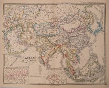
TITLE/CONTENT OF MAP: 'L'Asie divisée en ses principaux Etats assujettie aux observations astronomiq par le Sr. Janvier Géographe. À Venise Chez Francois Santini rue St. Justine Prés la ditte Eglise Chez. Mr. Remondini [Asia divided into its principal states]'
A decorative 18th century map of Asia, including the East Indies, the Arabian peninsula, and the Mughal Empire centred on the Indian subcontinent. Reflecting limited European knowledge of the area at the time, the depiction of the island of New Guinea is much enlarged; it has incorrectly been showed joined with "Carpentarie" (The York Peninsula of Queensland) and "Terre du St Esprit" (Vanuatu) as a single land mass.
DATE PRINTED: 1784
IMAGE SIZE: Approx 50.0 x 69.0cm, 19.75 x 27 inches (Large); Please note that this is a folding map.
TYPE: Large antique 18th century atlas map, printed on thick, good quality paper with original outline hand colour/color and decorative title cartouche
CONDITION: Good; suitable for framing.
VERSO: There is nothing printed on the reverse side, which is plain
FOLDING: This is a folding map.
ARTIST/CARTOGRAPHER/ENGRAVER: Santini, Paolo and Janvier, Jean
PROVENANCE: "Atlas Universel, dressé sur les meilleures cartes modernes", 1784 à Venise par P. Santini, rue Ste Justine, chez M. Remondini
Please note that this lot has a confidential reserve. When you leave a bid in advance of the auction, submit your maximum. The bidder who has submitted the highest bid wins the lot, provided the bid exceeds the reserve price.
Shipping:Domestic: Flat-rate of $25.00 to anywhere within the contiguous U.S. International: Foreign shipping rates are determined by destination. Location: This item ships from United Kingdom
Your purchase is protected:
Photos, descriptions, and estimates were prepared with the utmost care by a fully certified expert and appraiser. All items in this sale are guaranteed authentic.
In the rare event that the item did not conform to the lot description in the sale, Jasper52 specialists are here to help. Buyers may return the item for a full refund provided you notify Jasper52 within 5 days of receiving the item.
A decorative 18th century map of Asia, including the East Indies, the Arabian peninsula, and the Mughal Empire centred on the Indian subcontinent. Reflecting limited European knowledge of the area at the time, the depiction of the island of New Guinea is much enlarged; it has incorrectly been showed joined with "Carpentarie" (The York Peninsula of Queensland) and "Terre du St Esprit" (Vanuatu) as a single land mass.
DATE PRINTED: 1784
IMAGE SIZE: Approx 50.0 x 69.0cm, 19.75 x 27 inches (Large); Please note that this is a folding map.
TYPE: Large antique 18th century atlas map, printed on thick, good quality paper with original outline hand colour/color and decorative title cartouche
CONDITION: Good; suitable for framing.
VERSO: There is nothing printed on the reverse side, which is plain
FOLDING: This is a folding map.
ARTIST/CARTOGRAPHER/ENGRAVER: Santini, Paolo and Janvier, Jean
PROVENANCE: "Atlas Universel, dressé sur les meilleures cartes modernes", 1784 à Venise par P. Santini, rue Ste Justine, chez M. Remondini
Please note that this lot has a confidential reserve. When you leave a bid in advance of the auction, submit your maximum. The bidder who has submitted the highest bid wins the lot, provided the bid exceeds the reserve price.
Shipping:
Your purchase is protected:
Photos, descriptions, and estimates were prepared with the utmost care by a fully certified expert and appraiser. All items in this sale are guaranteed authentic.
In the rare event that the item did not conform to the lot description in the sale, Jasper52 specialists are here to help. Buyers may return the item for a full refund provided you notify Jasper52 within 5 days of receiving the item.
Buyer's Premium
- 15%
Santini/Vaugondy: Antique Map of Asia, 1784
Estimate $700 - $800
1 bidder is watching this item.
Get approved to bid.
Shipping & Pickup Options
Item located in United Kingdom$25 shipping in the US
Payment
See More Items From This Jasper52 Seller

TOP