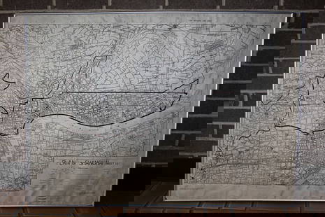
Vandermaelen: Antique Map of Baltic Countires, 1827
Related Maps & Atlases
More Items in Maps & Atlases
View MoreRecommended Transportation & Travel Collectibles
View More


Item Details
Description
TITLE/CONTENT OF MAP: 'Europe - Partie de la Russie - No 9 '
The Baltic countries known today as Estonia, Latvia and Lithuania, the southern part of the Baltic Sea, the Gulf of Finland to Saint Petersburg, part of the east coast of Sweden including Stockholm
DATE PRINTED: 1827
IMAGE SIZE: Approx 71.0 x 52.0cm, 27.75 x 20.25 inches (Large); Please note that this is a folding map.
TYPE: Antique folio-sized lithographic atlas map, hand coloured in outline, on conical projection. This map was published within the first atlas ever to be printed using lithography, and also the first to be printed on a uniform scale
CONDITION: Good; suitable for framing. However, please note: Light spotting.
VERSO: There is nothing printed on the reverse side, which is plain
FOLDING: This is a folding map.
ARTIST/CARTOGRAPHER/ENGRAVER: Philippe Marie Guillaume Vandermaelen. Lithography by Henri Ode
PROVENANCE: "Atlas Universel de Geographie Physique, Politique, Statistique et Mineralogique", dresse par Ph. Vandermaelen - Premiere partie - Europe. Bruxelles. [This landmark atlas is remarkable as the first atlas to have been produced using the then new printing process of lithography. It is also the first atlas to show the whole world in maps using a large uniform scale; in total the 380 conically projected sheets of maps are designed to be joined into a three dimensional terrestrial globe with a diameter of approximately 7.75 metres (25 feet).]
Please note that this lot has a confidential reserve. When you leave a bid in advance of the auction, submit your maximum. The bidder who has submitted the highest bid wins the lot, provided the bid exceeds the reserve price.
Shipping:Domestic: Flat-rate of $24.00 to anywhere within the contiguous U.S. International: Foreign shipping rates are determined by destination. Location: This item ships from United Kingdom
Your purchase is protected:
Photos, descriptions, and estimates were prepared with the utmost care by a fully certified expert and appraiser. All items in this sale are guaranteed authentic.
In the rare event that the item did not conform to the lot description in the sale, Jasper52 specialists are here to help. Buyers may return the item for a full refund provided you notify Jasper52 within 5 days of receiving the item.
The Baltic countries known today as Estonia, Latvia and Lithuania, the southern part of the Baltic Sea, the Gulf of Finland to Saint Petersburg, part of the east coast of Sweden including Stockholm
DATE PRINTED: 1827
IMAGE SIZE: Approx 71.0 x 52.0cm, 27.75 x 20.25 inches (Large); Please note that this is a folding map.
TYPE: Antique folio-sized lithographic atlas map, hand coloured in outline, on conical projection. This map was published within the first atlas ever to be printed using lithography, and also the first to be printed on a uniform scale
CONDITION: Good; suitable for framing. However, please note: Light spotting.
VERSO: There is nothing printed on the reverse side, which is plain
FOLDING: This is a folding map.
ARTIST/CARTOGRAPHER/ENGRAVER: Philippe Marie Guillaume Vandermaelen. Lithography by Henri Ode
PROVENANCE: "Atlas Universel de Geographie Physique, Politique, Statistique et Mineralogique", dresse par Ph. Vandermaelen - Premiere partie - Europe. Bruxelles. [This landmark atlas is remarkable as the first atlas to have been produced using the then new printing process of lithography. It is also the first atlas to show the whole world in maps using a large uniform scale; in total the 380 conically projected sheets of maps are designed to be joined into a three dimensional terrestrial globe with a diameter of approximately 7.75 metres (25 feet).]
Please note that this lot has a confidential reserve. When you leave a bid in advance of the auction, submit your maximum. The bidder who has submitted the highest bid wins the lot, provided the bid exceeds the reserve price.
Shipping:
Your purchase is protected:
Photos, descriptions, and estimates were prepared with the utmost care by a fully certified expert and appraiser. All items in this sale are guaranteed authentic.
In the rare event that the item did not conform to the lot description in the sale, Jasper52 specialists are here to help. Buyers may return the item for a full refund provided you notify Jasper52 within 5 days of receiving the item.
Buyer's Premium
- 15%
Vandermaelen: Antique Map of Baltic Countires, 1827
Estimate $215 - $245
3 bidders are watching this item.
Get approved to bid.
Shipping & Pickup Options
Item located in United KingdomSee Policy for Shipping
Payment
See More Items From This Jasper52 Seller

Auction Curated By

Maps Expert
TOP


![[MAP]. TODESCHI, Pietro. [Nova et Acurata Totius Americae Tabula auct. G.I. Blaeu] America quarta: [MAP]. TODESCHI, Pietro. [Nova et Acurata Totius Americae Tabula auct. G.I. Blaeu] America quarta pars orbis quam plerunq, nuvum orbem appellitant primo detecta est anno 1492 a Christophoro Columbo...](https://p1.liveauctioneers.com/197/329395/177650542_1_x.jpg?height=310&quality=70&version=1715364962)


![[MAPS]. HOMANN, Johann Baptist, HOMANN HEIRS, and Georg Matthäus SEUTTER. [Composite Atlas].: [MAPS]. HOMANN, Johann Baptist (1663-1724), HOMANN HEIRS, and Georg Matthäus SEUTTER (1678-1757). [Composite Atlas]. [Nuremberg, Augsburg, and others: Homann Heirs and others, maps dated between](https://p1.liveauctioneers.com/197/329395/177650530_1_x.jpg?height=310&quality=70&version=1715364962)


![[MAP]. ORTELIUS, Abraham. Turcici Imperii Descriptio.1592.: [MAP]. ORTELIUS, Abraham (1527-1598). Turcici Imperii Descriptio. Antwerp, 1592. Engraved map with hand-coloring. Matted, framed, and double glazed, sight 406 x 521 mm (unexamined out of frame). Decor](https://p1.liveauctioneers.com/197/329395/177650538_1_x.jpg?height=310&quality=70&version=1715364962)
![[MAP]. ORTELIUS, Abraham. Americae Sive Novi Orbis, Nova Descriptio. 1573.: [MAP]. ORTELIUS, Abraham (1527-1598). Americae Sive Novi Orbis, Nova Descriptio. Antwerp, 1573. Engraved map with hand-coloring. Framed and double glazed, visible area 375 x 521 mm (unexamined out of](https://p1.liveauctioneers.com/197/329395/177650534_1_x.jpg?height=310&quality=70&version=1715364962)


