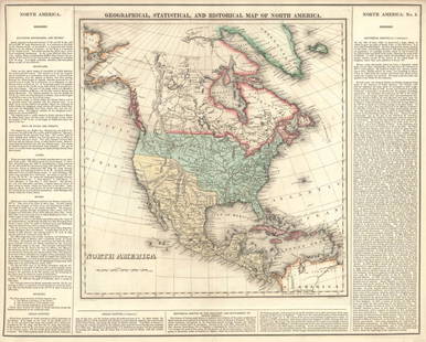
Hondius / Janssonius: Antique Map of North America 1647
Similar Sale History
View More Items in Maps & AtlasesRelated Maps & Atlases
More Items in Maps & Atlases
View MoreRecommended Transportation & Travel Collectibles
View More


Item Details
Description
Captivating map of North America, with California an island, the continent inhabited by numerous vignettes of animals, sailing ships and a few monsters in the oceans.
Burden states that it had a "greater influence than any other to date in perpetuating the theory of California as an island. This was because it was disseminated through the medium of [Hondius'] powerful Dutch publishing house. None of the earlier California as an island maps had reached such a wide audience... Cartographically the map is a careful composition of many different sources and illustrates well the current state of knowledge. The depiction and nomenclature of the west, along with that of the insular California, derive directly from Henry Briggs' The North Part of America, 1635. A legend placed strategically over the north-west coastline offers the opportunity to discontinue a coastline least understood. An unnamed lake still feeds a Rio del Norto flowing incorrectly south-west into what should be the headwaters of the Gulf of California. On the east bank of this river is Real de Nueua Mexico, or Santa Fe…”
This is the second state of the map, the 1647 issue, with imprint of Jan Janssonius in the cartouche at lower left, French text on verso, and signature mark Bbb on the verso.
Johannes Jansson /Jan Janssonius (1588-1664) was a Dutch cartographer and publisher active in the 17th century who lived and worked in Amsterdam.
Please note that this lot has a confidential reserve. When you leave a bid in advance of the auction, submit your maximum. The bidder who has submitted the highest bid wins the lot, provided the bid exceeds the reserve price.
Shipping:
Your purchase is protected:
Photos, descriptions, and estimates were prepared with the utmost care by a fully certified expert and appraiser. All items in this sale are guaranteed authentic.
In the rare event that the item did not conform to the lot description in the sale, Jasper52 specialists are here to help. Buyers may return the item for a full refund provided you notify Jasper52 within 5 days of receiving the item.
Condition
VG+. Tiny pinholes at corners affecting margins only; near fine to fine, coloring bright, a lovely copy.
Buyer's Premium
- 10%
Hondius / Janssonius: Antique Map of North America 1647
Estimate $4,500 - $5,000
23 bidders are watching this item.
Get approved to bid.
Shipping & Pickup Options
Item located in California, USSee Policy for Shipping
Payment
See More Items From This Jasper52 Seller

Auction Curated By

Maps Expert
TOP


![United States of North America, Pacific States by Joseph Wilson Lowry 1860 map: CAPTION PRINTED BELOW PICTURE: The United States of North America, Pacific States [including California, Oregon, Washington, Utah, and part of New Mexico, ] The map shows Washington, Oregon, Utah & Ne](https://p1.liveauctioneers.com/5584/332390/179262935_1_x.jpg?height=310&quality=70&version=1717528223)


![Descrittione… Santa Croce Mondo Nuovo PORCACCHI North America New World 1590 map: CAPTION PRINTED BELOW PICTURE: Descrittione dell' Isola et Terra di Santa Croce, overo Mondo Nuovo [Description of North America or the New World] DATE PRINTED: 1590 IMAGE SIZE: Approx 20.5 x 29.5cm,](https://p1.liveauctioneers.com/5584/332390/179262957_1_x.jpg?height=310&quality=70&version=1717528223)


![Jacob Monk 1853 Map of North America [173506]: Large wall map, typical nvarnish finish, mounted to board for viewing. "New map of that portion of North America exhibiting the United States and Territories, the Canadas, New Brunswick, Nova Scotia,](https://p1.liveauctioneers.com/2699/331495/178785775_1_x.jpg?height=310&quality=70&version=1717094933)

![[MAPS]. HOMANN, Johann Baptist, HOMANN HEIRS, and Georg Matthäus SEUTTER. [Composite Atlas].: [MAPS]. HOMANN, Johann Baptist (1663-1724), HOMANN HEIRS, and Georg Matthäus SEUTTER (1678-1757). [Composite Atlas]. [Nuremberg, Augsburg, and others: Homann Heirs and others, maps dated between](https://p1.liveauctioneers.com/197/329395/177650530_1_x.jpg?height=310&quality=70&version=1715364962)
![[MAP]. TODESCHI, Pietro. [Nova et Acurata Totius Americae Tabula auct. G.I. Blaeu] America quarta: [MAP]. TODESCHI, Pietro. [Nova et Acurata Totius Americae Tabula auct. G.I. Blaeu] America quarta pars orbis quam plerunq, nuvum orbem appellitant primo detecta est anno 1492 a Christophoro Columbo...](https://p1.liveauctioneers.com/197/329395/177650542_1_x.jpg?height=310&quality=70&version=1715364962)
![[MAP]. ORTELIUS, Abraham. Americae Sive Novi Orbis, Nova Descriptio. 1573.: [MAP]. ORTELIUS, Abraham (1527-1598). Americae Sive Novi Orbis, Nova Descriptio. Antwerp, 1573. Engraved map with hand-coloring. Framed and double glazed, visible area 375 x 521 mm (unexamined out of](https://p1.liveauctioneers.com/197/329395/177650534_1_x.jpg?height=310&quality=70&version=1715364962)


![[MAP]. ORTELIUS, Abraham. Turcici Imperii Descriptio.1592.: [MAP]. ORTELIUS, Abraham (1527-1598). Turcici Imperii Descriptio. Antwerp, 1592. Engraved map with hand-coloring. Matted, framed, and double glazed, sight 406 x 521 mm (unexamined out of frame). Decor](https://p1.liveauctioneers.com/197/329395/177650538_1_x.jpg?height=310&quality=70&version=1715364962)
![Set of Twelve Satirical Anthropomorphic Maps of Europe: [SATIRICAL MAPS] A set of twelve satirical anthropomorphic maps of Europe. London: circa 1868. A set of 12 (believed complete) lithographed maps by Vincent Brooks, Day & Son, London, each offering](https://p1.liveauctioneers.com/292/330597/178279264_1_x.jpg?height=310&quality=70&version=1716409282)


![[MAP]. ORTELIUS, Abraham. Romani Imperii Imago. 1592.: [MAP]. ORTELIUS, Abraham (1527-1598). Romani Imperii Imago. Antwerp, 1592. Engraved map with hand-coloring. Matted, framed, and double glazed, visible area 381 x 521 mm (unexamined out of frame). 6 de](https://p1.liveauctioneers.com/197/329395/177650537_1_x.jpg?height=310&quality=70&version=1715364962)
![[MAP]. SPEED, John. A New Mappe of the Romane Empire. 1676.: [MAP]. SPEED, John (ca 1551-1629). A New Mappe of the Romane Empire. London: Basset & Chiswell, 1676. Engraved map with hand-coloring. Framed and double glazed, sight 419 x 559 mm. Decorative cartouch](https://p1.liveauctioneers.com/197/329395/177650541_1_x.jpg?height=310&quality=70&version=1715364962)


