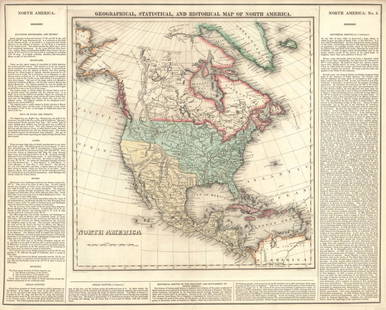
Tallis: Antique Map of North America, 1851
Similar Sale History
View More Items in Maps & AtlasesRelated Maps & Atlases
More Items in North American Maps & Atlases
View MoreRecommended Transportation & Travel Collectibles
View More


Item Details
Description
This is a decorative and striking steel engraved map of North America, featuring Texas with an enlarged panhandle that extends into New Mexico and Colorado. Mexico is still in control of southern Arizona and New Mexico but not of California. Alaska is still shown as Russian America. The map is nicely decorated with vignettes including Beavers, Wapiti Deer, North American Indians, Ancient Monument (Tulum?), Niagara Falls, Convoy of Diamonds, Russian Cossacks, an Eskimo dog sled, and Mount Hekla, Iceland. Color outlines.
John Tallis (1817-1876) was an English cartographic publisher. His company, John Tallis and Company, published views, maps and atlases in London from roughly 1838 to 1851.
Shipping:
Your purchase is protected:
Photos, descriptions, and estimates were prepared with the utmost care by a fully certified expert and appraiser. All items in this sale are guaranteed authentic.
In the rare event that the item did not conform to the lot description in the sale, Jasper52 specialists are here to help. Buyers may return the item for a full refund provided you notify Jasper52 within 5 days of receiving the item.
Condition
Very good. Nice strike and nice hand color of vignettes and outline hand color on map. Age toning mostly in the margins. Marginal soiling. Issued centerfold.
Buyer's Premium
- 10%
Tallis: Antique Map of North America, 1851
Estimate $310 - $350
6 bidders are watching this item.
Get approved to bid.
Shipping & Pickup Options
Item located in Ohio, USSee Policy for Shipping
Payment
See More Items From This Jasper52 Seller

Auction Curated By

Maps Expert
TOP


