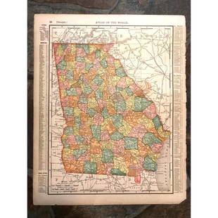
Rand McNally Map of the Dakotas
Similar Sale History
View More Items in Maps & Atlases![1895 Rand McNally Map of New Orleans [verso] Louisiana -- Louisiana [verso] New Orleans: Title: 1895 Rand McNally Map of New Orleans [verso] Louisiana -- Louisiana [verso] New Orleans Cartographer: Rand McNally Year / Place: 1895, Chicago Map Dimension (in.): 12.4 X 9.4 in. This is a high](https://p1.liveauctioneers.com/5584/283091/149355547_1_x.jpg?height=310&quality=70&version=1680038985)
Related Maps & Atlases
More Items in Maps & Atlases
View MoreRecommended Transportation & Travel Collectibles
View More


Item Details
Description
Indexed County and Township Pocket Map and Shippers’ Guide of Dakota. Rand McNally & Co. Lithographed pocket map, with original booklet. Chicago: Rand McNally & Co., 1885. 20 x 14 inches sheet, 36 x 23 1/2 inches framed. This detailed map of Dakota Territory was published in 1885. This fine example features text at the top discusses the ten land districts, schools, railroad grants, US Land Offices and the Sioux Indian Reservation.
Buyer's Premium
- 27%
Rand McNally Map of the Dakotas
Estimate $150 - $250
Get approved to bid.
Shipping & Pickup Options
Item located in New York, NY, usSee Policy for Shipping
Payment

Related Searches
TOP


![Rand McNally: Antique Map of Texas, 1894: Title/Content of Map: 1894 Rand McNally Texas [verso] Indian Territory, N Dakota -- Texas [verso] Indian Territory, North Dakota Date Printed: 1894, Chicago Cartographer: Rand McNally Size: 18.3 x 13.](https://p1.liveauctioneers.com/5584/115725/59466797_1_x.jpg?height=310&quality=70&version=1517366277)


![1898 Rand McNally Map of Texas [verso] Indian Territory and Oklahoma -- Texas [verso] Oklahoma and: Title: 1898 Rand McNally Map of Texas [verso] Indian Territory and Oklahoma -- Texas [verso] Oklahoma and Indian Territory Cartographer: Rand McNally Year / Place: 1898, Chicago Map Dimension (in.): 9](https://p1.liveauctioneers.com/5584/329422/177662173_1_x.jpg?height=310&quality=70&version=1715717898)


![1908 Rand McNally Map of the Panama Canal [verso] Alaska -- Map of the Canal Zone… [verso]: Title: 1908 Rand McNally Map of the Panama Canal [verso] Alaska -- Map of the Canal Zone… [verso] Alaska Cartographer: Rand McNally Year / Place: 1908, Chicago Map Dimension (in.): 6.2 X 4.9 in.](https://p1.liveauctioneers.com/5584/331064/178466470_1_x.jpg?height=310&quality=70&version=1716924723)


![Pittsburg [Sic] Business District Rand, McNally & Co's New Business Atlas Map of Pittsburg. [Sic]: Publication Date: 1911 Title: Pittsburg [Sic] Business District Rand, McNally & Co's New Business Atlas Map of Pittsburg. [Sic] Cartographer: RAND, MCNALLY & CO. Publisher: RAND, MCNALLY & CO. Height:](https://p1.liveauctioneers.com/5584/331064/178466494_1_x.jpg?height=310&quality=70&version=1716924723)


![Map of Southeastern New York.: Publication Date: 1884 Title: Map of Southeastern New York. Cartographer: [RAND, MCNALLY & CO.] Publisher: H.H. HARDESTY & CO. Height: 19.5 Width: 13.3 Double-page map from a scarce Hardesty atlas. In](https://p1.liveauctioneers.com/5584/331064/178466313_1_x.jpg?height=310&quality=70&version=1716924723)
![Map of Western New York.: Publication Date: 1884 Title: Map of Western New York. Cartographer: [RAND, MCNALLY & CO.] Publisher: H.H. HARDESTY & CO. Height: 12.75 Width: 20 Double-page map from a scarce Hardesty atlas. Letterpr](https://p1.liveauctioneers.com/5584/331064/178466481_1_x.jpg?height=310&quality=70&version=1716924723)

![Pittsburg [Sic] and Vicinity.: Publication Date: 1911 Title: Pittsburg [Sic] and Vicinity. Cartographer: RAND, MCNALLY & CO. Publisher: RAND, MCNALLY & CO. Height: 18.25 Width: 12.3 Map showing western Pennsylvania. Shows railroads](https://p1.liveauctioneers.com/5584/331064/178466317_1_x.jpg?height=310&quality=70&version=1716924723)

![[MAP]. TODESCHI, Pietro. [Nova et Acurata Totius Americae Tabula auct. G.I. Blaeu] America quarta: [MAP]. TODESCHI, Pietro. [Nova et Acurata Totius Americae Tabula auct. G.I. Blaeu] America quarta pars orbis quam plerunq, nuvum orbem appellitant primo detecta est anno 1492 a Christophoro Columbo...](https://p1.liveauctioneers.com/197/329395/177650542_1_x.jpg?height=310&quality=70&version=1715364962)


![[MAPS]. HOMANN, Johann Baptist, HOMANN HEIRS, and Georg Matthäus SEUTTER. [Composite Atlas].: [MAPS]. HOMANN, Johann Baptist (1663-1724), HOMANN HEIRS, and Georg Matthäus SEUTTER (1678-1757). [Composite Atlas]. [Nuremberg, Augsburg, and others: Homann Heirs and others, maps dated between](https://p1.liveauctioneers.com/197/329395/177650530_1_x.jpg?height=310&quality=70&version=1715364962)

![[MAP]. ORTELIUS, Abraham. Americae Sive Novi Orbis, Nova Descriptio. 1573.: [MAP]. ORTELIUS, Abraham (1527-1598). Americae Sive Novi Orbis, Nova Descriptio. Antwerp, 1573. Engraved map with hand-coloring. Framed and double glazed, visible area 375 x 521 mm (unexamined out of](https://p1.liveauctioneers.com/197/329395/177650534_1_x.jpg?height=310&quality=70&version=1715364962)
![Set of Twelve Satirical Anthropomorphic Maps of Europe: [SATIRICAL MAPS] A set of twelve satirical anthropomorphic maps of Europe. London: circa 1868. A set of 12 (believed complete) lithographed maps by Vincent Brooks, Day & Son, London, each offering](https://p1.liveauctioneers.com/292/330597/178279264_1_x.jpg?height=310&quality=70&version=1716409282)


![[MAP]. ORTELIUS, Abraham. Turcici Imperii Descriptio.1592.: [MAP]. ORTELIUS, Abraham (1527-1598). Turcici Imperii Descriptio. Antwerp, 1592. Engraved map with hand-coloring. Matted, framed, and double glazed, sight 406 x 521 mm (unexamined out of frame). Decor](https://p1.liveauctioneers.com/197/329395/177650538_1_x.jpg?height=310&quality=70&version=1715364962)


![[FLAGS]. 31-star American parade flag. Ca 1850-1859.: [FLAGS]. 31-star American parade flag. Ca 1850-1859. 22 x 36 1/2 in. cotton flag with 31 printed stars, configured in a double medallion surrounding a much larger central star, that is haloed in both](https://p1.liveauctioneers.com/197/329785/177758218_1_x.jpg?height=310&quality=70&version=1715625218)


