


Incunabulum. A Map of Jerusalem. Hartmann Schedel,
Similar Sale History
View More Items in Maps & Atlases


![1590 Map of Jerusalem from "Civitates Orbis Terrarum" by Hogen & Bran: 1590 Map of Jerusalem from "Civitates Orbis Terrarum" by Hogen & Bran 1p, measuring 21" x 16", [Cologne, Germany], undated [Ca. 1590]. A beautiful color copper etching map of Jerusalem, printed in](https://p1.liveauctioneers.com/6306/250544/130128283_1_x.jpg?height=310&quality=70&version=1654115529)


Related Maps & Atlases


![[NEW YORK CITY – PICTORIAL MAPS]. Group of 3 pictorial maps...: [NEW YORK CITY – PICTORIAL MAPS]. Group of 3 pictorial maps. Including: ANNAND, George (1890—1980). Sinclair Pictorial Map of New York/New York World’s Fair. 26 ¾ x 27 5/8”](https://p1.liveauctioneers.com/928/325952/175495562_1_x.jpg?height=310&quality=70&version=1712935174)
More Items in Maps & Atlases
View More![[Maps] Gio. Ant. Magnini, Italia, 1620: [Maps] Gio. Ant. Magnini, Italia, 1620, Giovanni Antonio Magnini. Italia, data in luce da Fabio suo figliuolo al Serenissimo Ferdinado Gonzaga Duca di Matoua edi Monserrato etc. Bologna, for Sebastian](https://p1.liveauctioneers.com/188/326797/176317457_1_x.jpg?height=310&quality=70&version=1713847031)
![[Maps] Martin Zeiler, Itinerarium Italiae, 1640: [Maps] Martin Zeiler, Itinerarium Italiae, 1640, Martini Zeilleri. Itinerarium Italiae Nov-Antiquae: oder, Raiss-Beschreibung durch Italien, Matthaus Merian, Frankfurt, 40 plates, most double-page, in](https://p1.liveauctioneers.com/188/326797/176317459_1_x.jpg?height=310&quality=70&version=1713847031)


![[MAP]. TODESCHI, Pietro. [Nova et Acurata Totius Americae Tabula auct. G.I. Blaeu] America quarta: [MAP]. TODESCHI, Pietro. [Nova et Acurata Totius Americae Tabula auct. G.I. Blaeu] America quarta pars orbis quam plerunq, nuvum orbem appellitant primo detecta est anno 1492 a Christophoro Columbo...](https://p1.liveauctioneers.com/197/329395/177650542_1_x.jpg?height=310&quality=70&version=1715364962)


Recommended Transportation & Travel Collectibles
View More


Item Details
Description
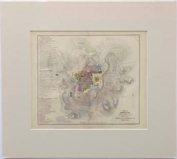
An imaginary map of the walled city of Jerusalem. The Temple surrounded by a round city as it was traditionally depcited in the Middle Ages. By Hartmann Schedel. Nuremberg, 1493. Incunabulum.
A beautiful wooden engraving. Black and white.
From Liber Chronicarum: Das Buch der Croniken und Geschichten [Nuremberg Chronicle], p. xvii, the German edition.Â
Printed only 40 years after the invention of the printing press and a year after the expulsion of Spanish Jewry and Columbus's discovery of America. One of the earliest maps of Jerusalem currently known.Â
Leor, 1123. Rubin, Jerusalem in Maps and Views, page 60.Â
Engraving size: 23x19 cm. Leaf size: 40x28 cm.Â
Buyer's Premium
- 20% up to $100,000.00
- 18% up to $200,000.00
- 15% above $200,000.00
Incunabulum. A Map of Jerusalem. Hartmann Schedel,
Estimate $400 - $800
3 bidders are watching this item.
Shipping & Pickup Options
Item located in Jerusalem, ilSee Policy for Shipping
Payment

Related Searches
TOP