


Bellin: Eastern Canada Map, 1744
Similar Sale History
View More Items in Maps & Atlases


![1869 Mitchell Map of North America [verso] Eastern Canada -- III Map of North America [verso] IV: Title: 1869 Mitchell Map of North America [verso] Eastern Canada -- III Map of North America [verso] IV Dominion of Canada Cartographer: S Mithchell Year / Place: 1869, Philadelphia Map Dimension (in.](https://p1.liveauctioneers.com/5584/293457/155766102_1_x.jpg?height=310&quality=70&version=1687903812)
![MAP, Eastern Canada, Direccion de Hidrografia: Newfoundland & Labrador. Direccion de Hidrografia, [On 2 Sheets] Carta Esferica en dos Hojas del Banco y la Isla de Terranova con Parte de la Costa de Labrador..., 1840 (dated). Black & White. A highl](https://p1.liveauctioneers.com/6576/263260/137251069_1_x.jpg?height=310&quality=70&version=1664399834)


Related Maps & Atlases

![Early French Map of East Coast & Canada [179301]: This is a circa 1790 French map of the Eastern Seaboard of America and parts of Canada. Landmarks and waterways are clearly marked as are the territories inhabited by Indian tribes, including the Iroq](https://p1.liveauctioneers.com/2699/331495/178785745_1_x.jpg?height=310&quality=70&version=1717094933)


More Items in Maps & Atlases
View More![[MAP]. TODESCHI, Pietro. [Nova et Acurata Totius Americae Tabula auct. G.I. Blaeu] America quarta: [MAP]. TODESCHI, Pietro. [Nova et Acurata Totius Americae Tabula auct. G.I. Blaeu] America quarta pars orbis quam plerunq, nuvum orbem appellitant primo detecta est anno 1492 a Christophoro Columbo...](https://p1.liveauctioneers.com/197/329395/177650542_1_x.jpg?height=310&quality=70&version=1715364962)
![[MAPS]. HOMANN, Johann Baptist, HOMANN HEIRS, and Georg Matthäus SEUTTER. [Composite Atlas].: [MAPS]. HOMANN, Johann Baptist (1663-1724), HOMANN HEIRS, and Georg Matthäus SEUTTER (1678-1757). [Composite Atlas]. [Nuremberg, Augsburg, and others: Homann Heirs and others, maps dated between](https://p1.liveauctioneers.com/197/329395/177650530_1_x.jpg?height=310&quality=70&version=1715364962)


![[MAP]. ORTELIUS, Abraham. Americae Sive Novi Orbis, Nova Descriptio. 1573.: [MAP]. ORTELIUS, Abraham (1527-1598). Americae Sive Novi Orbis, Nova Descriptio. Antwerp, 1573. Engraved map with hand-coloring. Framed and double glazed, visible area 375 x 521 mm (unexamined out of](https://p1.liveauctioneers.com/197/329395/177650534_1_x.jpg?height=310&quality=70&version=1715364962)

![Set of Twelve Satirical Anthropomorphic Maps of Europe: [SATIRICAL MAPS] A set of twelve satirical anthropomorphic maps of Europe. London: circa 1868. A set of 12 (believed complete) lithographed maps by Vincent Brooks, Day & Son, London, each offering](https://p1.liveauctioneers.com/292/330597/178279264_1_x.jpg?height=310&quality=70&version=1716409282)


![[MAP]. ORTELIUS, Abraham. Turcici Imperii Descriptio.1592.: [MAP]. ORTELIUS, Abraham (1527-1598). Turcici Imperii Descriptio. Antwerp, 1592. Engraved map with hand-coloring. Matted, framed, and double glazed, sight 406 x 521 mm (unexamined out of frame). Decor](https://p1.liveauctioneers.com/197/329395/177650538_1_x.jpg?height=310&quality=70&version=1715364962)
![[MAP]. ORTELIUS, Abraham. Romani Imperii Imago. 1592.: [MAP]. ORTELIUS, Abraham (1527-1598). Romani Imperii Imago. Antwerp, 1592. Engraved map with hand-coloring. Matted, framed, and double glazed, visible area 381 x 521 mm (unexamined out of frame). 6 de](https://p1.liveauctioneers.com/197/329395/177650537_1_x.jpg?height=310&quality=70&version=1715364962)
![[MAP]. SPEED, John. A New Mappe of the Romane Empire. 1676.: [MAP]. SPEED, John (ca 1551-1629). A New Mappe of the Romane Empire. London: Basset & Chiswell, 1676. Engraved map with hand-coloring. Framed and double glazed, sight 419 x 559 mm. Decorative cartouch](https://p1.liveauctioneers.com/197/329395/177650541_1_x.jpg?height=310&quality=70&version=1715364962)

![[MAP]. ORTELIUS, Abraham. Aevi Veteris, Typus Geographicus. 1601.: [MAP]. ORTELIUS, Abraham (1527-1598). Aevi Veteris, Typus Geographicus. Antwerp, 1601. Engraved map with hand-coloring. Matted, framed, and double glazed, visible area 343 x 470 mm (unexamined out of](https://p1.liveauctioneers.com/197/329395/177650532_1_x.jpg?height=310&quality=70&version=1715364962)
Recommended Transportation & Travel Collectibles
View More


Item Details
Description
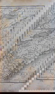
Plan du Port Dauphin et de sa rade avec l'entrée de Labrador, Bellin, Jacques Nicolas. Kershaw, Volume II, entry 517, p. 161: 1st Edition, 1744. Copper engraved map. Image size to neat line: 11-1/4 x 7-7/8 inches. Port Dauphin is now Englishtown on Cape Breton island, Victoria Province, Nova Scotia.
Please note that this lot has a confidential reserve. When you leave a bid in advance of the auction, submit your maximum. Jasper52 will bid on your behalf as much as necessary to ensure that you meet the reserve price or that you remain in the lead, up to your maximum. The bidder who has submitted the highest bid wins the lot, provided the bid exceeds the reserve price.
Shipping:Domestic: Flat-rate of $19.00 to anywhere within the contiguous U.S. International: Foreign shipping rates are determined by destination. Location: This item ships from Canada
Authenticity:
Photos, descriptions, and estimates were prepared with the utmost care by a fully certified expert and appraiser. All items in this sale are guaranteed authentic. Please contact us if there is a misrepresentation so that the item can be returned.
Your purchase is protected:
In the rare event that your purchase from this auction does not meet your expectations, Jasper52 specialists are here to help. If the item did not conform to the lot description in the sale, U.S. buyers may return the item for a full refund provided you notify Jasper52 within 5 days of receiving the item.
Please note that this lot has a confidential reserve. When you leave a bid in advance of the auction, submit your maximum. Jasper52 will bid on your behalf as much as necessary to ensure that you meet the reserve price or that you remain in the lead, up to your maximum. The bidder who has submitted the highest bid wins the lot, provided the bid exceeds the reserve price.
Shipping:
Authenticity:
Photos, descriptions, and estimates were prepared with the utmost care by a fully certified expert and appraiser. All items in this sale are guaranteed authentic. Please contact us if there is a misrepresentation so that the item can be returned.
Your purchase is protected:
In the rare event that your purchase from this auction does not meet your expectations, Jasper52 specialists are here to help. If the item did not conform to the lot description in the sale, U.S. buyers may return the item for a full refund provided you notify Jasper52 within 5 days of receiving the item.
Condition
Was folded now flat. Some loss of paper on the left margin, not affecting the map. Faint image offsetting, otherwise good condition. - See more at: https://www.ldrb.ca/pages/books/7571/jacques-nicolas-bellin/plan-du-port-dauphin-et-de-sa-rade-avec-lentree-de-labrador#sthash.HVnLV65Y.dpuf
Buyer's Premium
- 10%
Bellin: Eastern Canada Map, 1744
Estimate $100 - $150
1 bidder is watching this item.
Get approved to bid.
Shipping & Pickup Options
Item located in Alabama, USSee Policy for Shipping
Payment
Accepts seamless payments through LiveAuctioneers
See More Items From This Jasper52 Seller

Related Searches
TOP