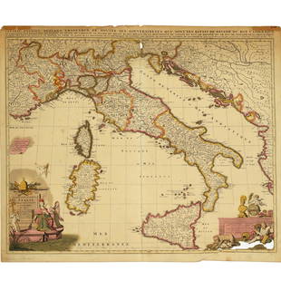
Map Making Explained In Hand Colored Engraving
Similar Sale History
View More Items in Home & DécorRelated Home & Décor
More Items in Home & Décor
View More


Item Details
Description
In this c.1760 hand colored engraving, we can see how maps were made into globes. This print would be a great gift for anyone into maps and technology! It is from a series of engravings executed in Germany during the mid-18th century to illustrate the construction and application of such things as sundials, forts, barometers, columns, telescopes and canons, as well as amplifying and explaining such concepts as perspective, weights and measures, celestial mechanics and mathematics. They are highly informative, beautifully drawn and well colored, and are also very uncommon. The print is matted in acid-free materials and installed in a c.2000 decorative gold frame. The print and matting are in good condition, and the frame may have some minor dings. Print size is 12"x17", and the frame size is 19"x24". Other, similarly framed building & technology prints in my shop are 4152AUC1. 4152AUC2. 4152AUC4, 4152AUC5. 4152AUC6 Item ID: 4152AUC3
Condition
Excellent. See description for eventual details.
Buyer's Premium
- 19%
Map Making Explained In Hand Colored Engraving
Estimate $141 - $188
1 bidder is watching this item.
Shipping & Pickup Options
Item located in New York, NY, usSee Policy for Shipping
Payment

Related Searches
TOP


![Yellow Four O'Clock BASIL BESLER Hand Colored Engraving: Details: BESLER, Basil (1561-1629). [Double-flowered wood anemone] Ranunculus nemorosus flore pleno; [Yellow-wood anemone] Ranunculus nemorosus flore luteo; [Double-flowered bittercress] Nasturtium a](https://p1.liveauctioneers.com/5671/100634/51344504_1_x.jpg?height=310&quality=70&version=1488000481)


![[CUPS AND BALLS]. Bartholomew Fair. Sung by Mr. Matthews, W...: [CUPS AND BALLS]. Bartholomew Fair. Sung by Mr. Matthews, With Unbounded Applause. London: Laurie & Whittle, 1811. Hand-colored etching of a scene from the annual fair with Mr. Punch, clowns, harlequi](https://p1.liveauctioneers.com/928/329228/177514508_1_x.jpg?height=310&quality=70&version=1715272280)


