Caribbean Island Map, by Mount & Page, 1720 (rare &
Similar Sale History


Recommended Items


Item Details
Description
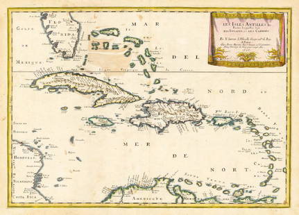
Spectacular sea chart of the Spanish Main to Puerto Rico, from Mount & Page's English Pilot, Fourth Book. Known as the most important English Atlas of Sea Chart covering the Mediterranean and North America during the 18th Century. Map features fine detail of the Windward Islands including Grenada, Saint Vincent, Martinique and Dominica. Dimensions: 18 3/4" x 23"
This item ships from Ocean View, DE.
This item ships from Ocean View, DE.
Condition
Very good, light wear on borders
Buyer's Premium
- 10%
Caribbean Island Map, by Mount & Page, 1720 (rare &
Estimate $1,600 - $2,600
Shipping & Pickup Options
Item located in IL, CA, OH, TX, FL, NY, usSee Policy for Shipping
Payment

Related Searches
TOP


![5 maps: West India Islands, Insulae Danicae...: [Caribbean/Denmark/Central Europe] 5 Maps. Double-page. ++ West India Islands. 3 maps on 1 sheet: St. Christophers, St. Lucia, Nevis. “Engraved by Kirkwood & Son Edinburgh.” in margin. [C. 1810.]](https://p1.liveauctioneers.com/179/117971/60557767_1_x.jpg?height=310&quality=70&version=1520636872)
![Mount & Page: Antique Coast Profile of Ireland, 1749: Title/Content of Map: '[A description of the sea coast of Ireland]' The following places are shown or referred to on the coastal profile chart: Galloway (Galway) Aran Islands Limerick Date Printed: 17](https://p1.liveauctioneers.com/5584/110608/56777156_1_x.jpg?height=310&quality=70&version=1507840413)


![1613 Mercator/Hondius Map of Caribbean Islands -- Cuba: Title/Content of Map: 1613 Mercator/Hondius Map of Caribbean Islands -- Cuba Insula [on sheet with] Hispaniola Insula [and] Insula Iamaica [and] Ins. S. Ioannis [and] Is. Margareta cum Confiniis Date:](https://p1.liveauctioneers.com/5584/144953/73284144_1_x.jpg?height=310&quality=70&version=1562102885)


![Descrittione dell' Isola di Cuba. PORCACCHI. Jamaica Hispaniola 1620 old map: TITLE/CONTENT OF MAP: Descrittione dell' Isola di Cuba [Description of the island of Cuba] The map depicts the Caribbean island of Cuba. The map is orientated towards the north. DATE PRINTED: 1620 IMA](https://p1.liveauctioneers.com/5584/327764/176591154_1_x.jpg?height=310&quality=70&version=1714507756)
![Descrittione dell' Isola Iamaica…. PORCACCHI. Jamaica 1590 old antique map: CAPTION PRINTED BELOW PICTURE: Descrittione dell' Isola Iamaica, hora detta si S. Iacopo [Description of the island of Jamaica, now called St. Jacob's island] The map depicts the Caribbean island of J](https://p1.liveauctioneers.com/5584/327764/176591064_1_x.jpg?height=310&quality=70&version=1714507756)
![Descrittione dell' Isola di Cuba. PORCACCHI. Jamaica Hispaniola 1590 old map: CAPTION PRINTED BELOW PICTURE: Descrittione dell' Isola di Cuba [Description of the island of Cuba] The map depicts the Caribbean island of Cuba. The map is orientated towards the north. DATE PRINTED:](https://p1.liveauctioneers.com/5584/327764/176590845_1_x.jpg?height=310&quality=70&version=1714507756)
