


Authentic 1865 map of Maine, Johnson/Ward
Similar Sale History
View More Items in Maps & Atlases

![MAPS - Maine. U.S. Gov.: Maine. U.S. Gov., [Lot of 2] Map of the Northern Part of the State of Maine and of the Adjacent British Provinces... [and] Extract from a Map of the British and French Dominions in North America, 1838](https://p1.liveauctioneers.com/6576/142214/71976779_1_x.jpg?height=310&quality=70&version=1557929467)
![[MANUSCRIPT MAP-MAINE] CHADWICK, JOSEPH. Plan of part of the lands belonging to the Heirs of Brigd.r: [MANUSCRIPT MAP-MAINE] CHADWICK, JOSEPH. Plan of part of the lands belonging to the Heirs of Brigd.r Waldo ... measured by Joseph Chadwick Nov.r 1765. [New England]: November, 1765. Manuscript survey](https://p1.liveauctioneers.com/292/250642/130213647_1_x.jpg?height=310&quality=70&version=1654271664)


Related Maps & Atlases


![Maine Map, 1840 [181582]: 1840 Maine map by N. Curriers Litho, NY. Mounted to sheet music. 8.5x8.5". Maine](https://p1.liveauctioneers.com/2699/331495/178785758_1_x.jpg?height=310&quality=70&version=1717094933)


![Maine: Publication Date: 1884 Title: Maine Cartographer: [RAND, MCNALLY & CO.] Publisher: H.H. HARDESTY & CO. Height: 19.1 Width: 13 Double-page map from a scarce Hardesty atlas. Quite detailed. Shows and na](https://p1.liveauctioneers.com/5584/331064/178466395_1_x.jpg?height=310&quality=70&version=1716924723)

![French Map of America Southeast [179304]: Northeastern American map published 1788 from a French cartographer. Map measures 9"x 13". Published during America's War of Independence from Great Britain (1176-1783), this map features the mid-Atla](https://p1.liveauctioneers.com/2699/331495/178785746_1_x.jpg?height=310&quality=70&version=1717094933)
![SCOTLAND (4 Maps):: SCOTLAND (4 Maps): Collins, Captain Greenvile: The East Coast of Scotland with the Isles of Orkney and Shetland. c.1693, hand-coloured and mounted. 48 x 56cm; [The Firth of Murry] - To the Rt. Honorab](https://p1.liveauctioneers.com/1782/331487/178781748_1_x.jpg?height=310&quality=70&version=1716992745)


More Items in Maps & Atlases
View More
![[MAP]. TODESCHI, Pietro. [Nova et Acurata Totius Americae Tabula auct. G.I. Blaeu] America quarta: [MAP]. TODESCHI, Pietro. [Nova et Acurata Totius Americae Tabula auct. G.I. Blaeu] America quarta pars orbis quam plerunq, nuvum orbem appellitant primo detecta est anno 1492 a Christophoro Columbo...](https://p1.liveauctioneers.com/197/329395/177650542_1_x.jpg?height=310&quality=70&version=1715364962)

![[MAPS]. HOMANN, Johann Baptist, HOMANN HEIRS, and Georg Matthäus SEUTTER. [Composite Atlas].: [MAPS]. HOMANN, Johann Baptist (1663-1724), HOMANN HEIRS, and Georg Matthäus SEUTTER (1678-1757). [Composite Atlas]. [Nuremberg, Augsburg, and others: Homann Heirs and others, maps dated between](https://p1.liveauctioneers.com/197/329395/177650530_1_x.jpg?height=310&quality=70&version=1715364962)

![[MAP]. ORTELIUS, Abraham. Americae Sive Novi Orbis, Nova Descriptio. 1573.: [MAP]. ORTELIUS, Abraham (1527-1598). Americae Sive Novi Orbis, Nova Descriptio. Antwerp, 1573. Engraved map with hand-coloring. Framed and double glazed, visible area 375 x 521 mm (unexamined out of](https://p1.liveauctioneers.com/197/329395/177650534_1_x.jpg?height=310&quality=70&version=1715364962)
![Set of Twelve Satirical Anthropomorphic Maps of Europe: [SATIRICAL MAPS] A set of twelve satirical anthropomorphic maps of Europe. London: circa 1868. A set of 12 (believed complete) lithographed maps by Vincent Brooks, Day & Son, London, each offering](https://p1.liveauctioneers.com/292/330597/178279264_1_x.jpg?height=310&quality=70&version=1716409282)


![[MAP]. ORTELIUS, Abraham. Turcici Imperii Descriptio.1592.: [MAP]. ORTELIUS, Abraham (1527-1598). Turcici Imperii Descriptio. Antwerp, 1592. Engraved map with hand-coloring. Matted, framed, and double glazed, sight 406 x 521 mm (unexamined out of frame). Decor](https://p1.liveauctioneers.com/197/329395/177650538_1_x.jpg?height=310&quality=70&version=1715364962)
![[MAP]. ORTELIUS, Abraham. Romani Imperii Imago. 1592.: [MAP]. ORTELIUS, Abraham (1527-1598). Romani Imperii Imago. Antwerp, 1592. Engraved map with hand-coloring. Matted, framed, and double glazed, visible area 381 x 521 mm (unexamined out of frame). 6 de](https://p1.liveauctioneers.com/197/329395/177650537_1_x.jpg?height=310&quality=70&version=1715364962)
![[MAP]. SPEED, John. A New Mappe of the Romane Empire. 1676.: [MAP]. SPEED, John (ca 1551-1629). A New Mappe of the Romane Empire. London: Basset & Chiswell, 1676. Engraved map with hand-coloring. Framed and double glazed, sight 419 x 559 mm. Decorative cartouch](https://p1.liveauctioneers.com/197/329395/177650541_1_x.jpg?height=310&quality=70&version=1715364962)
Recommended Transportation & Travel Collectibles
View More

![[FLAGS]. 31-star American parade flag. Ca 1850-1859.: [FLAGS]. 31-star American parade flag. Ca 1850-1859. 22 x 36 1/2 in. cotton flag with 31 printed stars, configured in a double medallion surrounding a much larger central star, that is haloed in both](https://p1.liveauctioneers.com/197/329785/177758218_1_x.jpg?height=310&quality=70&version=1715625218)


Item Details
Description
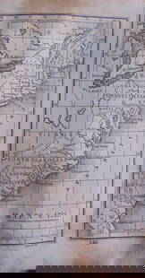
Johnson’s Maine published 1865 by the firm of Johnson and Ward. Vintage hand colored map of Maine. Includes markings for railroads, common roads, and canals, with a reference for explanation. Shows some topographical detail. Shows early boundary in the northwest part of the state. Three small sulfide spots and general toning to edges. 12.75 x 15.75
Reserve: $65.00
Shipping:Domestic: Flat-rate of $8.00 to anywhere within the contiguous U.S. International: Foreign shipping rates are determined by destination. International shipping may be subject to VAT. Combined shipping: Please ask about combined shipping for multiple lots before bidding. Location: This item ships from Ohio.
Your purchase is protected:
Photos, descriptions, and estimates were prepared with the utmost care by a fully certified expert and appraiser. All items in this sale are guaranteed authentic.
In the rare event that the item did not conform to the lot description in the sale, Jasper52 specialists are here to help. Buyers may return the item for a full refund provided you notify Jasper52 within 5 days of receiving the item.
Reserve: $65.00
Shipping:
Your purchase is protected:
Photos, descriptions, and estimates were prepared with the utmost care by a fully certified expert and appraiser. All items in this sale are guaranteed authentic.
In the rare event that the item did not conform to the lot description in the sale, Jasper52 specialists are here to help. Buyers may return the item for a full refund provided you notify Jasper52 within 5 days of receiving the item.
Condition
Very good
Buyer's Premium
- 15%
Authentic 1865 map of Maine, Johnson/Ward
Estimate $100 - $130
2 bidders are watching this item.
Get approved to bid.
Shipping & Pickup Options
Item located in Ohio, US$8 shipping in the US
Payment
Accepts seamless payments through LiveAuctioneers
See More Items From This Jasper52 Seller

Related Searches
TOP