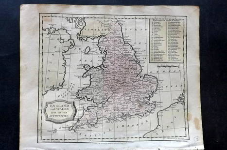
Carel Allard, Map of England & Wales, 18th Century
Similar Sale History
View More Items in Maps & AtlasesRelated Maps & Atlases
More Items in Maps & Atlases
View MoreRecommended Transportation & Travel Collectibles
View More


Item Details
Description
Description: A ca. 1740 map of England (Regni Angliae Wallae Principatus Tabula) by Carel Allard, published by Covens & Mortier.
Type: Map
Materials: Paper
Markings & Inscriptions: Marked
Date: Ca. 1740
Maker: Carel Allard
Dimensions: 20.75"x 24.75"
Provenance: From a Glenside, Pennsylvania collection.
Type: Map
Materials: Paper
Markings & Inscriptions: Marked
Date: Ca. 1740
Maker: Carel Allard
Dimensions: 20.75"x 24.75"
Provenance: From a Glenside, Pennsylvania collection.
Condition
Fair condition, with moderate to advanced toning, scattered foxing, edgewear including small tears, and a central crease.
Buyer's Premium
- 25%
Carel Allard, Map of England & Wales, 18th Century
Estimate $100 - $200
1 bidder is watching this item.
Shipping & Pickup Options
Item located in West Chester, PA, usSee Policy for Shipping
Local Pickup Available
Payment
Accepts seamless payments through LiveAuctioneers

Related Searches
TOP


![[MAP]. TODESCHI, Pietro. [Nova et Acurata Totius Americae Tabula auct. G.I. Blaeu] America quarta: [MAP]. TODESCHI, Pietro. [Nova et Acurata Totius Americae Tabula auct. G.I. Blaeu] America quarta pars orbis quam plerunq, nuvum orbem appellitant primo detecta est anno 1492 a Christophoro Columbo...](https://p1.liveauctioneers.com/197/329395/177650542_1_x.jpg?height=310&quality=70&version=1715364962)


![[MAPS]. HOMANN, Johann Baptist, HOMANN HEIRS, and Georg Matthäus SEUTTER. [Composite Atlas].: [MAPS]. HOMANN, Johann Baptist (1663-1724), HOMANN HEIRS, and Georg Matthäus SEUTTER (1678-1757). [Composite Atlas]. [Nuremberg, Augsburg, and others: Homann Heirs and others, maps dated between](https://p1.liveauctioneers.com/197/329395/177650530_1_x.jpg?height=310&quality=70&version=1715364962)


