


Ratzer, Plan of the City of New York, Second State
Similar Sale History
View More Items in Maps & Atlases
![(3pc) MAPS OF NEW YORK: JOHN MONTRESOR: Including; "A Plan of the City of New York & Its Environs to Greenwich", for D.T. Valentine's Manual 1855; Bernard Ratzer,[29-3/4 x 23-3/4 in, framed]; "Plan of the City of New York in North America S](https://p1.liveauctioneers.com/522/173495/87372920_1_x.jpg?height=310&quality=70&version=1594330064)


Related Maps & Atlases


![1902 Cram Map of New York City [verso] Washington DC [verso] Baltimore -- New York [verso]: Title: 1902 Cram Map of New York City [verso] Washington DC [verso] Baltimore -- New York [verso] Washington] and [verso] Baltimore Cartographer: G Cram Year / Place: 1902, Chicago Map Dimension (in.)](https://p1.liveauctioneers.com/5584/331064/178466310_1_x.jpg?height=310&quality=70&version=1716924723)


![Map of Southeastern New York.: Publication Date: 1884 Title: Map of Southeastern New York. Cartographer: [RAND, MCNALLY & CO.] Publisher: H.H. HARDESTY & CO. Height: 19.5 Width: 13.3 Double-page map from a scarce Hardesty atlas. In](https://p1.liveauctioneers.com/5584/331064/178466313_1_x.jpg?height=310&quality=70&version=1716924723)
More Items in Maps & Atlases
View More![[MAPS]. HOMANN, Johann Baptist, HOMANN HEIRS, and Georg Matthäus SEUTTER. [Composite Atlas].: [MAPS]. HOMANN, Johann Baptist (1663-1724), HOMANN HEIRS, and Georg Matthäus SEUTTER (1678-1757). [Composite Atlas]. [Nuremberg, Augsburg, and others: Homann Heirs and others, maps dated between](https://p1.liveauctioneers.com/197/329395/177650530_1_x.jpg?height=310&quality=70&version=1715364962)
![[MAP]. TODESCHI, Pietro. [Nova et Acurata Totius Americae Tabula auct. G.I. Blaeu] America quarta: [MAP]. TODESCHI, Pietro. [Nova et Acurata Totius Americae Tabula auct. G.I. Blaeu] America quarta pars orbis quam plerunq, nuvum orbem appellitant primo detecta est anno 1492 a Christophoro Columbo...](https://p1.liveauctioneers.com/197/329395/177650542_1_x.jpg?height=310&quality=70&version=1715364962)

![[MAP]. ORTELIUS, Abraham. Americae Sive Novi Orbis, Nova Descriptio. 1573.: [MAP]. ORTELIUS, Abraham (1527-1598). Americae Sive Novi Orbis, Nova Descriptio. Antwerp, 1573. Engraved map with hand-coloring. Framed and double glazed, visible area 375 x 521 mm (unexamined out of](https://p1.liveauctioneers.com/197/329395/177650534_1_x.jpg?height=310&quality=70&version=1715364962)


![Set of Twelve Satirical Anthropomorphic Maps of Europe: [SATIRICAL MAPS] A set of twelve satirical anthropomorphic maps of Europe. London: circa 1868. A set of 12 (believed complete) lithographed maps by Vincent Brooks, Day & Son, London, each offering](https://p1.liveauctioneers.com/292/330597/178279264_1_x.jpg?height=310&quality=70&version=1716409282)


![[MAP]. ORTELIUS, Abraham. Turcici Imperii Descriptio.1592.: [MAP]. ORTELIUS, Abraham (1527-1598). Turcici Imperii Descriptio. Antwerp, 1592. Engraved map with hand-coloring. Matted, framed, and double glazed, sight 406 x 521 mm (unexamined out of frame). Decor](https://p1.liveauctioneers.com/197/329395/177650538_1_x.jpg?height=310&quality=70&version=1715364962)
![[MAP]. SPEED, John. A New Mappe of the Romane Empire. 1676.: [MAP]. SPEED, John (ca 1551-1629). A New Mappe of the Romane Empire. London: Basset & Chiswell, 1676. Engraved map with hand-coloring. Framed and double glazed, sight 419 x 559 mm. Decorative cartouch](https://p1.liveauctioneers.com/197/329395/177650541_1_x.jpg?height=310&quality=70&version=1715364962)
![[MAP]. ORTELIUS, Abraham. Aevi Veteris, Typus Geographicus. 1601.: [MAP]. ORTELIUS, Abraham (1527-1598). Aevi Veteris, Typus Geographicus. Antwerp, 1601. Engraved map with hand-coloring. Matted, framed, and double glazed, visible area 343 x 470 mm (unexamined out of](https://p1.liveauctioneers.com/197/329395/177650532_1_x.jpg?height=310&quality=70&version=1715364962)


Recommended Transportation & Travel Collectibles
View More


Item Details
Description
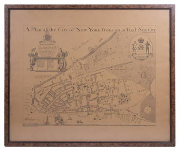
RATZER, BERNARD (fl. 1756-1777).
Plan of the City of New York in North America, surveyed in the years 1766 & 1767.
Engraved folding map dissected into sixteen panels, backed on linen, with board covers.
London: Faden & Jeffreys, 1776. Second State (imprint of Faden & Jeffreys above the view).
48 5/8" x 35 3/4" inches sheet, 54 1/2” x 42” framed.
Comparable: Christie's, 2022 - $625,000; Doyle, 2021 - $151,200.
"Perhaps the finest map of an American city and its environs produced in the eighteenth century. In its final form, its geographic precision combined with highly artistic engraving was unsurpassed in the urban cartography of its day ... The Ratzer Map evokes a halcyon period in the history of Manhattan (Manhattan in Maps, p. 73).
Born of revolution, Bernard Ratzer's famous plan was based on surveys ordered by New York's Royal Governor, Sir Henry Moore, in response to the Stamp Act Riots of 1765. Moore and his military advisors were concerned that New York would become a center of violence by colonialists, and they needed a far more accurate map of the city than was then available. Ratzer, a British Army engineer, was chosen to perform the necessary survey and to draw the resulting map.
Ratzer completed his initial survey and drew the first of his plans of the City in 1766. This plan focused on the Southern part of Manhattan up to about modern 50th Street. When it was published his name was misspelled, and this initial effort is commonly referred to today as the "Ratzen Plan." The work was magnificent, a quantum improvement in detail over previous maps of the city, but even more detail and most of all a broader scope was sought by the British governmental and military officials who ordered the map.
In 1767, Ratzer began a more comprehensive survey of the areas surrounding the city. The resulting plan was issued in 1770. Commonly referred to as the "Ratzer Map." it is one of the most remarkable maps ever produced, and certainly among the most artistic urban maps of its day. Its level of detail was unprecedented, extending not only to the island's physical topography but including buildings, wharves, roadways, farms and homes. Important landowners are identified on the map, their estates covering much of upper Manhattan. Details of nearby Brooklyn and New Jersey helped meet the military's needs for vital information about those sites of battle information that became critical during the several attempts at pincer movements against Washington and his troops once war broke out. At the bottom of the map Ratzer included a magnificent "South West View of the City of New York from Governor's Island." Drawn by Lt. Thomas Davies, this view was a striking decorative element, but more it would serve as a valuable aid to those approaching from or anchored in the harbor.
Only a handful of examples of the 1770 issue are known, but in 1776 as war appeared increasingly likely, the map was republished by the London firm of Faden & Jeffreys. Numerous examples accompanied the British army and navy to the colonies. As the most detailed and topographically accurate map available, this issue was used extensively by British officers. in the field throughout the American Revolution. Examples like this one, which has been dissected and mounted on linen to be folded into a protective cover, were likely used in such a fashion. A similar example, replete with notes by the British army general Hugh Percy, is in the collection of the Brooklyn Historical Society.
A fine example of one of the most important and fascinating maps in American history.
Stokes, Iconography ("one of the most beautiful, important and accurate plans of New York."), p. 341; Schwartz/Ehrenberg The Mapping of America, p. 192; Cohen/Augustyn Manhattan in Maps p. 73. Cohen & Brown, Revolution: Mapping the Road to American Independence; Cumming, "The Montresor-Ratzer-Sauthier Sequence of Maps of New York City, 1766-76" in Imago Mundi 31, pages 55-65, map 9(b); Pritchard & Taliaferro, Degrees of Latitude, 46. [6.1S].
Buyer's Premium
- 25%
Ratzer, Plan of the City of New York, Second State
Estimate $200,000 - $250,000
3 bidders are watching this item.
Get approved to bid.
Shipping & Pickup Options
Item located in New York, NY, usOffers In-House Shipping
Local Pickup Available
Payment
Accepts seamless payments through LiveAuctioneers

TOP