


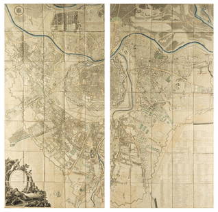
Rocque (John) A Plan of Geneva and the Environs - Plan de Geneve avec ses Environs, engraved map, 17
Similar Sale History
View More Items in Maps & Atlases![Carte de Bombay et de ses environs'. Mumbai India Thane: TITLE/CONTENT OF MAP: 'Plan de Bombay et de ses environs tiré de Thornton Hyd. Ang [Map of Mumbai and its environs]' DATE PRINTED: 1751 IMAGE SIZE: Approx 20.5 x 27.5cm, 8 x 10.75 inches (Medium); Pl](https://p1.liveauctioneers.com/5584/144578/73088416_1_x.jpg?height=310&quality=70&version=1561513819)


![(3pc) MAPS OF NEW YORK: JOHN MONTRESOR: Including; "A Plan of the City of New York & Its Environs to Greenwich", for D.T. Valentine's Manual 1855; Bernard Ratzer,[29-3/4 x 23-3/4 in, framed]; "Plan of the City of New York in North America S](https://p1.liveauctioneers.com/522/173495/87372920_1_x.jpg?height=310&quality=70&version=1594330064)


Related Maps & Atlases

![Détroit de Magellan. Strait of Magellan. Chile. BONNE 1790 old antique map: TITLE/CONTENT OF MAP: [Voyage des Capitaines Byron, Vallis et Carteret] Détroit de Magellan avec les Plans des principaux Ports, Bayes &c. de ce Détroit // Havre Swalow ou de l'Hirondelle //](https://p1.liveauctioneers.com/5584/330116/177980527_1_x.jpg?height=310&quality=70&version=1716324705)
![Détroit de Magellan. Strait of Magellan. Chile. BONNE 1788 old antique map: TITLE/CONTENT OF MAP: [Voyage des Capitaines Byron, Vallis et Carteret] Détroit de Magellan avec les Plans des principaux Ports, Bayes &c. de ce Détroit // Havre Swalow ou de l'Hirondelle //](https://p1.liveauctioneers.com/5584/330116/177980442_1_x.jpg?height=310&quality=70&version=1716324705)
![1705 Map LE COMBAT DE STEENKERKE [Battle of Steenkerque] by Nicolas de Fer: 1705 Copperplate Engraved Military Plan / Map Entitled LE COMBAT DE STEENKERKE [Battle of Steenkerque] by Nicolas de Fer - 3 August 1692 (the text gives a date of 5 August 1692) | Approx. Size: 10.5"](https://p1.liveauctioneers.com/6084/330420/178181962_1_x.jpg?height=310&quality=70&version=1716391551)


More Items in Maps & Atlases
View More


![[MAP]. TODESCHI, Pietro. [Nova et Acurata Totius Americae Tabula auct. G.I. Blaeu] America quarta: [MAP]. TODESCHI, Pietro. [Nova et Acurata Totius Americae Tabula auct. G.I. Blaeu] America quarta pars orbis quam plerunq, nuvum orbem appellitant primo detecta est anno 1492 a Christophoro Columbo...](https://p1.liveauctioneers.com/197/329395/177650542_1_x.jpg?height=310&quality=70&version=1715364962)

![[MAPS]. HOMANN, Johann Baptist, HOMANN HEIRS, and Georg Matthäus SEUTTER. [Composite Atlas].: [MAPS]. HOMANN, Johann Baptist (1663-1724), HOMANN HEIRS, and Georg Matthäus SEUTTER (1678-1757). [Composite Atlas]. [Nuremberg, Augsburg, and others: Homann Heirs and others, maps dated between](https://p1.liveauctioneers.com/197/329395/177650530_1_x.jpg?height=310&quality=70&version=1715364962)


![[MAP]. ORTELIUS, Abraham. Americae Sive Novi Orbis, Nova Descriptio. 1573.: [MAP]. ORTELIUS, Abraham (1527-1598). Americae Sive Novi Orbis, Nova Descriptio. Antwerp, 1573. Engraved map with hand-coloring. Framed and double glazed, visible area 375 x 521 mm (unexamined out of](https://p1.liveauctioneers.com/197/329395/177650534_1_x.jpg?height=310&quality=70&version=1715364962)


![[MAP]. ORTELIUS, Abraham. Turcici Imperii Descriptio.1592.: [MAP]. ORTELIUS, Abraham (1527-1598). Turcici Imperii Descriptio. Antwerp, 1592. Engraved map with hand-coloring. Matted, framed, and double glazed, sight 406 x 521 mm (unexamined out of frame). Decor](https://p1.liveauctioneers.com/197/329395/177650538_1_x.jpg?height=310&quality=70&version=1715364962)

![[MAP]. ORTELIUS, Abraham. Aevi Veteris, Typus Geographicus. 1601.: [MAP]. ORTELIUS, Abraham (1527-1598). Aevi Veteris, Typus Geographicus. Antwerp, 1601. Engraved map with hand-coloring. Matted, framed, and double glazed, visible area 343 x 470 mm (unexamined out of](https://p1.liveauctioneers.com/197/329395/177650532_1_x.jpg?height=310&quality=70&version=1715364962)
Recommended Transportation & Travel Collectibles
View More


![[FLAGS]. 31-star American parade flag. Ca 1850-1859.: [FLAGS]. 31-star American parade flag. Ca 1850-1859. 22 x 36 1/2 in. cotton flag with 31 printed stars, configured in a double medallion surrounding a much larger central star, that is haloed in both](https://p1.liveauctioneers.com/197/329785/177758218_1_x.jpg?height=310&quality=70&version=1715625218)


Item Details
Description
Rocque (John) A Plan of Geneva and the Environs - Plan de Geneve avec ses Environs, detailed plan with 3 inset maps, including a plan of ancient Geneva alongside Lac Leman, another regional map of the environs of the Geneva, and a further inset plan showing the city fortifications as of 1715, engraved map with fine hand-colouring, on cream laid paper without watermark, platemark 500 x 655 mm (19 3/4 x 25 3/4 in), sheet 535 x 710 mm (21 x 28 in), central vertical fold as issued, 1766
⁂ Scarce at auction.
⁂ Scarce at auction.
Buyer's Premium
- 26% up to £20,000.00
- 25% up to £500,000.00
- 20% above £500,000.00
Rocque (John) A Plan of Geneva and the Environs - Plan de Geneve avec ses Environs, engraved map, 17
Estimate £400 - £600
3 bidders are watching this item.
Shipping & Pickup Options
Item located in London, London, ukOffers In-House Shipping
Local Pickup Available
Payment

Auction Curated By

International Head of Books and Works on Paper

Modern First Editions and 20th Century Literature
TOP