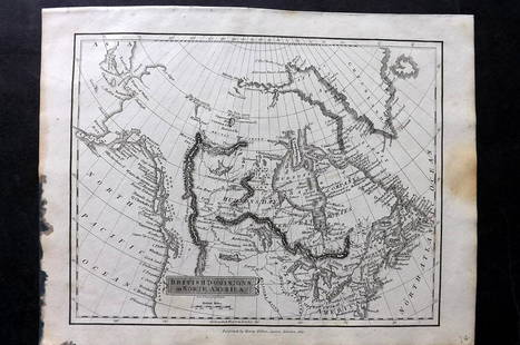
[CANADIAN ANTIQUE MAP] BRITISH AMERICA. C.1850
Similar Sale History
View More Items in Maps & Atlases

![[CANADIAN ANTIQUE MAP] FIFTH & SIXTH WARDS, CITY OF HAMILTON. COLOURED. C. 1870S: [CANADIAN ANTIQUE MAP] COLOURED ANTIQUE MAP OF FIFTH & SIXTH WARDS, CITY OF HAMILTON. Printed circa 1870s.Image size (approx): 15.1/2"x25.3/4" Original antique map of Fifth & Sixth Wards of the City](https://p1.liveauctioneers.com/8321/286473/155233340_1_x.jpg?height=310&quality=70&version=1686787412)
Related Maps & Atlases
More Items in Maps & Atlases
View MoreRecommended Transportation & Travel Collectibles
View More


![[CANADIAN ANTIQUE MAP] BRITISH AMERICA. C.1850](https://p1.liveauctioneers.com/8321/286473/155235081_1_x.jpg?quality=1&version=1686868575&width=486)
![[CANADIAN ANTIQUE MAP] BRITISH AMERICA. C.1850](https://p1.liveauctioneers.com/8321/286473/155235081_1_x.jpg?quality=80&version=1686868575)
Item Details
Description
[CANADIAN ANTIQUE MAP] BRITISH AMERICA. Hand-coloured.Circa 1850sPublished by John Tallis, London and NY, 1850Frame size: (approx) 17.1/2"x21.1/2"Original Tallis map of British America (now Canada). Vertical folding lines in the middle showing some darkening, slightly age toned. This map hasn't been examined under glass. NOTE: This map is framed, if we have to ship it, it would be removed from the frame and shipped in a tube; local pick up is encouraged.
Buyer's Premium
- 20% up to CA$10,000.00
- 15% up to CA$50,000.00
- 10% above CA$50,000.00
[CANADIAN ANTIQUE MAP] BRITISH AMERICA. C.1850
Estimate CA$200 - CA$400
2 bidders are watching this item.
Shipping & Pickup Options
Item located in Toronto, Ontario, caOffers In-House Shipping
Local Pickup Available
Payment

Related Searches
TOP


![[ANTIQUE MAPS] TALLIS--BRITISH AMERICA C.1849: [ANTIQUE MAPS] TALLIS, John "BRITISH AMERICA" John Tallis, Circa 1849. Approx. 33X23cm. Decorative borders and illustrated vignettes, including a city view of Boston. Frame not included. Map will be r](https://p1.liveauctioneers.com/8321/253807/131946543_1_x.jpg?height=310&quality=70&version=1657215695)


![[CANADIAN ANTIQUE MAP] CITY [PLAN] OF QUEBEC. 1830: [CANADIAN ANTIQUE MAP] CITY [PLAN] OF QUEBEC.Engraved by J.&.C. Walker.Image size (approx): 7.1/2"x9.1/4" Original engraved map, circa 1830s. Original antique map city plan, of The City of Montreal. S](https://p1.liveauctioneers.com/8321/286473/155233365_1_x.jpg?height=310&quality=70&version=1686787412)


![d'Anville (Jean Baptiste Bourguignon) [Untitled Composite Atlas with 102 map sheets], [probably: d'Anville (Jean Baptiste Bourguignon) [Untitled Composite Atlas with 102 map sheets], comprising 20 double-page maps, 9 two-sheet double-page maps, 3 two-sheet maps on folding double-pages [Asia, Afri](https://p1.liveauctioneers.com/5458/329231/177514974_1_x.jpg?height=310&quality=70&version=1715269091)


![South-west Europe. Swiss Savoy. British Hanover. THOMSON 1817 old antique map: TITLE/CONTENT OF MAP: [South-west sheet of] A map of Europe, with the political divisions after the Peace of Paris and Congress of Vienna The map shows south west Europe after the Congress of Vienna.](https://p1.liveauctioneers.com/5584/328641/177014448_1_x.jpg?height=310&quality=70&version=1715113718)


![[Maps] Martin Zeiler, Itinerarium Italiae, 1640: [Maps] Martin Zeiler, Itinerarium Italiae, 1640, Martini Zeilleri. Itinerarium Italiae Nov-Antiquae: oder, Raiss-Beschreibung durch Italien, Matthaus Merian, Frankfurt, 40 plates, most double-page, in](https://p1.liveauctioneers.com/188/326797/176317459_1_x.jpg?height=310&quality=70&version=1713847031)
![[Maps] Gio. Ant. Magnini, Italia, 1620: [Maps] Gio. Ant. Magnini, Italia, 1620, Giovanni Antonio Magnini. Italia, data in luce da Fabio suo figliuolo al Serenissimo Ferdinado Gonzaga Duca di Matoua edi Monserrato etc. Bologna, for Sebastian](https://p1.liveauctioneers.com/188/326797/176317457_1_x.jpg?height=310&quality=70&version=1713847031)


![[MAP]. TODESCHI, Pietro. [Nova et Acurata Totius Americae Tabula auct. G.I. Blaeu] America quarta: [MAP]. TODESCHI, Pietro. [Nova et Acurata Totius Americae Tabula auct. G.I. Blaeu] America quarta pars orbis quam plerunq, nuvum orbem appellitant primo detecta est anno 1492 a Christophoro Columbo...](https://p1.liveauctioneers.com/197/329395/177650542_1_x.jpg?height=310&quality=70&version=1715364962)


