MAP, Wales, Blaeu
Similar Sale History
View More Items in Maps & AtlasesRelated Maps & Atlases
More Items in Maps & Atlases
View MoreRecommended Transportation & Travel Collectibles
View More


Item Details
Description
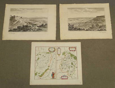
Northwestern Wales. Blaeu Family, Comitatus Caernarvoniensis; Vernacule Carnarvon-Shire et Mona Insula Vulgo Anglesey, from Le Theatre du Monde ou Nouvel Atlas, 1645 (circa). Black & White. A handsome map of Caernarvonshire and Anglesey with present-day Gwynedd and Mon. The decorative title and scale cartouche features a farmer with his harvest, which symbolizes Caernarfon as the place of investiture to the Princes. The map is further embellished with the Royal Arms, the crest and feathered crown of the Prince of Wales, and three ships sailing in the Irish Sea. French text on verso, published between 1645-48.
Condition
A dark impression on a bright sheet with light printer's ink residue and a few marginal creases. Grade: A
Dimensions
14.9 x 19.6 in
Buyer's Premium
- 20% up to $5,000.00
- 15% above $5,000.00
Shipping & Pickup Options
Item located in Richmond, VA, usOffers In-House Shipping
Local Pickup Available
Payment
Accepts seamless payments through LiveAuctioneers

TOP


![Fimbiae Vulgo Femeren, Island Germany Map, Blaeu, 1667: TITLE/CONTENT OF MAP: 'Fimbiae vulgo Femeren delineatio geometrica [Fimbiae commonly known as Fehmarn (Femern)]' Other places marked or shown on the map include Borg (Burg auf Fehmarn), Peterstorp (Pe](https://p1.liveauctioneers.com/5584/102908/52607369_1_x.jpg?height=310&quality=70&version=1492721880)


![[ANTIQUE MAPS] BLAEU - INSVLAE ALBION 1630: [ANTIQUE MAPS] BLAEU, WILLEM "Insula Albion et Hibernia cum minoribus adjacentibus" Circa 1630-50. 58X41cm. Frame not included. Map will be removed from frame and securely shipped in cardboard tube. N](https://p1.liveauctioneers.com/8321/253807/131946563_1_x.jpg?height=310&quality=70&version=1657219627)


![[MAP]. TODESCHI, Pietro. [Nova et Acurata Totius Americae Tabula auct. G.I. Blaeu] America quarta: [MAP]. TODESCHI, Pietro. [Nova et Acurata Totius Americae Tabula auct. G.I. Blaeu] America quarta pars orbis quam plerunq, nuvum orbem appellitant primo detecta est anno 1492 a Christophoro Columbo...](https://p1.liveauctioneers.com/197/329395/177650542_1_x.jpg?height=310&quality=70&version=1715364962)


![[Maps] Gio. Ant. Magnini, Italia, 1620: [Maps] Gio. Ant. Magnini, Italia, 1620, Giovanni Antonio Magnini. Italia, data in luce da Fabio suo figliuolo al Serenissimo Ferdinado Gonzaga Duca di Matoua edi Monserrato etc. Bologna, for Sebastian](https://p1.liveauctioneers.com/188/326797/176317457_1_x.jpg?height=310&quality=70&version=1713847031)
![[Maps] Martin Zeiler, Itinerarium Italiae, 1640: [Maps] Martin Zeiler, Itinerarium Italiae, 1640, Martini Zeilleri. Itinerarium Italiae Nov-Antiquae: oder, Raiss-Beschreibung durch Italien, Matthaus Merian, Frankfurt, 40 plates, most double-page, in](https://p1.liveauctioneers.com/188/326797/176317459_1_x.jpg?height=310&quality=70&version=1713847031)


