


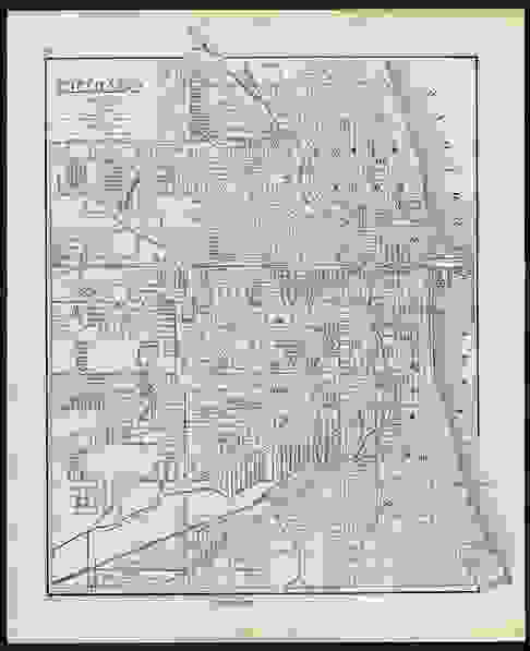
Highly detailed map of Chicago from Gray’s atlas, 1881
Similar Sale History
View More Items in Maps & Atlases


Related Maps & Atlases


![1892 Cowles Civil War Map of Battles in Gettysburg, Virginia, W Virginia and Maryland -- Sketch of: Title: 1892 Cowles Civil War Map of Battles in Gettysburg, Virginia, W Virginia and Maryland -- Sketch of the battle of McDowell, VA. [and] Route Map of Gettysburg Campaign Lt-Gen T.J. Jackson [and] S](https://p1.liveauctioneers.com/5584/329422/177662185_1_x.jpg?height=310&quality=70&version=1715717898)


![1892 Black Map of New Zealand and [on Separate Sheet] Pacific Ocean: Title: 1892 Black Map of New Zealand and [on Separate Sheet] Pacific Ocean Cartographer: A&C Black Year / Place: 1892, Edinburgh Map Dimension (in.): 16.4 X 21.5 in. Largest This is a highly detailed](https://p1.liveauctioneers.com/5584/329422/177662236_1_x.jpg?height=310&quality=70&version=1715717898)
![1892 Black Map of Spain and Portugal Plus [on Separate Sheet] Italy: Title: 1892 Black Map of Spain and Portugal Plus [on Separate Sheet] Italy Cartographer: A&C Black Year / Place: 1892, Edinburgh Map Dimension (in.): 14.8 X 20 in. for Larger This is a highly detailed](https://p1.liveauctioneers.com/5584/329422/177662199_1_x.jpg?height=310&quality=70&version=1715717898)


More Items in Maps & Atlases
View More
![[Maps] Gio. Ant. Magnini, Italia, 1620: [Maps] Gio. Ant. Magnini, Italia, 1620, Giovanni Antonio Magnini. Italia, data in luce da Fabio suo figliuolo al Serenissimo Ferdinado Gonzaga Duca di Matoua edi Monserrato etc. Bologna, for Sebastian](https://p1.liveauctioneers.com/188/326797/176317457_1_x.jpg?height=310&quality=70&version=1713847031)
![[Maps] Martin Zeiler, Itinerarium Italiae, 1640: [Maps] Martin Zeiler, Itinerarium Italiae, 1640, Martini Zeilleri. Itinerarium Italiae Nov-Antiquae: oder, Raiss-Beschreibung durch Italien, Matthaus Merian, Frankfurt, 40 plates, most double-page, in](https://p1.liveauctioneers.com/188/326797/176317459_1_x.jpg?height=310&quality=70&version=1713847031)


![[MAP]. TODESCHI, Pietro. [Nova et Acurata Totius Americae Tabula auct. G.I. Blaeu] America quarta: [MAP]. TODESCHI, Pietro. [Nova et Acurata Totius Americae Tabula auct. G.I. Blaeu] America quarta pars orbis quam plerunq, nuvum orbem appellitant primo detecta est anno 1492 a Christophoro Columbo...](https://p1.liveauctioneers.com/197/329395/177650542_1_x.jpg?height=310&quality=70&version=1715364962)


Recommended Transportation & Travel Collectibles
View More


Item Details
Description
Detailed map of Chicago, published by O.W. Gray & Son in their 1884 National Atlas, an exceedingly difficult atlas to find. Map is colored by wards and shows streets, rail lines, parks, buildings, stations, waterways and a host of other details. Steam railroads and horse (street) railroads are delineated. Exposition Building located and shown. Commercial canals in southwestern part of city shown, with some of them named. One of the earliest maps of Chicago to appear in a commercial atlas. Clean and nicely centered. 12 x 14.875
Reserve: $135.00
Shipping:Domestic: Flat-rate of $8.00 to anywhere within the contiguous U.S. International: Foreign shipping rates are determined by destination. International shipping may be subject to VAT. Combined shipping: Please ask about combined shipping for multiple lots before bidding. Location: This item ships from Ohio
Your purchase is protected:
Photos, descriptions, and estimates were prepared with the utmost care by a fully certified expert and appraiser. All items in this sale are guaranteed authentic.
In the rare event that the item did not conform to the lot description in the sale, Jasper52 specialists are here to help. Buyers may return the item for a full refund provided you notify Jasper52 within 5 days of receiving the item.
Reserve: $135.00
Shipping:
Your purchase is protected:
Photos, descriptions, and estimates were prepared with the utmost care by a fully certified expert and appraiser. All items in this sale are guaranteed authentic.
In the rare event that the item did not conform to the lot description in the sale, Jasper52 specialists are here to help. Buyers may return the item for a full refund provided you notify Jasper52 within 5 days of receiving the item.
Condition
Near fine
Buyer's Premium
- 15%
Highly detailed map of Chicago from Gray’s atlas, 1881
Estimate $160 - $175
1 bidder is watching this item.
Get approved to bid.
Shipping & Pickup Options
Item located in Ohio, US$8 shipping in the US
Payment
Accepts seamless payments through LiveAuctioneers
See More Items From This Jasper52 Seller

TOP