Nevada Map Collection (7) [142678]
Similar Sale History
View More Items in Maps & AtlasesRelated Maps & Atlases
More Items in Maps & Atlases
View MoreRecommended Transportation & Travel Collectibles
View More
![Nevada Map Collection (7) [142678]](https://p1.liveauctioneers.com/2699/249417/129483487_1_x.jpg?quality=1&version=1653350867&width=486)
![Nevada Map Collection (7) [142678]](https://p1.liveauctioneers.com/2699/249417/129483487_1_x.jpg?quality=80&version=1653350867)
Item Details
Description
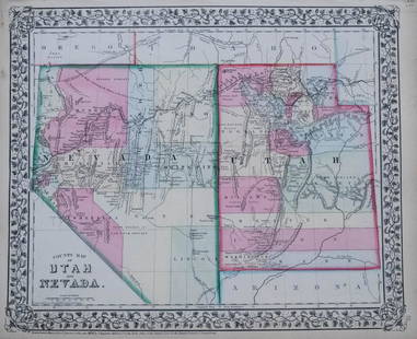
Lot of 7 antiquarian maps of Nevada. All mounted and shrink wrapped in pristine condition. Largest is a County map of NV & UT, Philadelphia: S. Augustus Mitchell Jr., 1870. Lithographed by W.H. Gamble. Map dimensions 14 1/4" x 11 7/8", scale 1" = 50 miles. Smallest is Plate III from the Ninth Edition of the Encyclopedia Britannica, pg 367, dimensions 8 1/4" x 6 3/4", 1 " = approx. 55 miles, date 1880, includes inset map of Carson City area, 1" = approx. 30 miles. Included in this interesting rendering of NV's past is an 1885 NV map from Watson's Atlas; a1895 map from the Atlas of the World, a 1915 map from George F. Cram Company/Chicago; a 1911 Century Atlas Map of NV and UT; and an uncredited map of NV c. 1900. State:Nevada City: Date: Provenance:
Buyer's Premium
- 30%
Nevada Map Collection (7) [142678]
Estimate $240 - $500
Shipping & Pickup Options
Item located in Reno, NV, usOffers In-House Shipping
Local Pickup Available
Payment
Accepts seamless payments through LiveAuctioneers

Related Searches
TOP


![Fur Country of the Far West Map by Hafen [161295]: Red and black Fur Country of the Far West map by Leroy Hafen. A great map of the early West with historical detail. Hafen was born in Nevada in 1893 and died in 1985 in Palm Desert. He was a historian](https://p1.liveauctioneers.com/2699/291514/154451414_1_x.jpg?height=310&quality=70&version=1685892555)


![[MAPS] A COLLECTION OF MAPS SOLD TOGETHER: [MAPS] A collection of maps sold together, including: Bell, A. A NEW CHART OF THE RIVER ST. LAWRENCEFROM THE ISLAND OF ANTICOSTI TO LAKE ONTARIO. London: R. Baldwin, [1759]. Engraved map, 18 x 25 cm.](https://p1.liveauctioneers.com/1124/208511/106199202_1_x.jpg?height=310&quality=70&version=1624388585)

![Map Postcard Collection [137947]: About 60 postcards with maps. Many state maps, but also international, Map of the British Empire, railroad routes and others. Get one for every state!Date: Country (if not USA): State: City: Provenanc](https://p1.liveauctioneers.com/2699/211819/108068744_1_x.jpg?height=310&quality=70&version=1626723835)
![Scottish maps A collection: Scottish maps A collection Blaeu. Duo Vicecomitatus Aberdonia & Banfia, 59 x 46cm, hand-coloured in outline; [Idem] Moravia... 59 x 45cm, hand-coloured in outline; [Idem] Annandiae, 53 x 44cm, hand-co](https://p1.liveauctioneers.com/94/251108/130828920_1_x.jpg?height=310&quality=70&version=1655281539)
![Collection: Maps, Atlases and Calligraphy: Maps, Atlases and Calligraphy. - a collection of 25 volumes (including: D.W. Marshall & H.H. Peckham. Campaigns of the American Revolution. [Ann Arbor, Mich.: 1976], folio. Original cloth, dust-jacket](https://p1.liveauctioneers.com/3975/301526/160693994_1_x.jpg?height=310&quality=70&version=1694182765)


![Large Map of California: Large Map of California With map of Arizona and Nevada [separately] on versos Cartographer: George Franklin Cram Dated: Circa 1900 Type: Color Lithograph Dimensions: 14](https://p1.liveauctioneers.com/5614/330257/178045314_1_x.jpg?height=310&quality=70&version=1716032806)


![[MAP]. TODESCHI, Pietro. [Nova et Acurata Totius Americae Tabula auct. G.I. Blaeu] America quarta: [MAP]. TODESCHI, Pietro. [Nova et Acurata Totius Americae Tabula auct. G.I. Blaeu] America quarta pars orbis quam plerunq, nuvum orbem appellitant primo detecta est anno 1492 a Christophoro Columbo...](https://p1.liveauctioneers.com/197/329395/177650542_1_x.jpg?height=310&quality=70&version=1715364962)


![[MAPS]. HOMANN, Johann Baptist, HOMANN HEIRS, and Georg Matthäus SEUTTER. [Composite Atlas].: [MAPS]. HOMANN, Johann Baptist (1663-1724), HOMANN HEIRS, and Georg Matthäus SEUTTER (1678-1757). [Composite Atlas]. [Nuremberg, Augsburg, and others: Homann Heirs and others, maps dated between](https://p1.liveauctioneers.com/197/329395/177650530_1_x.jpg?height=310&quality=70&version=1715364962)
![[MAP]. ORTELIUS, Abraham. Americae Sive Novi Orbis, Nova Descriptio. 1573.: [MAP]. ORTELIUS, Abraham (1527-1598). Americae Sive Novi Orbis, Nova Descriptio. Antwerp, 1573. Engraved map with hand-coloring. Framed and double glazed, visible area 375 x 521 mm (unexamined out of](https://p1.liveauctioneers.com/197/329395/177650534_1_x.jpg?height=310&quality=70&version=1715364962)


![[MAP]. ORTELIUS, Abraham. Turcici Imperii Descriptio.1592.: [MAP]. ORTELIUS, Abraham (1527-1598). Turcici Imperii Descriptio. Antwerp, 1592. Engraved map with hand-coloring. Matted, framed, and double glazed, sight 406 x 521 mm (unexamined out of frame). Decor](https://p1.liveauctioneers.com/197/329395/177650538_1_x.jpg?height=310&quality=70&version=1715364962)

![[MAP]. ORTELIUS, Abraham. Aevi Veteris, Typus Geographicus. 1601.: [MAP]. ORTELIUS, Abraham (1527-1598). Aevi Veteris, Typus Geographicus. Antwerp, 1601. Engraved map with hand-coloring. Matted, framed, and double glazed, visible area 343 x 470 mm (unexamined out of](https://p1.liveauctioneers.com/197/329395/177650532_1_x.jpg?height=310&quality=70&version=1715364962)


![[FLAGS]. 31-star American parade flag. Ca 1850-1859.: [FLAGS]. 31-star American parade flag. Ca 1850-1859. 22 x 36 1/2 in. cotton flag with 31 printed stars, configured in a double medallion surrounding a much larger central star, that is haloed in both](https://p1.liveauctioneers.com/197/329785/177758218_1_x.jpg?height=310&quality=70&version=1715625218)


