


1764 Bellin plan of Cap Haitien, Haiti -- Ville du Cap dans l'Isle de St. Domingue
Similar Sale History
View More Items in Maps & Atlases


![Bellin: Maps/Views of Aztec & Colonial Mexico City: Title/Content of Map: Carte des Environs de la Ville de Mexico / Ancien Mexico [and on a second sheet] Nouveau Mexico / Carte du lac de Mexico et de ses Environs Cartographer: Bellin / Chedel Place &](https://p1.liveauctioneers.com/5584/114563/58815203_1_x.jpg?height=310&quality=70&version=1514941693)


Related Maps & Atlases
![Environs & Temple of Ablaykit, Kazakhstan. Ablakit. BELLIN 1768 old map: CAPTION PRINTED BELOW PICTURE: Plan des Environs et de l'Enceinte du Temple de Ablakit [Map of the environs and the enclosure of the Temple of Ablaykit] DATE PRINTED: 1768 IMAGE SIZE: Approx 20.0 x 15](https://p1.liveauctioneers.com/5584/329387/177649350_1_x.jpg?height=310&quality=70&version=1715717898)

![[MAP]. SARTINE, Antoine Plan de la Barre et du Havre de Charles-Town...1778. RARE REVOLUTIONARY WAR: [MAP]. SARTINE, Antoine (1729-1801). Plan de la Barre et du Havre de Charles-Town d'apres un plan Anglois leve en 1776... Paris: Depot de la Marine for M. de Sartine, 1778. Copperplate engraving, matt](https://p1.liveauctioneers.com/197/329395/177650540_1_x.jpg?height=310&quality=70&version=1715364962)


![Carte du Golphe de Bothnie'. Gulf of Bothnia. Sweden Finland. BELLIN 1759 map: CAPTION PRINTED BELOW PICTURE: Carte du Golphe de Bothnie [Map of the Gulf of Bothnia] DATE PRINTED: 1759 IMAGE SIZE: Approx 22.5 x 18.0cm, 8.75 x 7 inches (Medium) TYPE: Antique copperplate map CONDI](https://p1.liveauctioneers.com/5584/328641/177014466_1_x.jpg?height=310&quality=70&version=1715113718)
![Carte du Golphe de Bengale'. Bay of Bengal. India Burma Ceylon. BELLIN 1746 map: CAPTION PRINTED BELOW PICTURE: Carte du Golphe de Bengale tiré de la Carte de l'Océan Oriental, Publiée par Ordre de Mgr le Comte De Maurepas [Map of the Bay of Bengal] DATE PRINTED: 17](https://p1.liveauctioneers.com/5584/329387/177649439_1_x.jpg?height=310&quality=70&version=1715717898)


More Items in Maps & Atlases
View More
![[Maps] Gio. Ant. Magnini, Italia, 1620: [Maps] Gio. Ant. Magnini, Italia, 1620, Giovanni Antonio Magnini. Italia, data in luce da Fabio suo figliuolo al Serenissimo Ferdinado Gonzaga Duca di Matoua edi Monserrato etc. Bologna, for Sebastian](https://p1.liveauctioneers.com/188/326797/176317457_1_x.jpg?height=310&quality=70&version=1713847031)
![[Maps] Martin Zeiler, Itinerarium Italiae, 1640: [Maps] Martin Zeiler, Itinerarium Italiae, 1640, Martini Zeilleri. Itinerarium Italiae Nov-Antiquae: oder, Raiss-Beschreibung durch Italien, Matthaus Merian, Frankfurt, 40 plates, most double-page, in](https://p1.liveauctioneers.com/188/326797/176317459_1_x.jpg?height=310&quality=70&version=1713847031)


![[MAP]. TODESCHI, Pietro. [Nova et Acurata Totius Americae Tabula auct. G.I. Blaeu] America quarta: [MAP]. TODESCHI, Pietro. [Nova et Acurata Totius Americae Tabula auct. G.I. Blaeu] America quarta pars orbis quam plerunq, nuvum orbem appellitant primo detecta est anno 1492 a Christophoro Columbo...](https://p1.liveauctioneers.com/197/329395/177650542_1_x.jpg?height=310&quality=70&version=1715364962)


Recommended Transportation & Travel Collectibles
View More


Item Details
Description
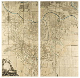
This is a bird's-eye plan Cap Haities (Ville du Cap) in northern Haiti. This plan shows the block-street pattern in detail, with a key in the title cartouche indicating nine sites of interest, such as the fort, cemetery, and a fountain. The city is surrounded by excellent topographical detail. Saint Domingue was a French colony established on the island of Hispaniola in 1659. A compass rose orients north to the right, and the map is embellished with a rococo title cartouche. From Le Petit Atlas Maritime... Volume I.
Reserve: $60.00
Shipping:
Your purchase is protected:
Photos, descriptions, and estimates were prepared with the utmost care by a fully certified expert and appraiser. All items in this sale are guaranteed authentic.
In the rare event that the item did not conform to the lot description in the sale, Jasper52 specialists are here to help. Buyers may return the item for a full refund provided when you notify Jasper52 within 5 days of receiving the item.
Condition
Very good. Slight toning and soiling. On laid paper. Hand colored. Issued centerfold.
Buyer's Premium
- 15%
1764 Bellin plan of Cap Haitien, Haiti -- Ville du Cap dans l'Isle de St. Domingue
Estimate $70 - $80
5 bidders are watching this item.
Shipping & Pickup Options
Item located in Ohio, US$17 shipping in the US
Payment
Accepts seamless payments through LiveAuctioneers
See More Items From This Jasper52 Seller

TOP