


Africa.- Morocco.- Mercator (Gerard) and Claudius
Similar Sale History
View More Items in Maps & Atlases
![EUROPAE. [Ortelius, Ca. 1584-1612.] Map.: [Ortelius, Abraham] EUROPAE. [C. 1584-1612.] Engraved map by Ortelius based on Jenkinson’s Russia map and Gastaldi’s maps of Africa and Asia, Gerard Mercator’s 1564 map of Britain, a map of Scan](https://p1.liveauctioneers.com/179/82189/42599765_1_x.jpg?height=310&quality=70&version=1447864785)
![Hondius Map of Morocco: HONDIUS, Jodocus (1563-1612) / MERCATOR, Gerard (1512-1594). [Morocco] Fessae et Marocchi Regna. Engraving with original hand color. Amsterdam, c. 1606 or later. 17 3/4" x 21" sheet. Comparable: Old W](https://p1.liveauctioneers.com/1968/169571/85465312_1_x.jpg?height=310&quality=70&version=1590242353)


Related Maps & Atlases


![1790 AFRICA TRAVELS Voyages dans le pays des Hottentots ILLUSTRATED antique RARE: Voyages dans le pays des Hottentots, a la Caffrerie, a la baye Botanique, et dans la Nouvelle Hollande [ Travels in the country of the Hottentots, at the Caffrie ] [ Voyages undertaken from 1777 to 17](https://p1.liveauctioneers.com/5584/329751/177744081_1_x.jpg?height=310&quality=70&version=1715718131)


More Items in Maps & Atlases
View More![[Maps] Martin Zeiler, Itinerarium Italiae, 1640: [Maps] Martin Zeiler, Itinerarium Italiae, 1640, Martini Zeilleri. Itinerarium Italiae Nov-Antiquae: oder, Raiss-Beschreibung durch Italien, Matthaus Merian, Frankfurt, 40 plates, most double-page, in](https://p1.liveauctioneers.com/188/326797/176317459_1_x.jpg?height=310&quality=70&version=1713847031)

![[Maps] Gio. Ant. Magnini, Italia, 1620: [Maps] Gio. Ant. Magnini, Italia, 1620, Giovanni Antonio Magnini. Italia, data in luce da Fabio suo figliuolo al Serenissimo Ferdinado Gonzaga Duca di Matoua edi Monserrato etc. Bologna, for Sebastian](https://p1.liveauctioneers.com/188/326797/176317457_1_x.jpg?height=310&quality=70&version=1713847031)


![[MAP]. TODESCHI, Pietro. [Nova et Acurata Totius Americae Tabula auct. G.I. Blaeu] America quarta: [MAP]. TODESCHI, Pietro. [Nova et Acurata Totius Americae Tabula auct. G.I. Blaeu] America quarta pars orbis quam plerunq, nuvum orbem appellitant primo detecta est anno 1492 a Christophoro Columbo...](https://p1.liveauctioneers.com/197/329395/177650542_1_x.jpg?height=310&quality=70&version=1715364962)


Recommended Transportation & Travel Collectibles
View More


Item Details
Description
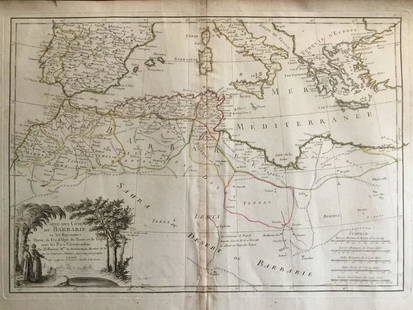
Africa.- Morocco.- Mercator (Gerard) and Claudius Ptolemy. Africae I Tab:, Ptolemaic map of the northwestern part of Africa, filled with ancient names, including the Straits of Gibraltar, here called the Herculeu fretum, engraving with hand-colouring, on thick laid paper without watermark, platemark 330 x 465 mm (13 x 18 1/4 in), sheet 410 x 530 mm (16 x 20 7/8 in), central vertical fold with some old splitting, marginal spotting and surface dirt, unframed, [circa 1578].
Buyer's Premium
- 30% up to £300,000.00
- 25% up to £3,000,000.00
- 17.5% above £3,000,000.00
Africa.- Morocco.- Mercator (Gerard) and Claudius
Estimate £150 - £200
1 bidder is watching this item.
Shipping & Pickup Options
Item located in London, London, ukOffers In-House Shipping
Local Pickup Available
Payment

Auction Curated By

International Head of Books and Works on Paper

Modern First Editions and 20th Century Literature
TOP