


G. Washington Survey! George III Grants to Soldiers,
Similar Sale History
View More Items in Books, Magazines & Papers
![[WASHINGTON, George (1732-1799)]. CLARKE, Thomas,: [WASHINGTON, George (1732-1799)]. CLARKE, Thomas, engraver. Sacred to the Memory of the Illustrious G. Washington. Boston: n.p., 1801. Stipple engraving, sheet 192 x 296 mm (trimmed tightly as usual),](https://p1.liveauctioneers.com/197/119933/61101228_1_x.jpg?height=310&quality=70&version=1523904666)


Related Books, Magazines & Papers

![Monographs of the U.S. Geological Survey [181658]: Rare. Hardcover, 486 pages; 9 x 12 inches. "Department of the Interior Monographs of the United States Geological Survey Volume XIII." Washington Government Printing Office 1888. "Geology of the Quick](https://p1.liveauctioneers.com/2699/331499/178846288_1_x.jpg?height=310&quality=70&version=1717355722)


![1792 Bill of Rights The Columbian Centinel Newspaper: Historical issue of the Bill of Rights newspaper The Columbian Centinel, Boston. Dated Saturday April 28, 1792. Printed by Benjamin Russell. No 14 of volume XVII [14], number 3, Includes texts with th](https://p1.liveauctioneers.com/6087/332305/179222973_1_x.jpg?height=310&quality=70&version=1717439546)
![Orange County History Reference Books, 1963-86 (4) [181339]: A collection of four books about Orange County, CA, two specifically Placentia, CA. Includes: Historical Volume and Reference Works, Vols. I and II, Orange County, factual history of Orange County fro](https://p1.liveauctioneers.com/2699/331494/178785521_1_x.jpg?height=310&quality=70&version=1717118335)
![Southwest Historical Series, Bieber, Hafen, Vol. I-XII, 1931-1943 [182452]: (12) Books, the Arthur H. Clark Company, Southwest Historical Series, Volume I-XII, Edited by Ralph P. Bieber and LeRoy R. Hafen, 1931-1943, complete set. This series is an archive of the history of t](https://p1.liveauctioneers.com/2699/331494/178785491_1_x.jpg?height=310&quality=70&version=1717094654)
![Statistics and Technology of the Precious Metals [181871]: Hardcover, 541 pages. "Statistics and Technology of the Precious Metals," by S. F. Emmons and G. F. Becker. Washington Government Printing Office, 1885. Leather binding, slightly torn.](https://p1.liveauctioneers.com/2699/331494/178785613_1_x.jpg?height=310&quality=70&version=1717094654)


![Mining Related Professional Papers U.S. Geological Survey Lindgren 1911; Knopf 1929 [183997]: (2) Professional papers from the Department of the Interior U.S Geological Survey: "The Tertiary Gravels of the Sierra Nevada of California" by Waldemar Lindgren, Washington Government Printing Office](https://p1.liveauctioneers.com/2699/331494/178785586_1_x.jpg?height=310&quality=70&version=1717094654)
More Items in Contemporary Books, Magazines & Papers
View More

Recommended Collectibles
View More


Item Details
Description
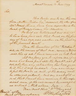
G. Washington Survey! George III Grants to Soldiers, "a small Elm marked G.W. standing on the bank of the river Ohio" 6 pages
This contemporary manuscript of the 1772 land grant by King George III granted 28,627 acres of land along the Ohio River to 61 men who responded to a February 19, 1754, proclamation by Governor Robert Dinwiddie (1692-1770) to enlist "in the service of Our late royal Grandfather for the defence and security" of Virginia during the French and Indian War.
The description of the land began at "a small Elm marked G.W. standing on the bank of the river Ohio, Directly at the point between the said river and the mouth of the lower or big sandy Creek." The "G.W." marking meant either that George Washington surveyed the land or that the markings staked his claim to an adjacent tract of 2,448 acres, one of the grants that he received for his service in the French and Indian War.
In October 1770, Washington, Dr. James Craik, and three of their servants traveled to the Ohio River to examine western lands. On October 28, they met Kiashuta, one of the Six Nation Chiefs who had fought with Washington against the French in 1753. The next morning, they continued on to "a Creek with fallen Timber at the Mouth on which the Indians say there is wide bottom's, & good Land." The editors of the Washington diaries identified this creek as "Big Sandy Creek," which enters the Ohio River at modern-day Ravenswood, West Virginia. They also noted that Washington later acquired 2,448 acres of bottomland in this area. Washington may have marked the trees mentioned in this land grant at this time, or more likely, his surveyor and land agent William Crawford (1722-1782) made the marks when he surveyed the area for Washington in June 1771.
[GEORGE WASHINGTON.] GEORGE III, Manuscript Document, Copy of Land Grant, December 15, 1772, Williamsburg, Virginia. 6 pp., 7.75" x 12.25". Folds and tears at folds; brown spots at corners and edges; areas of ink fading.
Excerpts
"George the third by the grace of god of great Britain, France and Ireland King defender of the faith &c. To all to whom these presents shall come greeting. Know ye that for divers good causes and considerations but more especially for the consideration mentioned in a proclamation of Robert Dinwiddie Esqr late Lieutenant Governor and Commander in Chief of Our Colony and Dominion of Virginia bearing date the nineteenth day of February 1754 for encouraging men to enlist in the service of Our late royal Grandfather for the defence and security of the said Colony, We have given, granted and Confirmed, and by these presents for us Our Heirs and successors, do give, grant and confirm unto John Savage, [60 more names], One certain tract or parcel of Land Containing 28627 Acres, Lying and being in the County of Fincastle and bounded as follows, to wit, Beginning at a small Elm marked G.W. standing On the bank of the river Ohio, Directly at the point between the said river and the mouth of the lower or big sandy Creek [detailed description of land with five more mentions of trees marked "G.W."] with all woods, underwoods, swamps, marshes, low grounds, meadows, feedings and their due share of all seams mines and quarries, as well discovered as not discovered within the bounds aforesaid, and being of the said quantity of 28627 acres of land, and the rivers, waters, and water courses, therein contained together with the privileges of Hunting, Hawking, Fishing, Fowling, and all other profits commodities, and Hereditaments whatsoever to the same Or any part thereof belonging or in any wise appertaining, to have, hold, possess, and enjoy the said tract of land and all other the before granted premises...."
"paying unto Us, Our Heirs and Successors for every 50 Acres of land, and so proportionably for a lesser or greater quantity than 50 Acres the fee rent of One shilling yearly to be paid upon the feast of Saint Michael the Archangel next after 15 years from the date of these presents, and also Cultivating and Improving 3 Acres part of every fifty of the tract Abovementioned within three years after the date of these presents...."
"In witness we have Caused these our Letters patent to be made witness Our Truly and well beloved John Earl of Dunmore at Williamsburgh Under the seal of Our said Colony the 15th Day of December 1772 in the thirteenth year of Our reign."
Historical Background
In February 1754, Virginia Royal Governor Robert Dinwiddie promised volunteers who enlisted to protect the colony's western borders against the French and Indians a part of 200,000 acres of western land.
George Washington petitioned the Virginia Council in 1769 to fulfill Dinwiddie's promise from fifteen years earlier. He suggested that the land be granted from several surveys on the Monongahela River, the New River, and from the "falls of the Great Cawhawa to Sandy Creek." On December 15, 1769, the Council issued an order to make a grant of 200,000 acres and permitted no more than twenty surveys that did not interfere with prior settlements to be made.
In November 1772, the Council approved several grants based on the thirteen surveys that had been thus far completed, including this grant of 28,627 acres. The first claimant listed, John Savage, served as a lieutenant with Washington in the Fort Necessity campaign, was a captain in Washington's Virginia Regiment of 1755, and received 3,428 acres. The next four men were serjeants and received 600 acres each. The next four were corporals, who received 500 acres each. Finally, the remaining fifty-two men were privates who received 400 acres each.
At the same time, the Council approved four grants to Col. Washington, for 10,990 acres, 4,395 acres, 2,448 acres, and 2,314 acres respectively, based on his share of 15,000 acres and his purchase of 5,000 acres from George Muse and 600 acres from Sergeant Brickner. The following month, then Virginia Governor John Murray 4th Earl of Dunmore (1730-1809) issued this grant to John Savage and the sixty other veterans and four separate grants to Washington.
A notice in the February 10, 1774, issue of the Virginia Gazette in Williamsburg announced, "It is absolutely necessary that the sundry Claimants in the Patent granted to Mr. John Savage, and others, who were with Colonel George Washington at the Battle of the Meadows, for 28,627 Acres of Land on the Great Sandy Creek, a Branch of the Ohio, should have a Meeting, to fix on a Time for making a Division of the said Land, and to pay off the contingent Expences attending the first Survey." A majority of the claimants met on March 5 in Winchester and again on May 20. In May 1775, they met at the confluence of the Great Kanawaha" to divide the land.
This item comes with a Certificate from John Reznikoff, a premier authenticator for both major 3rd party authentication services, PSA and JSA (James Spence Authentications), as well as numerous auction houses.
WE PROVIDE IN-HOUSE SHIPPING WORLDWIDE.
Buyer's Premium
- 25%
G. Washington Survey! George III Grants to Soldiers,
Shipping & Pickup Options
Item located in Wilton, CT, usPayment

Auction Curated By
