


1640 Jansson Map of Rhine River Area in Netherlands and
Similar Sale History
View More Items in Maps & Atlases


![1893 Civil War Map of Murfreesborough TN Area -- Map of the Battle of Murfreesborough [with]: Title: 1893 Civil War Map of Murfreesborough TN Area -- Map of the Battle of Murfreesborough [with] ...Stone River Campaign… [with] …Battlee Before Murfreesborough, Tenn... [Plate XXXI] Cartograph](https://p1.liveauctioneers.com/5584/293457/155766022_1_x.jpg?height=310&quality=70&version=1687903812)


Related Maps & Atlases

![1593 de Jode Maps of Eastern Germany (Saxony Area) and Western Germany -- Mansfeldiae Comitatus ...: Title: 1593 de Jode Maps of Eastern Germany (Saxony Area) and Western Germany -- Mansfeldiae Comitatus ... [on sheet with] Clivensis et Iuliacensis Ducatum Cartographer: G De Jode Year / Place: 1593,](https://p1.liveauctioneers.com/5584/330117/177981830_1_x.jpg?height=310&quality=70&version=1716324705)


More Items in Maps & Atlases
View More

![[MAP]. TODESCHI, Pietro. [Nova et Acurata Totius Americae Tabula auct. G.I. Blaeu] America quarta: [MAP]. TODESCHI, Pietro. [Nova et Acurata Totius Americae Tabula auct. G.I. Blaeu] America quarta pars orbis quam plerunq, nuvum orbem appellitant primo detecta est anno 1492 a Christophoro Columbo...](https://p1.liveauctioneers.com/197/329395/177650542_1_x.jpg?height=310&quality=70&version=1715364962)


![[MAPS]. HOMANN, Johann Baptist, HOMANN HEIRS, and Georg Matthäus SEUTTER. [Composite Atlas].: [MAPS]. HOMANN, Johann Baptist (1663-1724), HOMANN HEIRS, and Georg Matthäus SEUTTER (1678-1757). [Composite Atlas]. [Nuremberg, Augsburg, and others: Homann Heirs and others, maps dated between](https://p1.liveauctioneers.com/197/329395/177650530_1_x.jpg?height=310&quality=70&version=1715364962)


Recommended Transportation & Travel Collectibles
View More


Item Details
Description
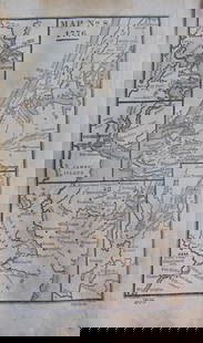
These two attractive maps are on one double-page sheet and portray the lower portion of Rhine River from Wesel, Germany to nearly Rotterdam. The upper map is of the Netherlands along the Rhine, showing cities including Wageninge (Wageningen), Rheenen (Rhenen) and 's-Hertogenbosch. The bottom map is a continuation of the upper map, starting around Nimmegen (Nijmegen) and Arnhem, and passes over the German border up river to show Emmerich (Emmerich am Rhein) and Wes(s)el among others. The maps are rich in detail as to topography, forests, canals, etc.
Reserve: $150.00
Shipping:
Your purchase is protected:
Photos, descriptions, and estimates were prepared with the utmost care by a fully certified expert and appraiser. All items in this sale are guaranteed authentic.
In the rare event that the item did not conform to the lot description in the sale, Jasper52 specialists are here to help. Buyers may return the item for a full refund provided you notify Jasper52 within 5 days of receiving the item.
Condition
Very good. Slight soiling in the ample margins. Issued centerfold. Hand colored.
Buyer's Premium
- 15%
1640 Jansson Map of Rhine River Area in Netherlands and
Estimate $200 - $250
2 bidders are watching this item.
Shipping & Pickup Options
Item located in Ohio, US$15 shipping in the US
Payment
See More Items From This Jasper52 Seller

Auction Curated By

Maps Expert
Related Searches
TOP