


Done
New York, NY, United States
Auction Details
Antique Maps of West Indies & Caribbean
The sale features antique maps & antique prints of the West Indies, the Caribbean Sea, the Gulf of Mexico & the Caribbean Islands. We have maps of the Windward & Leeward islands including Barbados, St Lucia, Antigua; the U.S. & British Virgin Islands, Jamaica, Cuba, Hispaniola, the Bahamas, Puerto Rico. The sale also includes charts of Antilles fran?aises: Martinique, Guadeloupe & St Barts, and the Dutch West Indies. Our stock includes Bryan Edwards' maps of the British West Indies, plans from Aspinall's "pocket guide" to the region, views from Reclus's "Universal Geography" and old engravings of shipwrecks, hurricanes and pirates.
Lot Number: Lowest
24

0001: CARIBBEAN West Indies Central America Danish Virgin islands JOHNSTON 1901 mapEst. $50-$60Lot Passed
![The Consolidated Slave Act of Jamaica 1792. 40 pages. Bryan Edwards 1794 print: Title: The Consolidated Slave Act of Jamaica 1792. 40 pages. Bryan Edwards 1794 printDescription: Appendix to Book IV - The Consolidated Slave Act of Jamaica 1792 [Page 157-196]. Published by Bryan](https://p1.liveauctioneers.com/5584/311298/166542573_2_x.jpg?height=310&quality=70&version=1701811430)
0002: The Consolidated Slave Act of Jamaica 1792. 40 pages. Bryan Edwards 1794 printEst. $200-$250Lot Passed

0003: Havana Harbour, Cuba. Caribbean. ADMIRALTY sea chart 1954 (1955) old mapEst. $250-$300Lot Passed
Sold
0004: Ile de GUADELOUPE Marie-Galante Saintes Désirade. Antilles françaises 1876 mapEst. $40-$50
See Sold Price

0005: Amér Sep Porto Rico #69 Puerto Rico & Virgin Islands VANDERMAELEN 1827 old mapEst. $300-$350Lot Passed

0006: WEST INDIES. Outside a West Indian Court House 1905 old antique print pictureEst. $30-$40Lot Passed

0007: WEST INDIES.Caribbean Inset Barbados Dominica Trinidad St Lucia Grenada 1910 mapEst. $30-$40Lot Passed

0008: JAMAICA. Counties/parishes. Sugar Mill & Kingston views. RAPKIN/TALLIS 1851 mapEst. $150-$200Lot Passed

0009: GUADELOUPE. Basse-Terre; Pointe-à-Pitre. St-Martin Saint-Barthélemy 1931 mapEst. $30-$40Lot Passed
![Amér. Sep. Ile de Cuba #67. Cuba & Jamaica Cayman Islands. VANDERMAELEN 1827 map: Title: Amér. Sep. Ile de Cuba #67. Cuba & Jamaica Cayman Islands. VANDERMAELEN 1827 mapDescription: Amér. Sep. - Ile de Cuba [Ile de Cuba] - No. 67 by Philippe Marie Guillaume Vandermaelen.](https://p1.liveauctioneers.com/5584/311298/166542581_2_x.jpg?height=310&quality=70&version=1701811430)
0010: Amér. Sep. Ile de Cuba #67. Cuba & Jamaica Cayman Islands. VANDERMAELEN 1827 mapEst. $300-$350Lot Passed
Sold
0011: WEST INDIES. Lesser Antilles; maps of Jamaica; Guyana 1907 old antiqueEst. $30-$40
See Sold Price

0012: The Bahamas, Cuba & Bermuda "or Summer Islands". THOMSON 1817 old antique mapEst. $300-$350Lot Passed

0013: Florida Strait & Keys. Northern Cuba. ADMIRALTY sea chart 1890 (1955) old mapEst. $250-$300Lot Passed
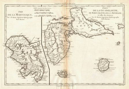
0014: Martinique, Guadeloupe, Marie-Galante, La Désirade & Saintes. BONNE 1788 mapEst. $40-$50Lot Passed

0015: Jamaica. Counties, parishes & railways. WASHINGTON EVES 1889 old antique mapEst. $100-$120Lot Passed

0016: WEST INDIES. Guadeloupe. Tardieu 1830 old antique vintage map plan chartEst. $80-$100Lot Passed
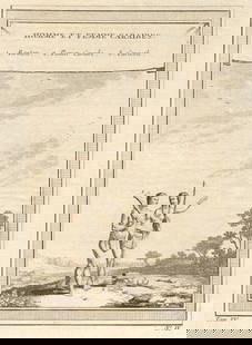
0017: Homme et Femme Caraïbes'. Carib man & woman. Caribbean. Basket Caracoli 1759Est. $40-$50Lot Passed

0018: WEST INDIES. A Gingerbread-Seller, St. Lucia 1905 old antique print pictureEst. $30-$40Lot Passed

0019: First Indians meeting Christopher Columbus. San Salvador Island, Bahamas 1754Est. $40-$50Lot Passed

0020: Gulf of Mexico. Caribbean West Indies. USCGS sea chart 1928 (1930) old mapEst. $150-$200Lot Passed

0021: Cuba, the Bahamas & Bermuda "or Summer Islands". THOMSON 1817 old antique mapEst. $300-$350Lot Passed

0022: A Map of the Island of GRENADA', by Bryan EDWARDS. West Indies. Caribbean 1794Est. $200-$250Lot Passed

0023: GUADELOUPE & MARIE-GALANTE. Soufrière. Dugommier. Antilles. VUILLEMIN 1879 mapEst. $50-$60Lot Passed
![Carte de l'Isle de la Barbade'. Barbados. West Indies. BELLIN 1759 old map: Title: Carte de l'Isle de la Barbade'. Barbados. West Indies. BELLIN 1759 old mapDescription: Carte de l'Isle de la Barbade [Map of the Island of Barbados] by Jacques-Nicolas Bellin (1759). Antique](https://p1.liveauctioneers.com/5584/311298/166542595_2_x.jpg?height=310&quality=70&version=1701811430)
0024: Carte de l'Isle de la Barbade'. Barbados. West Indies. BELLIN 1759 old mapEst. $200-$250Lot Passed
View:
24
Auction Details

Bid Increments
PriceBid Increment
$0$1
$10$5
$100$10
$200$20
$500$50
$1,000$100
$2,000$200
$5,000$500
$10,000$1,000
$20,000$2,000
TOP