


Done
New York, NY, United States
Auction Details
Select Antique Maps from a Private Collection
Authentic antique maps from a collection of over 10,000 cartographic documents. All maps are original, antique maps from 125 to 395 years old—there are no reproductions in this sale.
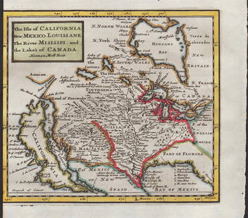
Several hand-colored maps are included from the 1701 first edition of Herman Moll’s iconic geography, including two that show California as an island. A number of maps are offered from the nearly rare, true first edition of Samuel Mitchell’s
first atlas after taking over Henry Tanner’s company in 1846.
Maps also appear from the true first edition of Mitchell, Jr’s first atlas, the first 1860 edition that appeared in just the first quarter of the year before being revised. It is also an extremely scarce atlas. Of special note are extremely scarce items like the rare 1906 lithograph of the San Francisco
fire by Ficke/Roesch, Lt. Robt. E. Lee’s 1837 map of the St. Louis Harbor, Shields 1854 wall map of Boston and Monk’s impressive 1854 wall map of the United States. Other maps to be offered are from Mathew Carey’s scarce 1816 General Atlas, Anthony Finley’s extremely scarce 1833 atlas, the Cowperthwait atlas of 1853, Mitchell atlas editions of 1863 and 1874, and examples from Colton, Johnson, Mercator, Mallet, Morden, Vaugondy, Von Spruner, Gray and McNally. Conditions of the maps vary, but all items are sound and nearly all of them are in Very Good or better condition. Shipping is combined for multiple purchases.
Lot Number: Lowest
24
Sold
0001: Scarce 1701 1st ed. map of Florida, western America & MexicoAn uncommon map of Florida and the areaEst. $475-$550
See Sold Price
Sold
0002: Very scarce 1701 1st ed. map of America from Herman Moll’s GeographyEst. $450-$550
See Sold Price

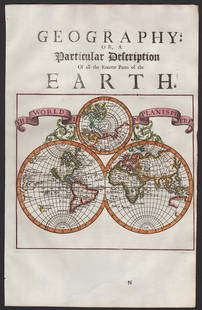
0005: Scarce 1st ed. map of the world from Moll’s System of Geography, 1701Est. $425-$475Lot Passed


View:
24
Auction Details

Bid Increments
PriceBid Increment
$0$1
$10$5
$100$10
$200$20
$500$50
$1,000$100
$2,000$200
$5,000$500
$10,000$1,000
$20,000$2,000
TOP