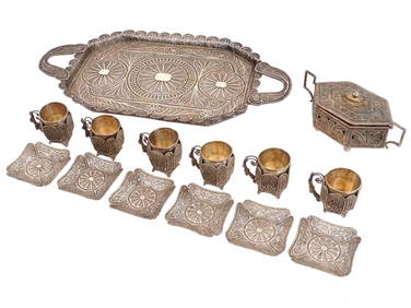
Sold2019* SPEED, John (1551/52-1629). The Turkish Empire.* SPEED, John (1551/52-1629). The Turkish Empire. [London], ca 1627-1632. Engraved map with modern hand coloring of the Turkish empire, English text on verso, visible area 15 5/8 x 20 1/4 in. (398 x 5See Sold Price
Sold2020John Speed Map of the Turkish Empire 1626John Speed (ca. 1551-1629) "The Turkish Empire," London: G. Humble, 1626. This hand-colored map of what is now Turkey and the surrounding areas features a detailed border along the top edge of inset mSee Sold Price
Sold2022TURKISH EMPIRE AND ASIA MINOR SPEED (JOHN) The Turkish Empire, 1676; and 7 other maps of Turkish...TURKISH EMPIRE AND ASIA MINOR SPEED (JOHN) The Turkish Empire, double-page engraved map, 8 city views (including Constantinople, Damascus, Jerusalem and Alexandria) in upper border, 10 costumed figurSee Sold Price
Sold2022[Ottoman Empire] - Speed, John The Turkish Empire[Ottoman Empire] - Speed, John The Turkish Empire London: G. Humble, [1626] Hand-coloured engraved map, English text on verso, 395 x 515mmSee Sold Price
Sold2022MAP OF THE TURKISH EMPIREdated 1626 lower left; inscribed "Newly augmented by John Speed. 1626"; in double-sided frame; 16 1/4 x 21 inches; 23 x 27 inches frameSee Sold Price
Sold2022Speed, John (1552-1629) The Historie of Great Britaine under the Conquests of the Romans, Saxons,Speed, John (1552-1629) The Historie of Great Britaine under the Conquests of the Romans, Saxons, Danes, and Normans. London: Printed by John Dawson for George Humble, 1632.Two folio volumes, third edSee Sold Price
Sold2022Speed, John (1552?-1629) The Historie of Great Britaine under the Conquests of the Romans, Saxons,Speed, John (1552?-1629) The Historie of Great Britaine under the Conquests of the Romans, Saxons, Danes and Normans.See Sold Price
Sold2024Speed Map of Wilshire showing StonehengeSPEED, John (1551-1629). Wilshire [Insets of Salisbury & Stonehenge]. Engraved map with original hand color. London: Speed, 1612. 16 5/8" x 22" sheet.See Sold Price
Sold2019* SPEED, John (1552-1629). Holy Iland / Garnsey / Farne* SPEED, John (1552-1629). Holy Iland / Garnsey / Farne / Iarsey. [London,] 1610 [but 1676]. Hand-colored engraved map of Holy Island and Lindisfarne off the Northumberland Coast, and Guernsey and JerSee Sold Price
Sold2023 [MAPS]. SPEED, John (1551-1629). Rutlandshire with Oukham a...[MAPS]. SPEED, John (1551-1629). Rutlandshire with Oukham and Stanford her bordering Neighbour Newley described. London, 1676. Engraved map with hand-coloring (394 x 508 mm). Includes multiple coats oSee Sold Price
Sold2016Speed map of Turkish Empire 1626Heading: Author: Speed, John Title: The Turkish Empire. Newly Augmented by Iohn Speed 1626 Place Published: London Publisher:G. Humble Date Published: 1626 Description: CopSee Sold Price
Sold2018Speed map of Turkish Empire 1676Heading: Author: Speed, John Title: The Turkish Empire. Newly Augmented by Iohn Speed 1626 Place Published: Thomas Basset & Richard Chiswell Publisher: Date Published: 1676 DescriptionSee Sold Price
Sold2023John Speed (1552 – 1629) A new and Accvrat Map of the world 1651Description: John Speed (1552 – 1629) A new and Accvrat Map of the world 1651 Measurement approximate:Material: PaperSee Sold Price
Sold2015Kingdom of IrelandJohn Speed (1552-1629). Engraved map. London: 1610 (1676). 17 1/4 x 22 inches. A rare, early printing of John Speed’s renowned map of Ireland. The map is decorated with a panel of costume figures deSee Sold Price
Sold2016The Kingdom of ChinaJohn Speed (1552-1629). Copperplate Engraved Map. Abraham Goos & John Speed: 1627. 17 1/4 x 21 1/2 inches. This superb map of China, Korea and Japan is the only carte-a-figures map made of the region.See Sold Price
Sold20172 Antique Engraved Maps. "A New Description ofCarolina" hand colored and engraved map by Francis Lamb (fl. 1667 - 1701) and John Speed (1552 - 1629), plate - 14.5" high x 20.25" wide, tear / old repair upper left, center crease, toned paper, framSee Sold Price
Sold2023Map Showing the Roman Empire-John Speed-Late 17th CenturyMap titled "A New Mappe of the Romane Empire" by John Speed and published by Bassett and Chiswell, circa 1676. Sheet shows map at center surrounded by vignettes of various cities and views of variousSee Sold Price
Sold20171626 John Speed Newe Mape of TartaryDESCRIPTION: Map of "A Newe Mape of Tartary" (Russian Empire) by John Speed. Hand colored copper engraving on laid paper from Speed's "Prospect of the Most Famous Parts of the World" published in 1626See Sold Price
Sold2016JOHN SPEED (BRITISH, 1552-1629) MAP OF THE WORLDJOHN SPEED (BRITISH, 1552-1629) MAP OF THE WORLD, (UPDATED 6/14/16) hand-colored engraving on laid paper, titled "A New and Accurat Map of the World Drawne according to ye truest Descriptions latest DSee Sold Price
Sold2022John Speed, Two Vintage Copper Engraved MapsJOHN SPEED (British, 1552-1629), Invasions of England & Ireland with al their Civill Wars Since the Conquest, 1676, and Britain as it was Divided, two copper engraved maps with hand-coloring, image (eSee Sold Price
Sold2021After John Speed. Map of Virginia and MarylandAfter John Speed (English, 1552-1629). A hand-colored engraved map of Virginia and Maryland, engraved by Francis Lamb (English, 1651-1700). Sold by Thomas Basset in Fleet Street and Richard Chiswell iSee Sold Price
Sold2022MAPS: John Speed (England, 1552-1629), threeMAPS: John Speed (England, 1552-1629), three hand-colored maps on paper: one a map of Suffolk with town plan of Ipswich, dated 1610 in block, described and divided into hundreds, inset plan of IpswichSee Sold Price
Sold2021After John Speed. Map of GermanyAfter John Speed (English, 1552-1629). A hand-colored engraved map titled "A New Mape of Ye XVII Provinces of Low Germanie". Dated 1626. Framed under glass. Mat opening: 16in x 21in. Provenance: FromSee Sold Price
Sold201517th C. John Speed, Huntington & Ely MapJohn Speed (British, 1552-1629), "Huntington, both Shire and Shire Town with the ancient citie Ely Described," hand colored, double engraved-page map originally created by noted cartographer, John SpeSee Sold Price
BonhamsSPEED (JOHN) AND WILLEM BLAEU Pictorial title-pages to Speed's 'Theatre of the Empire of Great B...£10
2 days LeftMark Louis Weseloh Estate Liquidations17th cent. John Speed Map of the Isle of Man. Hand Colored, 22" x 17 1/2",$300
6 days LeftSimpson Galleries, LLC.JODOCUS HONDIUS (1563-1612) A JACOBEAN MAP, "Northamptonshire," AMSTERDAM, 1610$150
BonhamsSPEED (JOHN) Yorkshire; The North and East Ridins of Yorkshire; West Ridinges, [c.1730], hand-co...£10
BonhamsSPEED (JOHN) The Kingdome of China Newly Augmented by I.S. 1626, Thomas Bassett and Richard Chis...£900
BonhamsHERBERT (THOMAS) Some Yeares Travels into Divers Parts of Africa, Asia the Great. Describing Mor...£500
Featured2 days LeftJasper521619-1620 BIBLE in ENGLISH by B.Norton,J.Bill,Robert Barker antique ILLUSTRATED$1,900
Jun 11John Moran Auctioneers, Inc.Chester Arnold (b. 1952), "Till + Tweed, Slaw + Speed," 1995$500(1 bid)
BonhamsGIBBON (EDWARD) The History of the Decline and Fall of the Roman Empire, 6 vol., FIRST EDITION o...£700
2 days LeftMynt AuctionsJohn Williams Composer Star Wars ESB Signed Custom Framed Photo Display PSA/DNA$10(1 bid)
3 days LeftMynt Auctions(4) Elway Sharpe Davis & McCaffrey Signed Lunar F/S Speed Proline Helmet BAS$10
2024Gold Coast Auctioneers17th-19th c. French Wall Art Collection Map City Sea Scapes Scenes etc.See Sold Price
Jun 28Galerie Zacke A BROWN-GLAZED STONEWARE LIME JAR IN THE FORM OF A CAPARISONED ELEPHANT, ANGKOR PERIOD€1,000


![* SPEED, John (1551/52-1629). The Turkish Empire.: * SPEED, John (1551/52-1629). The Turkish Empire. [London], ca 1627-1632. Engraved map with modern hand coloring of the Turkish empire, English text on verso, visible area 15 5/8 x 20 1/4 in. (398 x 5](https://p1.liveauctioneers.com/197/139716/70820696_1_x.jpg?height=310&quality=70&version=1554835829)


![[Ottoman Empire] - Speed, John The Turkish Empire: [Ottoman Empire] - Speed, John The Turkish Empire London: G. Humble, [1626] Hand-coloured engraved map, English text on verso, 395 x 515mm](https://p1.liveauctioneers.com/94/251108/130828918_1_x.jpg?height=310&quality=70&version=1655281539)


![Speed Map of Wilshire showing Stonehenge: SPEED, John (1551-1629). Wilshire [Insets of Salisbury & Stonehenge]. Engraved map with original hand color. London: Speed, 1612. 16 5/8" x 22" sheet.](https://p1.liveauctioneers.com/1968/314554/168606352_1_x.jpg?height=310&quality=70&version=1704142666)
![* SPEED, John (1552-1629). Holy Iland / Garnsey / Farne: * SPEED, John (1552-1629). Holy Iland / Garnsey / Farne / Iarsey. [London,] 1610 [but 1676]. Hand-colored engraved map of Holy Island and Lindisfarne off the Northumberland Coast, and Guernsey and Jer](https://p1.liveauctioneers.com/197/138502/70223743_1_x.jpg?height=310&quality=70&version=1553021481)
![[MAPS]. SPEED, John (1551-1629). Rutlandshire with Oukham a...: [MAPS]. SPEED, John (1551-1629). Rutlandshire with Oukham and Stanford her bordering Neighbour Newley described. London, 1676. Engraved map with hand-coloring (394 x 508 mm). Includes multiple coats o](https://p1.liveauctioneers.com/928/301544/160920971_1_x.jpg?height=310&quality=70&version=1694462960)


![[MAP]. SPEED, John. A New Mappe of the Romane Empire. 1676. (1 of 2)](https://p1.liveauctioneers.com/197/329395/177650541_1_x.jpg?height=282&quality=70&version=1715364962)


![SPEED (JOHN) Yorkshire; The North and East Ridins of Yorkshire; West Ridinges, [c.1730], hand-co... (1 of 3)](https://p1.liveauctioneers.com/1043/319451/178359108_1_x.jpg?height=282&quality=70&version=1717077792)

![[MAP]. ORTELIUS, Abraham. Turcici Imperii Descriptio.1592. (1 of 2)](https://p1.liveauctioneers.com/197/329395/177650538_1_x.jpg?height=282&quality=70&version=1715364962)