Sold2017LOT (5) ENGRAVED MAPS INCLUDING MARTINIQUE, FROM PETITLOT (5) ENGRAVED MAPS INCLUDING MARTINIQUE, FROM PETIT ATLAS NATIONAL, 19TH CENTURY, 10 X 8"; WINDWARD ISLANDS (ST. LUCIA, ST. VINCENT AND BARBADOS), T. KITCHIN, 18TH CENTURY, 10 1/4 X 8"; ANTILLES ORSee Sold Price
Sold2017Baldwin / Kitchin: Antique Maps Windward Islands, 1782Title/Content of Map: 1782 Baldwin / Kitchin Maps of the Windward Islands -- Island of St. Lucia [on sheet with] Island of St. Vincent [on sheet with] Island of Barbados [on sheet with] Chart of PartSee Sold Price
Sold2024WEST INDIES Caribbean Windward Leeward Islands Barbados Pirates? MALLET 1683 mapTITLE OF THE MAP: 'Isles Caribes' (De L'Amerique) The map covers the islands between Puerto Rico and Trinidad. DATE PRINTED: 1683 IMAGE SIZE: Approx Overall page size 13 x 21cm approximately (5 x 8 inSee Sold Price
Sold2018BRITISH WEST INDIES ISLANDS. Jamaica Antilles VirginTITLE/CONTENT OF MAP: 'THE BRITISH ISLANDS IN THE WEST INDIES; Jamaica, Trinidad, Virgin Islands, Leeward Islands (St Christopher, Nevis, Barbuda, Antigua), St Lucie, St Vincent, Barbadoes, Tobago, DoSee Sold Price
Sold2024AFRICAN ISLANDS.Mauritius Madagascar Madeira Canaries St Helena 1897 old mapTitle: AFRICAN ISLANDS.Mauritius Madagascar Madeira Canaries St Helena 1897 old map Description: Madagascar; St. Helena; Cape Town; Aden; Ascension; Mauritius; Socotra; Perim I. and Aden; Amirante andSee Sold Price
Sold2022Levi Wells Prentice "Canada Side, 1000 Islands"Levi Wells Prentice (American, 1851-1935) CT artist "Canada Side, 1000 Islands St. Lawrence River", oil on canvas, signed "L. W. Prentice", 7-3/4" x 12", good condition, paint loses at edges, Losses aSee Sold Price
Sold2023An American Silver Five-Piece Tea and Coffee Service with Matching TrayAn American Silver Five-Piece Tea and Coffee Service with Matching Tray Gorham Mfg. Co., Providence, Rhode Island, Circa 1896 to 1898 comprising a kettle on stand, coffee pot, tea pot, cream pitcher aSee Sold Price
Sold2019Camille Pissarro - Pastel On PaperPastel on paper, Camille Pisarro approx. 20x14 in. Camille Pissarro was a Danish-French Impressionist and Neo-Impressionist painter born on the island of St Thomas. His importance resides in his contrSee Sold Price
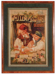
Sold2017Lemp Brewing Co. St. Louis LithographWm. J. Lemp Brewing Co. St. Louis, U.S.A. 1896 Calendar lithograph on paper, framed 39.4'' x 29.3'', made by The Milwaukee Litho. & Engr. Co., a little discoloring on top edge, side edge wrinkled, disSee Sold Price
Sold2017Very Fine ANNA POTTERY / 1889 Stoneware Pig Flask w/Very Fine Cobalt-Decorated Stoneware Pig Flask with Incised Railroad Map, Inscribed "St. Louis the future Great / Latest and Only Reliable / Rail Road and River Guide / By / Anna Pottery / 1889", WallSee Sold Price
Sold2022SAM DOYLE (1906 - 1985)Sam Doyle. St. Helena Island, SC. Born 1906, Died 1985. purchased from the 1998 sale of the Warren and Silvia Lowe collection at lot #49. This piece was exhibited in the Baking in The Sun Traveling exSee Sold Price
Sold2016Russian sterling silver compoteRussian sterling silver compote by Aleksandr Lyubavin (St. Petersburg, prior to 1896), having a cut crystal dish above the figural standard depicting a putto, and rising on a circular base marked withSee Sold Price
Sold2024AFRICA shows 1911 Neukamerun border changes. Equatorial cross section 1912 mapTitle: AFRICA shows 1911 Neukamerun border changes. Equatorial cross section 1912 map Description: Africa; Inset maps of Ascension; St. Helena; Mauritius; Section across Equatorial Africa' by John BarSee Sold Price
Sold2020A COLLECTION OF MORE THAN 600 RAILROAD PASSESAn archive of 615 passes dated from 1904 to 1921 for Mr. Graham G. Lacy, President of St. Joseph and Grand Island Railway. Railroads represented include The Pullman Company, Burlington Route, Kansas CSee Sold Price
Sold2022A 19th century American silver vase Gorham, Providence Rhode Island, date code for 1881, also st...A 19th century American silver vase Gorham, Providence Rhode Island, date code for 1881, also stamped STERLING, 'D38' and 'N' Of rounded square form in two tiers, the smaller neck sat atop a bulbous sSee Sold Price
Sold2022SOL LEWITT (1928-2007) R706 Map of London with the area between the underground stations at Marb...SOL LEWITT (1928-2007) R706 Map of London with the area between the underground stations at Marble Arch, St. James Park, Leicester Square, Waterloo Station, Pimlico, Sloane Sq., Knightsbridge, BayswatSee Sold Price
Sold2024Map of United States of North America, 1785Map of United States of North America, 1785, The Royal Islands of Newfoundland. 26 3/4 x 32 3/4 in framed. 19 x 25 in unframed.Local Pick up call one day before to make an appointment. TO SHIP THIS ITSee Sold Price
Sold2018Emile Gruppe Oil Painting; Andros IslandEmile Gruppe (1896-1978) is an accomplished American Artist who has been represented in many museums and private collection. This piece, Andros Islands, is no exception. Here we have a beautiful impreSee Sold Price
Sold2021FRAMED J.H. COLTON MAP OF NORTH AMERICA CA INSETFramed engraving on paper, Map of North America from the Latest Authorities, published by J.H. Colton (Joseph Hutchins Colton, 1800-1893), No. 86 Cedar St., New York, 1846, drawn and engraved by J.M.See Sold Price
Sold2024Pownall Map of North America with the West India IslandsPOWNALL, Thomas (1720-1805). A New Map of North America with the West India Islands, divided according to the Preliminary Articles of Peace, Signed at Versailles, 20, jan 1783, wherein are particularlSee Sold Price
Sold2022Christo and Jeanne-Claude SURROUNDED ISLANDS PROJECT FOR BISCAYNE BAY, GREATER MIAMI, FLORIDA MixedChristo and Jeanne-Claude (1935-2020 and 1935-2009) SURROUNDED ISLANDS PROJECT FOR BISCAYNE BAY, GREATER MIAMI, FLORIDA (SCHELLMANN 132) Color screenprint, photograph, collotype and collage of map, maSee Sold Price
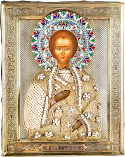
Sold2015ST. PANTELEIMON THE HEALER WITH SILVER-GILT AND ENAMELST. PANTELEIMON THE HEALER WITH SILVER-GILT AND ENAMEL OKLAD Russian, late 19th century (icon), Moscow, 1896-1908 (oklad) Tempera on wood panel. The saint depicted half-length holding a box of medicinSee Sold Price
Sold20241701 MAP OF MOSCOVIA RUSSIA ENGLISH copper engraving ANTIQUEMoscovia or Russia. Divided into its general parts &c. by Moll, Herman (Cartographer) London, Printed for Timothy Childe at the White Hart at the West-end of St. Paul's Church-yard; 1701 size 6 1/2 bySee Sold Price
Sold2023Rare 1925 Map of The Town and Harbor of Nantucket by Phillip L. HallRare 1925 Map of The Town and Harbor of Nantucket by Phillip L. Hall, whimsical map showing the town, harbor, ships, aircraft, and prominent landmarks of the island. Overall 23 in. x 15 in.See Sold Price
Crawford Family Auctions LLCFramed print of Map of Part of the Island of Hawaii & Sandwich Islands, w/COA$20(1 bid)
Jun 15Crescent City Auction GalleryPair of New Orleans Sanborn Fire Insurance Mock-Up Skeleton Maps of the French Quarter, 1910-1911,$250
20 hrs LeftFreeman's | Hindman[MAP]. ORTELIUS, Abraham. Peregrinationis Divi Pauli Typus Corographicus. 1592.$150(1 bid)
Jun 14DuMouchellesRigobert Bonne (French, 1727-1794) Hand Colored Engraving Ca. 18th Century, Les Etats Unis De$50(1 bid)
Jun 14DuMouchellesSterling Silver Proof Coins, Exonumia & Coin Sets, Feat. Franklin Mint, 1969-2020, 28 pcs$225(3 bids)
21 hrs LeftHolabird Western Americana CollectionsSanitary & Topographical "Viele Map" of Manhattan 1865 [182838]$750
2 days LeftTrillium Antique Prints & Rare BooksSanson - Map of California as an Island, Mexico (Audience de Guadalajara)$160(4 bids)
6 days LeftSouth Bay AuctionsCanada Goose Decoy Attributed to George Roberts (Bellport, Long Island)$100
2 days LeftTrillium Antique Prints & Rare BooksSanson - Map of North America with California as an Island$130(4 bids)
Jul 14One of a Kind Coins1 of 1: GEM BU $20 Mixed St. Gaudens & Liberty Head Gold Wax Sealed Bank Bag of 25 Gold Coins$1,100(9 bids)


![Baldwin / Kitchin: Antique Maps Windward Islands, 1782: Title/Content of Map: 1782 Baldwin / Kitchin Maps of the Windward Islands -- Island of St. Lucia [on sheet with] Island of St. Vincent [on sheet with] Island of Barbados [on sheet with] Chart of Part](https://p1.liveauctioneers.com/5584/110608/56777137_1_x.jpg?height=310&quality=70&version=1507840413)


![[MAP]. ORTELIUS, Abraham. Peregrinationis Divi Pauli Typus Corographicus. 1592. (1 of 2)](https://p1.liveauctioneers.com/197/329395/177650535_1_x.jpg?height=282&quality=70&version=1715364962)


![Sanitary & Topographical "Viele Map" of Manhattan 1865 [182838] (1 of 3)](https://p1.liveauctioneers.com/2699/331495/178785766_1_x.jpg?height=282&quality=70&version=1717094933)


![[Maps & Atlases] Oliva, Joan: Portolan Chart of the Mediterranean (1 of 1)](https://p1.liveauctioneers.com/65/332523/179335172_1_x.jpg?height=282&quality=70&version=1717622830)


