Sold2024SOUTH CENTRAL AFRICA. Shows Zambesi river as circular! WELLER 1863 old mapTITLE/CONTENT OF MAP: 'South Central Africa' The map shows early colonial Africa, with the variable hand coloured outline of the continent indicating early claims. The Zambesi river has not been fullySee Sold Price
Sold2022[WESTERN AMERICANA]. The Rosborough family archive, including letters relating to the California[WESTERN AMERICANA]. The Rosborough family archive, including letters relating to the California Gold Rush, the Modoc War, the Klondike Gold Rush, and early settlement and mining operations in Idaho TSee Sold Price
Sold2024Willem Blaeu, Map of The AmericasAmsterdam, 1617. Together with "Early Maps" by Tony Campbell, Abbeville Press and "The United States in Old Maps and Prints, Eduard Van Ermen. 3 pieces Sight size: 16-1/2"h x 22"w Overall: 23-1/2"h xSee Sold Price
Sold2016Huge Sacred African Lobi Tribal Human Shrine VesselWest Africa, Lobi, ca. late 19th to early 20th centuries CE. This is an UNBROKEN shrine vessel from the Lobi Culture of western Africa. Most of these vessels are globular and simple spiked spheres witSee Sold Price
Sold2022Rare 1836 Col. Dodge Expedition map - 1st printing, SteenLarge and important early copper engraved map of the western U. S. showing the route of Col. Henry Dodge’s 1835 Expedition from Fort Leavenworth to the Rocky Mountains. Rare first printing withSee Sold Price
Sold2021CANVASBACK DRAKE, W. HEVERINEARLY CANVASBACK DRAKE by Will Heverin, Chestertown, MD, (1860-1951). Very old working paint and good structural condition. Retains weight and rigging. BILL HEVERIN written on bottom. 200-300See Sold Price
Sold2022Lang Shining hand scrollLang Shining himself is good at painting portraits, Chinese and Western painting methods for portraits are completely different, Lang Shining's early paintings are obvious Western painting styles, sucSee Sold Price
Sold2023Western or Central Anatolian Village Rug Anatolia 4 ft. 10 in. x 7 ft. 7 in.Western or Central Anatolian Village Rug Anatolia c. 17th or early 18th century, worn and with many old restorations, but briming with early Anatolian design elements. 4 ft. 10 in. x 7 ft. 7 in. /auctSee Sold Price
Sold2023De Eylanden van Pehou' by VAN KEULEN. Penghu Islands Taiwan. VOC chart 1753 mapTitle: De Eylanden van Pehou' by VAN KEULEN. Penghu Islands Taiwan. VOC chart 1753 map Description: De Eylanden van Pehou' by Johannes van Keulen (1753). Early 18th century Dutch sea chart with old coSee Sold Price
Sold2016Large Victorian Sterling Silver Circular Footed SalverLarge Victorian Sterling Silver Circular Footed Salver by Edward & John Barnard, London Date Mark of 1860, 19.5'' Diameter & 2.25'' tall. It weighs 81.1 troy ounces (2,524 grams). Old "HHL" monogram oSee Sold Price
Sold2023(CASE MAPS.) Group of 9 nineteenth-and-early-twentieth-century engraved or lithographed case maps of(CASE MAPS.) Group of 9 nineteenth-and-early-twentieth-century engraved or lithographed case maps of various locations. Individual photographs on request. Vp, vd - Edward Stanford. A Map of China. 43&See Sold Price
Sold2021MAP, Western Hemisphere, BlaeuBlaeu's Stunning Carte-a-Figures Map of the Americas in Full Contemporary Color. Western Hemisphere - America. Willem Blaeu, Americae Nova Tabula, 1642 (circa). Hand Color. This stunning carte-a-figurSee Sold Price
Sold20211721 Map of America With California as an IslandHistoric Maps 1721 Hand-Colored "A New Map of America from the Latest Observations" with "California" Shown as an Island 1721 Hand-Colored Engraved Western Hemisphere Map titled, "A New Map of AmericaSee Sold Price
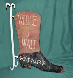
Sold2022Antique Boot Trade SignAbsolutely spectacular early double sided store front trade sign for old boot shop, with great original color, and stylish wall flange. Dimensions 31" tall and 24" wide.See Sold Price
Sold2023EDWARD CURTIS (1868-1952) GOLDTONE NATIVE AMERICAN PHOTOFANTASTIC EARLY 20TH CENTURY ORIGINAL GOLD OROTONE PHOTO ON GLASS BY EDWARD CURTIS (1868-1952) - TITLE IS "THE OLD WELL AT ACOMA" IN ORIGINAL FRAME - SIGNED "CURTIS" IN LOWER LEFT - VERY GOOD CONDITIOSee Sold Price
Sold2021Four Antique MapsFour antique maps. Including a very early hand made paper map of Florida and Virginia. Fragment of old newspaper on back dated 1630. Unframed, each approx H 21" W 24". All in excellent condition, minoSee Sold Price
Sold2017Chinese Archaic Bronze Food Vessel Li Ding Shang/XizhouChinese Archaic Bronze Food Vessel, Li Ding, Late Shang/ Early Western Zhou Dynasty. Diameter 6 1/2 inches, Height 4 7/8 inches. Provenance: Ji Zhe Zhai's collection. Sold at Sotheby's auction NovembeSee Sold Price
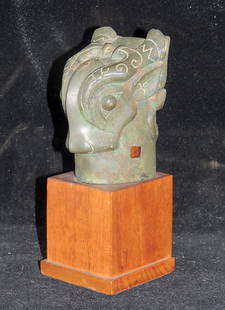
Sold2016Rare and Important Chinese Double Sided Archaic BronzeRare and Important Chinese double sided archaic bronze double-sided pole finial. Shang/Early Western Zhou Dynasty period. Ca. 11th/10th century BC. Featuring a cast taotie head surmounted with horns.See Sold Price
Sold202278208: A Chinese Archaic Bronze Liding Food Vessel, LatA Chinese Archaic Bronze Liding Food Vessel, Late Shang/Early Western Zhou Dynasty 5 x 6-1/2 x 6-1/2 inches (12.7 x 16.5 x 16.5 cm) PROVENANCE: SSee Sold Price
Sold2022David Kammerzell - Golden TomDavid Kammerzell - Golden Tom Oil, acrylic, and gold paint wood panel Signed "Golden Tom is a portrait of early western film star Tom Mix. Mix was an fascinating blend of a real, working cowboy and aSee Sold Price
Sold2021Miro litho Joueur de Bugle, 46 x 31, Soth provenanceMiro lithograph: Joueur de Bugle Aux Oiseaux,46 x 31(sight to the mat), Sothebys provenance, and Estate of Edward Lubin, Old Master specialist Davids notes: A terrific and huge Miro lithograph with ouSee Sold Price
Sold2020Gastaldi Map of Africa*** START PRICE IS THE RESERVE *** [Africa]. GASTALDI, Giacomo (1500-1566) & FORLANI, Paolo (fl. 1560-1571). La Descrittione dell'Africa. Engraved Map. Venice: Paolo Forlani, 1562. 19 x 25 1/4 inchesSee Sold Price
Sold2021Edward Hill 1879 - Old Man of Mountain SignedLandscape of Riders on Horses overlooking River and Old Man and the Mountain Signed "Edward Hill 1879" in gold Gild Frame - Canvas raised outward where it meets frame in lower left. Has some paint losSee Sold Price
Sold2020Mitchell Map of Western U.S.*** START PRICE IS THE RESERVE *** [America] MITCHELL, Samuel Augustus (1792-1868). A New Map of Texas, Oregon and California with the Regions Adjoining. Engraving with original hand color, with origiSee Sold Price
1 day LeftJasper52Turkestan, or Independent Tartary by Edward Weller. Central Asia 1860 old map$40(1 bid)
Jun 02Schilb Antiquarian Rare Books1880 BIBLE Gallery Gustave Dore ART Illustrated Old/New Testament Bible Scenes$42(3 bids)
4 days LeftTrillium Antique Prints & Rare BooksPrevost - Chart of the Gulf of Mexico (with Florida & Lousiana)$50(1 bid)
2 days LeftPotter & Potter Auctions[NAVAL CHRONOMETER]. Eight-Day Boxed Ship’s Chronometer. Lo...$6,000
Jun 07Freeman's | HindmanHOMANN, Johann Baptist. Amplissimae Regionis Mississipi Seu Provinciae Ludovicianae. Nuremburg, [ca$400(1 bid)


![[WESTERN AMERICANA]. The Rosborough family archive, including letters relating to the California: [WESTERN AMERICANA]. The Rosborough family archive, including letters relating to the California Gold Rush, the Modoc War, the Klondike Gold Rush, and early settlement and mining operations in Idaho T](https://p1.liveauctioneers.com/197/250551/130130199_1_x.jpg?height=310&quality=70&version=1654185975)


![Gastaldi Map of Africa: *** START PRICE IS THE RESERVE *** [Africa]. GASTALDI, Giacomo (1500-1566) & FORLANI, Paolo (fl. 1560-1571). La Descrittione dell'Africa. Engraved Map. Venice: Paolo Forlani, 1562. 19 x 25 1/4 inches](https://p1.liveauctioneers.com/1968/163248/82424552_1_x.jpg?height=310&quality=70&version=1583340284)

![Mitchell Map of Western U.S.: *** START PRICE IS THE RESERVE *** [America] MITCHELL, Samuel Augustus (1792-1868). A New Map of Texas, Oregon and California with the Regions Adjoining. Engraving with original hand color, with origi](https://p1.liveauctioneers.com/1968/163248/82424595_1_x.jpg?height=310&quality=70&version=1583340284)


![[NAVAL CHRONOMETER]. Eight-Day Boxed Ship’s Chronometer. Lo... (1 of 4)](https://p1.liveauctioneers.com/928/328184/176813350_1_x.jpg?height=282&quality=70&version=1714496988)


