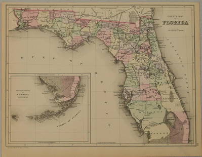
Sold20211883 Mitchell/Bradley Map of Florida -- County Map ofTitle: 1883 Mitchell/Bradley Map of Florida -- County Map of Florida Cartographer: Mitchell / Bradley Year / Place: 1883, Philadelphia Map Dimension (in.): 10.5 X 14.4 in. This is a rather handsome coSee Sold Price
Sold2019(16) 19TH C. BRADLEY & BROS. MAPS C. 1889(16) maps. Maps of the United States including one railway map. Dimensions: H 19.25" x W 26.5" Condition: Normal age related toning. Each with creases at center.See Sold Price
Sold2016County Map of the State of Texas 1884Map Title: County Map of the State of Texas Date: 1884 Publisher: WM. M. Bradley & Bro: Philadelphia Size: 14.25 x 21.25 inches Showing also portions of the adjoining states and territories." IncludesSee Sold Price
Sold2018County Map of the States of Delaware, Maryland,Reserve Reduced! Title: County Map of the States of Delaware, Maryland, Virginia And West Virginia Publication Date: 1886 Cartographer: MITCHELL, S. AUGUSTUS, JR. Publisher: BRADLEY & BRO. Size: 14.5See Sold Price
Sold2023County & Township Map of the States of Kansas and NebraskaPublication Date: 1887 Title: County & Township Map of the States of Kansas and Nebraska Cartographer: WM. BRADLEY & BRO. Publisher: WM. BRADLEY & BRO. Height: 14.3 Width: 20 Map showing towns, townshSee Sold Price
Sold2019Samuel Augustus Mitchell (1790-1868), "County Map ofSamuel Augustus Mitchell (1790-1868), "County Map of Florida," 1867, Atlas, with an inset of Mobile, H.- 12 in., W.- 12 3/8 in.See Sold Price
Sold2019Samuel Augustus Mitchell (1790-1868), "County Map ofSamuel Augustus Mitchell (1790-1868), "County Map of Florida, North Carolina, South Carolina," 1860, H. - 12 1/4 in., W. - 15 3/8 in.See Sold Price
Sold2020County and Township Map of the States of Michigan andTitle/Content of Map: County and Township Map of the States of Michigan and Wisconsin Cartographer: BRADLEY, WILLIAM M. Date: 1887 Publisher: WM. M. BRADLEY & BRO. Size: 15Height - 20.5Width Detailed,See Sold Price
Sold2020County and Township Map of Montana, Idaho and WyomingTitle: County and Township Map of Montana, Idaho and Wyoming Publication Date: c1886 Cartographer: MITCHELL, SAMUEL AUGUSTUS (JR.)/WM. M. BRADLEY & BRO. Publisher: WM. BRADLEY & BRO. Brief DescriptionSee Sold Price
Sold2023MAPS: MITCHELL NEW ORLEANS, FLORIDA, ARKANSASUnframed map, Samuel Augustus Mitchell, Jr., copyright 1882, depicting "Plan of New Orleans, "Country Map of Florida" on one side, "County Map of the States of Arkansas, Mississippi and Louisiana" onSee Sold Price
Sold2019Three Maps by Samuel Augustus Mitchell (1790-1868), "Three Maps by Samuel Augustus Mitchell (1790-1868), " County Maps of Arkansas, Louisiana and Mississippi, Verso with Florida, and a Plan of New Orleans" 1882, hand colored, on two pages, H.-24 in., W.See Sold Price
Sold20202 Hand Colored Maps - Florida & AlabamaTwo Gray's Atlas Maps on one sheet - Florida & Alabama Depicts railroad lines, common roads, canals, topography, etc. Maps are on each side of one sheet. A beautiful & rarSee Sold Price
Sold2017John Tallis et al., regional United States mapsJohn Tallis et al., regional United States maps, John Tallis & Co. (American, 19th. c), "United States", c. 1851, 11"h x 14"w (sheet); Samuel Mitchell (American, 19th c.), "County Map of Pennsylvania,See Sold Price
Sold2022Henri Burkhard, oil on boardHenri Burkhard, oil on board, Henri Burkhard (American, 1882-1956), "Montgomery County, PA", signed lower right, titled verso, 16"h x 24"w (sight), 17.5"h x 25"w (frame) Provenance: The Collection ofSee Sold Price
Sold20231887 Bradley map of Quebec -- Map of Quebec in CountiesTitle: 1887 Bradley map of Quebec -- Map of Quebec in Counties Cartographer: W Bradley Year / Place: 1886, Philadelphia Map Dimension (in.): 10.5 X 13.4 in. This is an excellent map of Quebec along thSee Sold Price
Sold2021County map of FloridaTitle: County map of Florida Artist: S. Augustus Mitchell, Jr. Medium: Lithograph Dimensions: 10 1/2 x 13 1/4 Description: 1881 map of Florida, with inset of Mobile Reserve: $75.00 Shipping: DomeSee Sold Price
Sold20181887 Mitchell Map of Florida -- County Map of FloridaTitle/Content of Map: 1887 Mitchell Map of Florida -- County Map of Florida Date: 1887, Philadelphia Cartographer: S Mitchell Size: 10.7 X 14.3 in. Handsome county map of Florida. In this derivative mSee Sold Price
Sold20231860 Mitchell Map of Florida, South and North Carolina -- County Map of Florida on page with Map ofTitle: 1860 Mitchell Map of Florida, South and North Carolina -- County Map of Florida on page with Map of South Carolina, on page with County Map of North Carolina Cartographer: S Mitchell Year / PlaSee Sold Price
Sold2018Railroad and County Map of Florida.Title/Content of Map: Railroad and County Map of Florida. Date: 1887 Cartographer: CRAM, GEORGE F. Size: 21.8X15.6 From the Grant's Standard American atlas, cover date 1887. Shows railroads finished aSee Sold Price
Sold2018Mitchell: Antique County Map of Florida, 1870County Map of Florida The beautifully detailed and colored county map of Florida from the 1870 edition of Mitchell's popular New General Atlas of the world. Framed by the vine motif border typical ofSee Sold Price
Sold20221876 Mitchell Map of Florida -- County Map of FloridaTitle: 1876 Mitchell Map of Florida -- County Map of Florida Cartographer: S Mitchell Year / Place: 1876 Philadelphia Map Dimension (in.): 10.6 x 13.5 in. Handsome county map of Florida. Virtually allSee Sold Price
Sold2019County Map of Florida.Title: County Map of Florida. Publication Date: 1861 Cartographer: MITCHELL, SAMUEL AUGUSTUS (JR.) Publisher: S. Augustus Mitchell, Jr. Size: 10.6Height - 13.25Width Map 25 from Mitchell's New GeneralSee Sold Price
Sold2016Mitchell: County Map of Florida 1867Map: County Map of Florida Maker: Mitchell Size: 11 x 13.25 inches Counties in original wash color. Inset of Mobile, AL. No Reserve: This lot starts at $1 and has no reserve as a courtesy so that collSee Sold Price
Sold2023Rare 1st state of Florida map from 1st printing of 1860 atlasFirst edition, first state of S. A. Mitchell Jr.'s County Map of Florida/County Map of South Carolina. Maps from Mitchell Jr’s first printing of his first New General Atlas are distinguished bySee Sold Price
6 days LeftJasper521896 Cram Map of Virginia, West Virginia, Maryland and Delaware -- Railroad and County Map of$40
May 14Akiba Galleries(2 Pc) Allain Manesson Mallet Description De L'Univers 2 Vol. German Translation$200(1 bid)
3 days LeftTremont Auctions18th century map of New Jersey. "A New and Accurate Map of New Jersey". W. Long, London. Map size 13$100
May 18Rich Penn AuctionsDrug Store Thermometer, Lash's Bitters for Constipation and Homer's Ginger and Brandy for Diarrhoea$70(2 bids)
2 days LeftMynt AuctionsDeion Sanders Autographed Florida State White Speed Mini Helmet-Beckett W Holo$10
May 18Rich Penn AuctionsCountry Store Lace Rack, "Happy Thoughts Lace", mfgd by Wiedemeier Bros-Carroll, IA, nickel-plated$60(2 bids)


![[Maps] Gio. Ant. Magnini, Italia, 1620 (1 of 11)](https://p1.liveauctioneers.com/188/326797/176317457_1_x.jpg?height=282&quality=70&version=1713847031)
![[Maps] Martin Zeiler, Itinerarium Italiae, 1640 (1 of 9)](https://p1.liveauctioneers.com/188/326797/176317459_1_x.jpg?height=282&quality=70&version=1713847031)


