Sold2017von Reilly: Map of North America, 1795Map: Karte von Amerika Nach d'Anville und Pownall/Karte von der Republik der Vereinigten Dreyzehen Staaten in Nord Amerika Cartographer: von Reilly Place & Date: Vienna / 1795 Size: 30" x 23" A highlySee Sold Price
Sold2018Mitchell: Antique Map of New York State w/ city insetsCounty Map of the State of New York The beautifully detailed and colored county map of New York State from the 1870 edition of Mitchell's popular New General Atlas of the world. Framed by the vine motSee Sold Price
Sold2022Antique Map: Erzherzogthum Oesterreich... Von Reilly, Wien, 1796, Unframed.Antique Map: Erzherzogthum Oesterreich... Von Reilly, Wien, 1796, Unframed.See Sold Price
Sold20231795 HISTORY of POLAND In ENGLISH antique w/ MAPHISTORY of POLAND Dublin; 1795 Size 3 1/4 by 5" Illustrated with folding map. Later cloth binding with gilt title at the spine Good interior condition, some spots at the margins, some wear of the bindSee Sold Price
Sold20241797 WORLD'S HISTORY antique ILLUSTRATED w/ MAP of ARABIA in German VELLUM BOUNDUebersetzung der Algemeinen Welthistorie die in Engeland durch eine Geselschaft von Gelehrten ausgefertiget worden (General World's History) By Siegmund J. Baumgarten Written in England by a society oSee Sold Price
2017Homann: Antique Map of Malta & Valetta View, 1720Map: Insularum Maltae et Gozae Cartographer: J. B. Homann Place & Date: Nurnberg / 1720 Size: 20" x 18" Condition: old color on islands and inset plan, cartouche and inset view in b&w; light overall aSee Sold Price
Sold2018Meyer: Antique Map of Ohio with Cincinnati Inset, 1849Map: Neueste Karte von Ohio 1849 Cartographer: Bibliographischen Instituts. Place & Date: Hildburghausen / 1849/1857 Size: 11 7/8" x 14 5/8" Condition: original outline color; light overall age toningSee Sold Price
Sold2017Bellin: Antique Map of Louisiana/Mississippi Basin 1750Map: Karte von Luisiana, dem Laufe des Mississippi und den Benachbarten Laendern Cartographer: Bellin Place & Date: Leipzig / 1750 (?) Size: 21 1/2" x 15 1/2" Condition: b&w; overall age toning, a fewSee Sold Price
Sold2017Antique Map of Washington, D.C., 1857Map: Plan von Washington 1857 Cartographer: Bibliographischen Instituts. Place & Date: Hildburghausen / 1849/1857 Size: 14 1/2" x 11 3/4" Condition: b&w; light overall age toning, minor spotting alongSee Sold Price
Sold2017Guillaume: Antique Map of Cuba, 1825Map: Ile De Cuba. Publication Date: 1825 Authors: PH. VANDERMAELEN, VANDERMAELEN, PHILIPPE MARIE GUILLAUME (1795-1869) Publisher: PH. VANDERMAELEN Size: Folio – 18.00 H x 21.00 W Inches Amer. Sep. NSee Sold Price
Sold2017Bellin: Antique Map of St Lawrence Region, 1744Map: Karte Von Dem Flusse Richelieu Und Dem See Champlain Publication Date: 1744 Authors: BELLIN, NICOLAS Size: Octavo – 12.00 H x 5.30 W Inches Nach den Manuscripten des Schatzes von Karten GrundriSee Sold Price
Sold2017Petermann: Antique Map of Europe, 1881Map: Europa Publication Date: 1881 Authors: JUSTUS PERTHES, PETERMANN, A. | HABENICHT, H. Publisher: JUSTUS PERTHES Size: Folio – 13.00 H x 16.00 W Inches Im Maasstab von 1:15.000.000. From: AdSee Sold Price
Sold2018Antique Map of Capt. Cook’s Route / Friendly IslandsTitle/Content of Map: Carte von den Freundschaftlichen Inseln Place & Date: Germany / 1786 Size: 14 3/4" x 9 3/8" Condition: b&w; very light overall age toning, otherwise in excellent condition A simpSee Sold Price
Sold2018Bellin: Antique Map of Ancient Mexico City Region, 1760Map: Karte von dem See von Mexico Cartographer: Bellin / Arkstee&Merkus Place & Date: Leipzig / 1760 Size: 5 7/8" x 7 7/8" Condition: b&w; overall age toning and light browning Bellin's detailed map oSee Sold Price
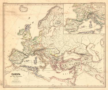
Sold2018Menke: Antique Map of Europe at time of OdovacarsTitle/Content of Map: Europa Zur Zeit Odovacars (476-493.) Date Printed: 1874 Cartographer: MENKE, TH. Publisher: JUSTUS PERTHES 1874 GOTHA Size: Quarto – 12.80 H x 15.75 W Inches "Von Th. Menke..."See Sold Price
Sold2019Franz Joseph Von Reilly (1766-1820), "Karte von AmericaFranz Joseph Von Reilly (1766-1820), "Karte von America nach D'Anville and Pownall, 1756 (Inset) Karte von der Republik Der Vereinigten Dreyzehn Staten In Nord America, 1777," H. - 24 in., W. - 31 in.See Sold Price
Sold2018W. Williams - Colored Map of AfricaAntique map of the continent with inset map of Island of St. Helena. 11" X 13.5" (19" X 21.5")See Sold Price
Sold2023SOUTH AMERICA PHYSICAL. Inset West-East cross section. JOHNSTON 1897 old mapTitle: SOUTH AMERICA PHYSICAL. Inset West-East cross section. JOHNSTON 1897 old map Description: South America (Physical)' by W. & A.K. Johnston (1897). Antique colour map, 26.5 x 20.0cm, 10.5 x 7.75See Sold Price
Sold2023SOUTH AMERICA PHYSICAL. Inset West-East cross section. JOHNSTON 1906 old mapTitle: SOUTH AMERICA PHYSICAL. Inset West-East cross section. JOHNSTON 1906 old map Description: South America (Physical)' by W. & A.K. Johnston, Limited Edinburgh & London (1906). Antique colour map,See Sold Price
Sold2019Two Maps; Unknown, "Charte von den NordwestkusteTwo Maps; Unknown, "Charte von den Nordwestkuste Americas Nach Vancouver," Prague, 1818, H. - 10 in., W. - 8 in.; together with Unknown, "Charte der neuen Niederlassungen in Ober Canada each der mythsSee Sold Price
Sold2023Allan Gould coffee table for Reilly-Wolf Associates. Inset marble top.Allan Gould coffee table for Reilly-Wolf Associates. Inset marble top. Dimensions: H: 14 inches: W: 33 inches: D: 33 inches --- We offer curbside delivery to NYC, Manhattan, Close Brooklyn, Hoboken abSee Sold Price
Sold2023SOUTH AMERICA PHYSICAL. Inset West-East cross section. JOHNSTON 1900 old mapTitle: SOUTH AMERICA PHYSICAL. Inset West-East cross section. JOHNSTON 1900 old map Description: South America (Physical)' by W. & A.K. Johnston, Limited, Edinburgh & London (1900). Antique colour mapSee Sold Price
Sold2023SOUTH AMERICA PHYSICAL. Inset West-East cross section. JOHNSTON 1895 old mapTitle: SOUTH AMERICA PHYSICAL. Inset West-East cross section. JOHNSTON 1895 old map Description: South America (Physical)' by W. & A.K. Johnston, Limited, Edinburgh & London (1895). Antique colour mapSee Sold Price
Sold20241598 COSMOGRAPHY by Sebastian Munster antique RARE ILLUSTRATED w/ MAPS PIGSKINMUNSTER, Sebastian (1489-1552). Cosmographey, das ist, Beschreibung aller Länder, Herrschafften und fürnemesten Stetten des gantzen Erdbodens Cosmography: that is, description of all countries... BaSee Sold Price
5 days LeftJasper52Monument of General Hoche at Neuwied by W. Tombleson after J.Watts. 1835 engraving$15
Featured5 days LeftJasper521831 Woodbridge Map of South America and Africa -- Comparative, Geographical & Statistical Map of$70